
24.5
PDI
10.8 mi
DISTANCE
3,938 ft
GAINED
6.8 %
AVG. GRADE
FULL CLIMB STATS
INTRO
PLAN YOUR ROUTE
 We've partnered with Sherpa-Map.com to bring you the best route planning tool. With a PRO Membership you can use this climb as a reference when creating your route.
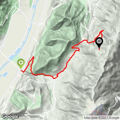
 Station du Barioz averages 6.8% over 17.4 km (10.8 mi) from Tencin, gaining 1,200 m (3,938 ft) from 253 m (831 ft) up to 1,439 m (4,721 ft) at the ski station.
The climb is steady rather than relentless, but it isn't a smooth grind either. The steepest 100 meters average 16.3%, the steepest quarter-mile averages 13.0%, and the steepest half-mile settles to 10.1% - short, sharper ramps early on give way to a longer, more even grade through the upper forest. The steepest 5 km stretch of the route still averages 7.6%, which is a fair summary of the climb's character: consistent work with no single defining wall.
There's a small amount of rolling terrain along the way, with about 15 m (48 ft) of net descent mixed into the ascent, mostly through the village of Theys.
Roadway: The road (Route du Col du Barioz, becoming Route des Alpages higher up) is paved for its entire length and generally in decent condition. Riders have reported occasional loose gravel in the corners on the upper switchbacks, carried down from the surrounding forest - worth a bit of caution, especially on the descent.
Traffic: Traffic is heaviest at the bottom, on the approach through Tencin and Theys. Above Theys the road narrows and quiets down considerably, with only local and recreational traffic headed to the ski station.
Parking: Roadside parking is available in Tencin at the base of the climb, and again at the ski station itself, where a small day-use lodge serves the alpine and Nordic ski lifts and has a parking area that makes a natural turnaround point.
The grade stays moderate for most of the climb, but the steep early ramps out of Tencin and the occasional pitch higher up reward a compact crankset (34/50) and a wide-range cassette (30-32t low gear) over a standard double.
There are no services once you leave Tencin, so fill bottles and carry food before starting - the ski station's day-use lodge is only reliably open in winter. Forest cover keeps much of the climb shaded, which helps on hot days but also means the road can stay damp longer after rain.
Before heading out on any cycling adventure check out our Things to Bring on a Cycling Trip and use our interactive check list to ensure you don't forget anything.
Tencin sits in the Isère valley about 30 minutes northeast of Grenoble, making Station du Barioz a convenient half-day climb for riders based in the city rather than a standalone destination. The Belledonne massif it climbs into is better known locally for hiking and Nordic skiing than for road cycling, which keeps traffic light even on summer weekends.
Because the road is fully forested for most of its length, this is a good option on a hot day when more exposed Alpine climbs nearby would be brutal in the afternoon sun - just note the flip side is fewer sweeping views until the final kilometers near the ski station, where the Chartreuse massif opens up across the valley.
The climb is rideable from late spring through fall; the ski station itself closes for the season once the snow arrives, typically by late autumn.
ROUTE MAP
MEMBER RATING
CURRENT WEATHER
PJAMM TRIPS ADVENTURE STARTER BUNDLES
Check out PJAMM Adventure's prepackaged (self-guided) cycling trips. They will help you plan, document and conquer your next adventure.
NEARBY CLIMBS (0) RADIAL PROXIMITY
FROM No Climbs Found
MEMBER REVIEWS & COMMENTS
Let us know what you thought of this climb. Signup for our FREE membership to write a review or post a comment.
Already have an account?
LOG IN HERE
