17.3
PDI
12.4 mi
DISTANCE
3,217 ft
GAINED
4.9 %
AVG. GRADE
FULL CLIMB STATS
Page Contributor(s): Chris Monson, Blanding, Utah, USA
INTRO
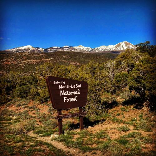
This 12.4 mile bike climb is located in UT, USA. The average gradient is 4.9% and there is a total elevation gain of 3,217 ft, finishing at 7,954 ft.
Use the profile tool, route map, and weather forecast to conquer this cycling climb.
Use the profile tool, route map, and weather forecast to conquer this cycling climb.
PLAN YOUR ROUTE
See more details and tools regarding this climb's grade via our interactive Profile Tool.
Information Not Available
If you have any information regarding this climb, we'd like to hear from you. Click the CONTRIBUTE button to share your thoughts with us.
Information Not Available
If you have any information regarding this climb, we'd like to hear from you. Click the CONTRIBUTE button to share your thoughts with us.
Before heading out on any cycling adventure check out our Things to Bring on a Cycling Trip and use our interactive check list to ensure you don't forget anything.
Information Not Available
If you have any information regarding this climb, we'd like to hear from you. Click the CONTRIBUTE button to share your thoughts with us.
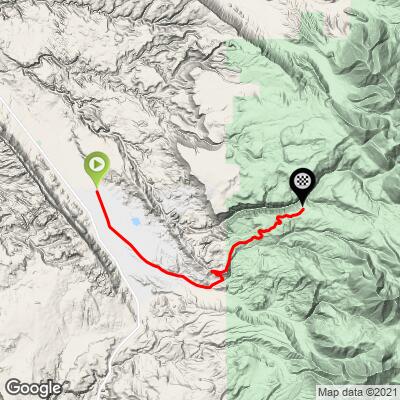
ROUTE MAP
MEMBER RATING
CURRENT WEATHER
PJAMM TRIPS ADVENTURE STARTER BUNDLES
Check out PJAMM Adventure's prepackaged (self-guided) cycling trips. They will help you plan, document and conquer your next adventure.
NEARBY CLIMBS (0) RADIAL PROXIMITY
FROM No Climbs Found
MEMBER REVIEWS & COMMENTS
Let us know what you thought of this climb. Signup for our FREE membership to write a review or post a comment.
Already have an account?
LOG IN HERE
Skotscott
July 28, 2023
107° in the valley at the start and 92° at the summit. No water available on the route. This is a much harder climb than the other side (Castle Valley) and the road is in need of repaving. Not so bad on the way up but not fun on the way down - holes, cracks, bad repairs, rough areas. A wonderful long section at 11 to 15% will test your lungs and legs ! Numerous false summits. Big parking area at the top with grand views of Castle Valley. For a harder workout, continue over and down to Castle Valley to the Colorado River and hwy 128 on a very good road with safe, fast decent and light traffic. The climb back up is more moderate than the Spanish Valley side.
trier1992

Great ride mid-May, 2021. This ride really has a few painfully steep sections, but they're all relatively short. Totally worth it for anyone looking to climb their bike around Moab. The ending doesn't really have a summit, so any good pics have to come from some of the roadside pull-offs.
KrisLJames262
Great climb in the Moab area. In late Feb there was little if any traffic. Be prepared for the “big nasty†section.