

25.5
PDI
11.8 mi
DISTANCE
4,085 ft
GAINED
6.5 %
AVG. GRADE
FULL CLIMB STATS
INTRO
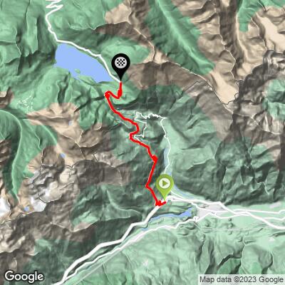
Col du Mont Cenis from Susa is one of the great historic crossings of the Alps - 18.9 km (11.8 mi) climbing 1,245 m (4,085 ft) at a 6.5% average grade from the Italian town of Susa up to the French border and the shores of Lac du Mont Cenis, at 2,060 m (6,760 ft).
People have crossed this pass for thousands of years - Hannibal is sometimes credited with using it, and both Constantine and Charlemagne led armies over it in antiquity and the early Middle Ages. The modern road dates to Napoleon, who ordered it built in 1803 so wheeled carriages and artillery could cross where mule trains once had to disassemble their wagons; it took ten years and 3,000 laborers to complete.
The Tour de France has used Mont Cenis five times (1949, 1956, 1961, 1992, 1999), twice from this harder Italian side. The French side descends past Lac du Mont Cenis, an artificial reservoir created in 1968 that submerged the historic hospice at the summit - only its bell tower still breaks the surface.
PLAN YOUR ROUTE
 We've partnered with Sherpa-Map.com to bring you the best route planning tool. With a PRO Membership you can use this climb as a reference when creating your route.
 18.9 km (11.8 mi) at a 6.5% average is a long, fairly steady effort rather than a series of sharp ramps - typical of an old carriage road built to a consistent, manageable grade for horse-drawn traffic. The steepest kilometer averages 8.8%, and the steepest 500-meter stretch reaches 9.4% - both modest by high-Alps standards.
The real difficulty here is the sustained 18.9 km of climbing at altitude, not any single pitch - pacing matters more than gearing.
Roadway: The road is paved the entire way from Susa to the pass and is well maintained in season - this is a major, historic international route, not a backwater. Like every high Alpine pass in the area, it closes for winter: the French side typically shuts from the second Monday in November to the second Friday in May, reopening for the 2026 season on May 22. Check savoie-route.fr for current status before planning a visit outside peak summer months.
Traffic: Moderate. This is a working border crossing and a popular tourist drive in summer, so expect a steady stream of cars and motorcycles, especially on weekends - busier than a typical quiet Alpine backroad, though nothing like a coastal highway.
Parking: Susa itself has several options at the base - see the nearby Colle delle Finestre climb page (which starts from the same town) for details on the train-station lot and central Piazza della Repubblica, both about as convenient for this climb's start. At the top, there's ample pull-off parking along the shore of Lac du Mont Cenis near the visitor center and Fort Variselle.
Standard climbing gearing is enough here - a compact crank covers the 6.5% average comfortably, since nothing on the road approaches double digits.
The bigger consideration is altitude and weather: the summit sits over 2,000 m, so pack a layer for the descent and a wind vest even in summer, and carry enough water and food for close to two hours of steady climbing, since services thin out well before the pass.
Before heading out on any cycling adventure check out our Things to Bring on a Cycling Trip and use our interactive check list to ensure you don't forget anything.
The Lac du Mont Cenis plateau is worth lingering on beyond just the climb - the lake itself is an artificial reservoir built in 1968 that drowned the historic hospice at the summit, and a small chapel and visitor center now sit near the dam with exhibits on the pass's long history. Fort Variselle, part of a 19th-century Alpine defense network, is visible near the eastern shore.
Susa, at the base, is a good-sized town with plenty of lodging and dining if you're staying over - see the Colle delle Finestre climb page, which also starts from Susa, for base-town specifics.
Check the Routes in the Area tool for other climbs starting from Susa and around the Mont Cenis area.
ROUTE MAP
MEMBER RATING
CURRENT WEATHER
PJAMM TRIPS ADVENTURE STARTER BUNDLES
Check out PJAMM Adventure's prepackaged (self-guided) cycling trips. They will help you plan, document and conquer your next adventure.
NEARBY CLIMBS (0) RADIAL PROXIMITY
FROM No Climbs Found
MEMBER REVIEWS & COMMENTS
Let us know what you thought of this climb. Signup for our FREE membership to write a review or post a comment.
Already have an account?
LOG IN HERE
Cyclopaat
There's a better route: instead of staying on the main road, turn right onto the SP210 toward Novalesa. This is on a narrower, quieter route with steeper ramps and a descent after Montceniso (town) before rejoining the main ascent higher up.
