
25.2
PDI
9 mi
DISTANCE
3,574 ft
GAINED
7.4 %
AVG. GRADE
FULL CLIMB STATS
INTRO
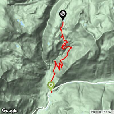
Ruisseau de la Chavière climbs out of Termignon, in the Val-Cenis commune of the Haute-Maurienne, and follows the valley of the Chavière stream deep into the Vanoise National Park. From the village the road covers 14.5 km (9.0 mi) and gains 1,089.4 m (3,574 ft) at a 7.4% average grade, topping out around 2,366.5 m (7,764 ft) near the Plan du Lac refuge.
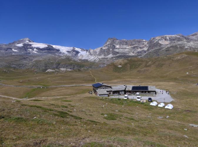
The first half is a relentless, shaded switchback climb through forest with almost no flat ground to recover on. Past the Chavière alpine farm and the Bellecombe trailhead parking, the road breaks out of the trees into open high-alpine pasture, with the glaciated Dent Parrachée and Dôme de Chasseforêt filling the skyline the rest of the way to Plan du Lac.
This is one of the wildest paved roads in the Maurienne - locals who've ridden both regularly rate it tougher than the Col de l'Iseran or Col du Mont Cenis despite its more modest stats, and marmots crossing the road are a genuine hazard, not just scenery. Beyond the Bellecombe parking area the road narrows and is closed to private motor traffic (aside from a seasonal shuttle), so the closing kilometers into the national park are shared only with hikers and fellow cyclists.
PLAN YOUR ROUTE
 We've partnered with Sherpa-Map.com to bring you the best route planning tool. With a PRO Membership you can use this climb as a reference when creating your route.
 The 7.4% average hides a lot of variation. The opening kilometer is the hardest sustained stretch, averaging 10.1%, and the steepest single mile comes in at 9.9% - both concentrated in the forested switchbacks straight out of Termignon. The steepest 100 yards on the whole route spikes to 14.1%.
After the initial push the grade eases slightly and stays fairly consistent through the alpine section above Bellecombe, without ever offering a genuine flat stretch to recover on. Riders who've done both often find this climb harder in practice than its 7.4% average suggests, tougher even than nearby Col de l'Iseran or Col du Mont Cenis by most local accounts.
Roadway: The road is paved the entire way to Plan du Lac, but multiple rider reports describe the surface as only average - some patchy asphalt and loose stones, especially through the forested lower switchbacks, so it's worth extra caution on the way back down. Beyond the Bellecombe parking area the pavement narrows further as it enters the national park.
Traffic: Traffic is light overall but not zero on the lower half - in July and August, day hikers drive up to the Bellecombe trailhead in real numbers, so expect more cars before about 9-10am, especially on weekends. Past Bellecombe, private motor vehicles are banned (aside from a seasonal hiker shuttle), so the final kilometers into the park are shared only with other cyclists and hikers on foot.
Parking: Most riders start from Termignon itself, parking near the village center close to the junction with La Pleureuse memorial where the Plan du Lac road splits off. There's also a large trailhead parking area at Bellecombe, about two-thirds of the way up, if you'd rather split the ride or are combining it with a hike.
Termignon has the last shops, water, and the nearest bike shop (a Ski Set outlet) before the climb - there's nothing beyond the village until the Plan du Lac refuge at the top, which serves food and drinks when staffed (roughly mid-May through October, weather and snow permitting). Fill your bottles before you leave.
A compact or triple crankset is a real asset here - the forested lower kilometers rarely dip below 9-10%, and there's no flat section anywhere to bank recovery time. Standard road tires are fine since the road is paved throughout, but several rider reports mention loose stones on the road surface, particularly on the descent, so keep some reserve braking margin rather than carrying full speed through the switchbacks.
Before heading out on any cycling adventure check out our Things to Bring on a Cycling Trip and use our interactive check list to ensure you don't forget anything.
Termignon is a quiet village in the Val-Cenis commune, on the main road up toward the Col de l'Iseran, and a good base for exploring the Haute-Maurienne's other climbs. Before you start, it's worth a short detour to see La Pleureuse, the village's striking war memorial depicting a woman in traditional Savoyard dress mourning the local dead of the First World War - it sits right at the junction where the Plan du Lac road splits off from the main route toward Lanslebourg and the Iseran.
In July and August, day hikers drive up to the Bellecombe parking area in real numbers, so the lower and middle sections of the road see noticeably more car traffic before about 9-10am than later in the day. Beyond Bellecombe, though, the road is closed to private cars and the ride quiets down completely for the final kilometers into the national park. See our Routes in the Area tool for other Haute-Maurienne climbs worth combining with this one.
ROUTE MAP
MEMBER RATING
CURRENT WEATHER
PJAMM TRIPS ADVENTURE STARTER BUNDLES
Check out PJAMM Adventure's prepackaged (self-guided) cycling trips. They will help you plan, document and conquer your next adventure.
NEARBY CLIMBS (0) RADIAL PROXIMITY
FROM No Climbs Found
MEMBER REVIEWS & COMMENTS
Let us know what you thought of this climb. Signup for our FREE membership to write a review or post a comment.
Already have an account?
LOG IN HERE
