
19.8
PDI
7.5 mi
DISTANCE
2,915 ft
GAINED
7.3 %
AVG. GRADE
FULL CLIMB STATS
INTRO
Montée du Barrage climbs 12.1 km (7.5 mi) from Avrieux, in the Arc valley of the Haute-Maurienne, to the Plan d'Aval and Plan d'Amont dams above Aussois. It gains 888.5 m (2,915 ft), from 1,157.6 m (3,798 ft) to 2,034.8 m (6,676 ft), at a 7.3% average, and ranks #1,015 on our list of the world's hardest climbs.
The first stretch follows the valley road toward Aussois, and then the Route des Barrages turns uphill and the real climb begins. The steepest kilometer averages 10.1% and the steepest 5 km (3.1 mi) average 9.3%, with the road working up through forest in a long series of hairpins. Along the way you pass a viewpoint car park with views toward the Fort d'Aussois, then the lower Plan d'Aval reservoir, before a steep final push to the upper dam car park.
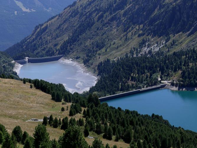
The payoff is the high-alpine basin around the Plan d'Amont dam, part of a hydroelectric system built between 1945 and 1956, with the edge of Vanoise National Park beyond it. Pavement ends at the car park and the last few hundred meters to the dam are gravel. There is no restaurant or bar at the top, and the Route des Barrages is closed to vehicles in winter, so this is a late-spring-to-autumn ride.
PLAN YOUR ROUTE
 We've partnered with Sherpa-Map.com to bring you the best route planning tool. With a PRO Membership you can use this climb as a reference when creating your route.
Montée du Barrage averages 7.3% over 12.1 km (7.5 mi), climbing 888.5 m (2,915 ft) from 1,157.6 m (3,798 ft) in Avrieux to 2,034.8 m (6,676 ft) at the upper dam car park.
The average hides how steady the effort is once you leave the valley floor. The steepest 0.5 km (0.3 mi) averages 10.8%, the steepest kilometer 10.1%, the steepest 2 km (1.2 mi) 9.9% and the steepest 5 km (3.1 mi) 9.3%. Even the steepest 10 km (6.2 mi) average 8.1%, so only about 2 km (1.3 mi) of the route is notably easier. Once the road turns onto the Route des Barrages there is little recovery, so pace the first hairpins and keep a low gear in reserve.
Roadway: The road is paved from Avrieux through to the upper car park below the dams, and riders have rated the asphalt average to good through 2025. The final stretch from the car park to the dam is unpaved gravel. The Route des Barrages (D108) is closed to vehicles each winter by departmental order to protect the road during freeze and thaw, and it is generally open from mid-May to mid-November depending on snow - the Aussois tourist office can confirm current access.
Traffic: Moderate in summer, with roughly 30 to 60 vehicles an hour on the upper road and only a handful of other cyclists. On selected summer mornings the HMV Cyclo Challenge closes the dam road to motor vehicles from 9:30 to 12:30, which makes for a much quieter ride - ask the Aussois tourist office for dates.
Parking: Avrieux is a small village, so park considerately around the village and do not block farm or residential access. The Marie-Thérèse redoubt in Avrieux has parking, public toilets and coach parking nearby. If you would rather drive up and ride the upper section only, there are several car parks near the dams at the end of the road.
Provisions: There is no restaurant or bar near the top of the climb, so carry the food and water you need from the valley. Aussois is the closest village for supplies.
Gear: You finish at over 2,000 m (6,562 ft), where it is noticeably cooler than in the Arc valley, so pack a light jacket for the descent. A compact or lower gearing is worth having for the 10% pitches. If you want to continue to the dam wall, the gravel finish is best done on foot or with wider tires.
Before heading out on any cycling adventure check out our Things to Bring on a Cycling Trip and use our interactive check list to ensure you don't forget anything.
Avrieux sits in the Haute-Maurienne at the foot of the Esseillon barrier, five forts built by the Kingdom of Sardinia in the early 19th century to guard the road to the Mont-Cenis pass. The Marie-Thérèse redoubt, in Avrieux itself, opened as a visitor centre in 2007 with a bilingual French-Italian museum and guided tours; it has typically been open daily in July and August and on limited days in June and September. A little higher in Aussois, Fort Marie-Christine overlooks the Arc valley, is free to visit and is open daily all year, with a restaurant and a gîte.
At the top, the Plan d'Aval lake is about 900 m long and holds trout, but swimming is prohibited because of strong changes in water level. The Plan d'Amont dam is about 350 m long, and the hiking trail around it enters Vanoise National Park, where dogs are not allowed even on a leash. Our Saint-André - l'Orgère page covers Modane as the valley's rail and lodging base, and our Montée d'Aussois (Modane) page covers the direct approach to Aussois from the valley floor. You can see other climbs nearby, or build a custom route from here, with our Routes in the Area tool.
ROUTE MAP

MEMBER RATING
CURRENT WEATHER
PJAMM TRIPS ADVENTURE STARTER BUNDLES
Check out PJAMM Adventure's prepackaged (self-guided) cycling trips. They will help you plan, document and conquer your next adventure.
NEARBY CLIMBS (0) RADIAL PROXIMITY
FROM No Climbs Found
MEMBER REVIEWS & COMMENTS
Let us know what you thought of this climb. Signup for our FREE membership to write a review or post a comment.
Already have an account?
LOG IN HERE
