La Sal Loop (Castle Valley) Bike Climb - PJAMM Cycling

7.8
FIETS
16.9 mi
DISTANCE
4,369 ft
GAINED
4.8 %
AVG. GRADE

FULL CLIMB STATS

Page Contributor(s): Chris Monson, Blanding, Utah, USA

INTRO

This is an “Oh My!” ride - it is spectacular. Come to Moab for the mountainbiking, stay for the roadbiking! We begin this climb 15 miles north of Moab on Highway 128 at the southeastern border of Arches National Park, and are treated immediately to colorful rock formations that have made Arches one of the most popular and scenic National Parks in the U.S. 
The climb averages 4.8% (5.1% with the minimal descent removed from the gradient equation).  The bulk of this climb fits into two gradient ranges: 8.9 miles (52.6% of the climb) at 0-5%, and seven miles (41.2%) at 5-10%.  Only 0.4 mile (2.7% of the climb) is between 10-15% and the grade never exceeds 15% at any time.  The steepest quarter-mile is 10.6% and the steepest continuous mile is at 8.2%.

See more details and tools regarding this climb's grade via the “Profile Tool” button.
Roadway:  Excellent condition.

Traffic:  Minimal.

Parking:  Great parking at the beginning of the climb - MapStreet View
Provisions:  This is a fairly remote climb with no food or water.

Weather:  It can be torturously hot in this area during the summer.  Consult the PJAMM "Full Forecast" feature for the time you expect to start and finish the climb to assess what clothing to bring on your ride.   Bring plenty of water. 
Before heading out on any cycling adventure check out our Things to Bring on a Cycling Trip and use our interactive check list to ensure you don't forget anything.
We stay in Moab for the La Sal and other bike climbs in this area.  There are also many unique options for vacation rentals in the area.  See our Moab Climb Area page for more details:  Moab, UT.  
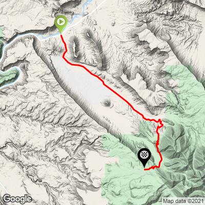
ROUTE MAP

MEMBER RATING

Difficulty: Challenging
4
Road
5
Traffic
4
Scenery

CURRENT WEATHER

PJAMM TRIPS ADVENTURE STARTER BUNDLES

Check out PJAMM Adventure's prepackaged (self-guided) cycling trips. They will help you plan, document and conquer your next adventure.
ALL TRIPS
Browse all of our prepackaged trips and find your next adventure!
The American Southwest
United States (AZ,NM,UT)
18 ROUTES
27 POIs
ROUTE STATS (TOTAL)
215.4
mi
DISTANCE
34,866
ft
ELEV. GAIN
Utah: Moab, Arches & Canyonlands
United States (UT)
19 ROUTES
21 POIs
ROUTE STATS (TOTAL)
325.3
mi
DISTANCE
32,871
ft
ELEV. GAIN
Utah: Zion National Park
United States (UT)
20 ROUTES
32 POIs
ROUTE STATS (TOTAL)
256.5
mi
DISTANCE
39,649
ft
ELEV. GAIN

NEARBY CLIMBS (0) RADIAL PROXIMITY

FROM
No Climbs Found

MEMBER REVIEWS & COMMENTS

Let us know what you thought of this climb. Signup for our FREE membership to write a review or post a comment.
Already have an account?

Jul 30, 2023
difficulty: Challenging
scenery: 4
traffic: 5
road: 4
Jul 30, 2023
scenery: 4
traffic: 5
road: 4
July 28, 2023 107° today so started the climb at 8am. A punchy climb to start and get your legs and lungs working then a long straight grind at 5 to 8% up to the right turn and the real climbing begins. Good roads and wonderful scenery. A big parking area with a grand view is the top - cooler at only 87°. A fast and friendly decent back to the bottom. For a harder workout, continue over the top and down to the bottom in Spanish Valley then climb back up. The road on this side is much steeper and a much harder climb on a not-so-good road with lots of bad pavement repairs, cracks, and holes. More great scenery !
Nov 28, 2021
difficulty: Challenging
scenery: 4
traffic: 5
road: 4
Nov 28, 2021
scenery: 4
traffic: 5
road: 4
Beautiful climb in the Moab area. The first 1.5 miles are steep and pretty tough, really gentle grade for the next 10 or so miles. A couple of really tough miles through the switchbacks up near the top. Weather on the mountain can change rapidly. Did this ride in November and it was VERY cold at the summit. Road has been replaced relatively recently, so great conditions.
ROUTE MAP
PROFILE TOOL
Route Data
S.G. (%)
hide
Segment Data
hide

Climb Profile Not Found
CLIMB SUMMARY

Cycling La Sal Loop Road at Castle Valley - bike parked on side of roadway overlooking scrub brush, and beyond red bluffs and canyons

Cycling La Sal Loop Road Utah, an exceptionally scenic bike climb.

Ride 16.9 miles gaining 4,411’ to elevation 8,337’ at 4.8% average grade.

US Top 10 Most Scenic Bike Climb.

This is an “Oh My!” ride -- it’s spectacular.  Come to Moab for the mountainbiking, stay for the road biking!

Cycling La Sal Loop Road at Castle Valley - photo collage, PJAMM Cycling logo in corner, bike parked against road signs for Castle Valley, La Sal Loop Road National Forest Access, scrub brush, large red bluff behind sign

Start of the climb.

Before heading to Moab on your cycling adventure, be sure to rely on our list of Things to Bring on a Cycling Trip, and use our interactive checklist to ensure you don't forget anything.

Cycling La Sal Loop Road at Castle Valley - informational signs at start of climb, PJAMM Cycling logo

La Sal Road Information Area, at the start of the climb.

We begin this climb 15 miles north of Moab on Highway 128 at the southeastern border of Arches National Park, and are treated immediately to colorful rock formations that have made Arches one of the most popular and scenic National Parks in the U.S.  For the first seven miles we are flanked by spectacular red sandstone bluffs, approaching, then passing at mile 4.5 the amazing natural wonder Castleton Tower, a 400’ red sandstone tower perched atop a 1,000 Moenkipi-Chinle cone (created as the sea receded millions of years ago from the Utah plains) this breathtaking and magnificent site alone is worth the trip!

Cycling La Sal Loop Road at Castle Valley - photo collage, PJAMM Cycling logo in corner, bike parked next to various road signs along climb's start

Road signs and views just past the start of the climb.

Cycling La Sal Loop Road at Castle Valley - PJAMM Cycling logo in corner, bike parked in front of sign for Castle Valley Farms "Sun-Fri Tomatoes, Beans, Cucumbers"

Castle Valley Farms at Mile 3, an Adventist academy and working farm.

Cycling La Sal Loop Road at Castle Valley - photo collage, PJAMM Cycling logo in corner, climb map and gradient, Garmin device and bike handlebars in center of roadway pointed toward red bluffs in distance, bike parked next to road signs, small red barn in field in distance, smiley face painted on asphalt

Photos along the first half of the climb.

Cycling La Sal Loop Road at Castle Valley - photo collage, PJAMM Cycling logo in corner, bike parked in front of various red bluffs, one of which is called The Rectory

Along the first part of the climb.

Upper left, lower left and lower right photos are of The Rectory, located just north of Castleton Tower.

Cycling La Sal Loop Road at Castle Valley - photo collage, PJAMM Cycling logo in corner, Castleton Tower

Photos of Castleton Tower taken from miles 3-6.

Cycling La Sal Loop Road at Castle Valley - PJAMM Cycling logo in corner, bike parked in center of two-lane roadway looking back toward Castleton Tower and The Rectory

Views back at Castleton Tower and The Rectory at mile 7.2.

There’s a lot of straight for the first half of this climb.


Cycling La Sal Loop Road at Castle Valley - photo collage, PJAMM Cycling logo in corner, bike parked in center of roadway near smiley face painted in roadway with asphalt sealer

There are a couple of Happy Faces placed on the roadway.

This photo is from mile 6.8 - left photo is view southeast of the roadway ahead.

Right photo is view northwest of the roadway we just climbed.

We bend right at mile 10.7 and continue on La Sal Loop Road (do not stay straight -- this takes you on the Dolores Triangle Safari Route).  Around this point, the surroundings begin to change with the classic Utah southeastern red bluffs giving way to an alpine setting (Pinyon and juniper trees, then oak and finally larger pines and aspen).  This climb takes us through the La Sal Mountains, the second highest mountain range in Utah.  While the La Sal Mountains top out just shy of 13,000’, the paved road (our route) tops out at 8,338’.  At about the 11 miles mark the pavement begins to show its wear (a bit deteriorated as of April 2016 -- common in remote Utah roads at snow level and above) and we experience alpine settings consistent with the Rocky Mountains.  

Cycling La Sal Loop Road at Castle Valley - bike parked in scrub brush next to "Road Narrows" road sign

Road narrows at mil 8.7.

Cycling La Sal Loop Road at Castle Valley - photo collage, PJAMM Cycling logo in corner, views from top of climb overlooking hillsides covered in low scrub brush and red canyons and bluffs beyond

Top left photo is from taken at the top of the climb.

Bottom left and side photos are taken about four miles from the top of the climb.

At mile 13 we enter Manti-La Sal National Forest and tackle the first of two sets of switchbacks (the second at mile 16).  These switchies offer us a good view back at the beautiful route we just travelled and just two more miles to the summit and finish of this spectacular climbing experience.

Cycling La Sal Loop Road at Castle Valley - yellow wildflowers in foreground with large wooden NPS sign reading "Entering Manti-LaSal National Forest"

Enter the National Forest at mile 12.4.

1,270,886 acres; established 1903 by Teddy Roosevelt.

Cycling La Sal Loop Road at Castle Valley - photo collage, PJAMM Cycling logo in corner, aerial views looking down from top of climb, winding roadway below with red bluffs in distance

Aerial views taken from the top of the climb. 

Steepest ¼ mile begins at mile 1.1 (10.5%) and steepest mile at 10.7 (8.2%).

Roadway surface and traffic:  Traffic is mild and the roadway surface is good, although it is a bit rough for the last few miles.  We rank this as a very safe ride.  There is a good parking at the beginning of La Sal Loop Road right off of Hwy 128

Castleton Tower Hike

This is a brute of a hike with great rewards for those that make it to the top.  Be sure to bring good hiking shoes because there are rough spots and some close to treacherous areas that require very good traction.  Here is the All Trails route we followed.

Cycling La Sal Loop Road at Castle Valley - informational sign at Castleton Tower Primitive Climber's Camp, PJAMM Cycling logo in corner

Cycling La Sal Loop Road at Castle Valley - gradient and map as seen on PJAMM adventure app

PJAMM Adventure App

Left Photo: That is one STEEP profile!!

Right Photo:  Ooops . . .

Cycling La Sal Loop Road at Castle Valley - photo collage, PJAMM Cycling logo in corner, views of Castleton Tower along hike, red dirt and low scrub brush, blue skies

Cycling La Sal Loop Road at Castle Valley - photo collage, PJAMM Cycling logo in corner, views along Castleton Tower climb, red dirt, red bluffs, hiker climbing over extremely rocky portion of trail, yellow PJAMM Cycling jersey draped over rocks

Cycling La Sal Loop Road at Castle Valley - photo collage, PJAMM Cycling logo in corner, views from Castleton Tower hike at sunset

La Sal Loop Road Out and Back from Castle Valley 

Continuing past the summit at about mile 18, we lightly descend for six miles down to Mill Creek Hydro Crag area at mile 23. Here, we are in a fascinating and beautiful glen that is a paradise to rock climbers.   Continuing on for another 15 miles we enter Spanish Valley, Utah -- the turnaround point for the out-and-back -- 77 miles, 9,100’ of climbing. Bring plenty of water and provisions because there are none along this route.  We advise caution and note that it is not advisable to do this route without SAG support during the summer).

An exceptional organized event that includes the La Sal Loop Road (Castle Valley) climb is the Moab Gran Fondo, which is held in the first Saturday in May each year (Moab Gran Fondo), usually attracting in the range of 500 or so riders.  This 65-mile course starts in Moab and features the Castle Valley Route summarized above, but instead of an out-and-back, this route is the full “loop” (the route is roughly outlined here: Map).  The event’s official website summarizes the ride as follows:

“The La Sal Mountain Loop Road features an amazing variety of canyon country scenery. The 65-mile long route follows the Colorado River for a while, then it heads to the La Sal Mountains through beautiful Castle Valley. The route through La Sals provides incredible views of the 12,000+ foot peaks and the red rock valleys far below. Finishing the loop takes one back to Moab via Spanish Valley Drive.”

That’s a wrap!!

Access to full Climb Summary requires a PJAMM Cycling PRO Membership!

It takes less than a minute to sign up & with your PRO membership you can:
  • Rate climbs, post comments and share your experiences on any of our climb pages
  • Create bucket lists of climbs & mark the dates you complete them
  • Weather data for all climbs - Start & Finish
  • Upload photos to your member page to customize your PJAMM Cycling experience
  • Utilize all of our interactive tools - Profile & Routes in Area
  • Download climb route .gpx files
LEARN MORE
SIGN UP

Already have an account? LOG IN HERE