
21.6
PDI
9.1 mi
DISTANCE
3,363 ft
GAINED
7 %
AVG. GRADE
FULL CLIMB STATS
INTRO
PLAN YOUR ROUTE
 We've partnered with Sherpa-Map.com to bring you the best route planning tool. With a PRO Membership you can use this climb as a reference when creating your route.
 Col d'Albanne averages 7.0% over 14.6 km (9.1 mi). The steepest 10 km (6.2 mi) average 8.1%, the steepest 5 km (3.1 mi) 8.8%, the steepest 2 km (1.2 mi) 9.4% and the steepest kilometre 10.1%, with the steepest half kilometre (0.3 mi) at 10.6% and the steepest 100 yards (91 m) at 14.9%.
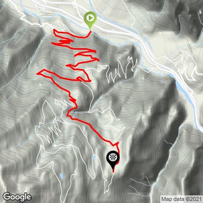
The grade is demanding but regular, with no real flat sections in the first two-thirds of the climb. The steep opening on the cliff-cut road is where most riders feel it, and after that the effort is steady and the forest shade helps.
Roadway: The road is paved the whole way. The lower section is narrow and cut into the cliff, and the upper kilometres have somewhat grainy, patchy pavement, so take care on the descent.
Traffic: Light. Riders report little traffic, and it is almost entirely local. If you are riding from Saint-Jean-de-Maurienne to the start, the D81 avoids the heavier D1006 valley road.
Parking: Le Bochet is at the valley floor near industrial areas, so the practical option is Saint-Jean-de-Maurienne, roughly 6 km (3.7 mi) down the valley, where our Croix de Fer page has the street-parking details, and ride out to the start.
Gear: A compact chainset is enough for 7.0% average, and a standard road bike is fine. Wider tyres help on the rougher upper pavement.
Provisions: Fill your bottles in the valley. There are hotels at Montricher and at Les Karellis for a stop, but the climb itself has few services, and the north-facing forest is cool, so bring a layer for the descent.
Before heading out on any cycling adventure check out our Things to Bring on a Cycling Trip and use our interactive check list to ensure you don't forget anything.
The climb runs through the hamlets of the commune of Montricher-Albanne: Montricher at about 1,200 m, Albannette at 1,400 m and Albanne at 1,630 m, with the Les Karellis ski station, established in 1975, close by. Lac de Pramol at the top has benches and picnic tables, and the view from there takes in the Croix des Têtes, a rocky peak with two summit humps that dominates the Encombres massif.
Saint-Jean-de-Maurienne is the valley hub, and our Croix de Fer page covers the town. For more Maurienne climbs nearby, including the Col du Mollard, Col du Sapey and La Toussuire, see other climbs nearby, or build a custom route from here, with our Routes in the Area tool.
ROUTE MAP
MEMBER RATING
CURRENT WEATHER
PJAMM TRIPS ADVENTURE STARTER BUNDLES
Check out PJAMM Adventure's prepackaged (self-guided) cycling trips. They will help you plan, document and conquer your next adventure.
NEARBY CLIMBS (0) RADIAL PROXIMITY
FROM No Climbs Found
MEMBER REVIEWS & COMMENTS
Let us know what you thought of this climb. Signup for our FREE membership to write a review or post a comment.
Already have an account?
LOG IN HERE
