
20.8
PDI
9.9 mi
DISTANCE
3,467 ft
GAINED
6.3 %
AVG. GRADE
FULL CLIMB STATS
INTRO
PLAN YOUR ROUTE
 We've partnered with Sherpa-Map.com to bring you the best route planning tool. With a PRO Membership you can use this climb as a reference when creating your route.
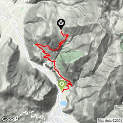
 Col du Chaussy from Hermillon averages 6.3% over 15.9 km (9.9 mi), climbing 1057 m (3,467 ft) from 529 m (1,734 ft) to the col at 1533 m (5,029 ft). About 53 m (173 ft) of descent along the way, mostly near Le Châtel, means the net gain is slightly less than the total climbed.
The steepest 100 yards (91 m) reach 14.3% and the steepest quarter mile (0.4 km) averages 13.1%. Over longer stretches the steepest half mile (0.8 km) averages 9.8%, the steepest mile (1.6 km) 8.2%, and the steepest 5 km (3.1 mi) 7.8%.
Roadway: Paved to the col and in good condition overall. The lower hairpins to Montvernier are wide and rougher, while above Montpascal the road narrows, runs along a cliff-cut section with a drop on one side, and needs more care. Take extra care on the descent. The col is a Nordic ski area in winter, so expect snow and frost on the upper road outside summer.
Traffic: Mostly light. You share the road with local cars in the villages, and the narrow upper road under the cliffs sees very little traffic.
Parking: Hermillon is a small village, so parking is limited. The easiest option is to park in Saint-Jean-de-Maurienne, where there is street parking near the center, and ride the 3 km (1.9 mi) approach to the Hermillon roundabout.
Provisions: Drinking fountains in Hermillon are a good place to fill bottles before the climb, and Montvernier, roughly 6 km (3.7 mi) up, is another water stop. An inn at the col offers a place to regroup, though opening times vary, so carry food.
Weather: The col is only 1533 m (5,029 ft), but afternoon heat on the open lower slopes and cooler air at the top can differ noticeably, so carry a light layer for the descent.
Before heading out on any cycling adventure check out our Things to Bring on a Cycling Trip and use our interactive check list to ensure you don't forget anything.
The Tour de Bérold, a 15 m (48 ft) square keep with walls about 20 m (66 ft) high, stands on a promontory about 1 km (0.6 mi) from the village of Le Châtel, which you pass on this climb. It is a listed historic monument, probably dating to the 9th century, and is associated with Bérold de Saxe, an ancestor of the House of Savoy. Entry to the site is free and it is open year-round.
For a loop, climb the Hermillon side and descend through the Lacets de Montvernier, or ride the other direction; our Col du Chaussy - Lacets de Montvernier page covers the hairpins and a tourism-office loop, and our Col du Chaussy (La Chambre) page describes the north side. Saint-Jean-de-Maurienne is the valley's climbing hub, and our Col de la Croix de Fer (Saint-Jean-de-Maurienne) page covers the town.
Our Routes in the Area tool lists the other climbs around Saint-Jean-de-Maurienne.
ROUTE MAP
MEMBER RATING
CURRENT WEATHER
PJAMM TRIPS ADVENTURE STARTER BUNDLES
Check out PJAMM Adventure's prepackaged (self-guided) cycling trips. They will help you plan, document and conquer your next adventure.
NEARBY CLIMBS (0) RADIAL PROXIMITY
FROM No Climbs Found
MEMBER REVIEWS & COMMENTS
Let us know what you thought of this climb. Signup for our FREE membership to write a review or post a comment.
Already have an account?
LOG IN HERE
