
18.9
PDI
8.5 mi
DISTANCE
3,036 ft
GAINED
6.7 %
AVG. GRADE
FULL CLIMB STATS
INTRO
La Toussuire (Route du Centre) is the Saint-Pancrace way up to the La Toussuire ski resort: 13.7 km (8.5 mi) from Pierrepin on the Croix de Fer road, gaining 925 m (3,036 ft) at a 6.7% average from 796 m (2,610 ft) to the resort at 1708 m (5,603 ft). Instead of the main D78 through Fontcouverte and Le Corbier, it turns off the D926 onto the Route du Centre through Saint-Pancrace, a small commune on the hillside above Saint-Jean-de-Maurienne, then climbs to the resort village of Les Bottières before joining the main road at La Rochette.
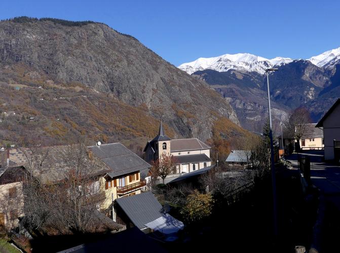
The hard part comes first. The opening 5 km (3.1 mi) through Saint-Pancrace and up toward Les Bottières hold a steady 8-9%, and the steepest kilometer averages 9.5%. Around Les Bottières the road levels out for about a kilometer as it traverses the slope - a real breather - before another steep kilometer and a second easy stretch past L'Alpettaz. The last 4 km (2.5 mi) on the D78 from La Rochette climb at 5.5-9% before the grade eases off into the resort. Les Bottières is known as a balcony village, and the road lives up to it, with wide views over the Maurienne valley and, from the village, across to the Aiguilles d'Arves.
La Toussuire has hosted three Tour de France stage finishes, in 2006, 2012 and 2015 - our La Toussuire (Saint Jean de Maurienne) page covers that history and the main D78 approach through Fontcouverte. This page covers the Saint-Pancrace alternative: a route with more village character and a two-stage profile that rewards riders who pace the steep opening.
PLAN YOUR ROUTE
 We've partnered with Sherpa-Map.com to bring you the best route planning tool. With a PRO Membership you can use this climb as a reference when creating your route.
La Toussuire (Route du Centre) climbs 13.7 km (8.5 mi) from 796 m (2,610 ft) to 1708 m (5,603 ft), gaining 925 m (3,036 ft) at a 6.7% average. That average hides a split profile. The first 5 km (3.1 mi), on the D78C through Saint-Pancrace and the D78D toward Les Bottières, run at 8-9% with no letup: the steepest 5 km average 8.5%, the steepest 2 km 9.0% and the steepest kilometer 9.5%. The steepest mile averages 9.3%, and the steepest 100 yards reach 10.7%.
Two near-flat kilometers follow - one around Les Bottières at about 1% and another past L'Alpettaz at about 1.4% - separated by a kilometer at roughly 8%. From La Rochette, the D78 climbs at 5.5-8.8% for about 4 km (2.5 mi), and the final stretch into La Toussuire eases to under 3%.
Roadway: Paved the entire way. The D78C and D78D are narrower village roads serving Saint-Pancrace and Les Bottières, while the final 4 km (2.5 mi) are on the D78, the main resort road into La Toussuire. Several minor roads branch off between the villages, and riders report it's easy to take a wrong turn, so load a GPS file before you go. The descent can be slippery in the rain, and strong wind on the open upper slopes is worth respecting.
Traffic: The route leaves the busy D926 right at the start, and the village roads through Saint-Pancrace and Les Bottières mostly carry local and resort traffic. Riders report noticeably heavier traffic once the route meets the D78 below La Toussuire, so expect more cars on the final 4 km (2.5 mi).
Parking: Pierrepin is a roadside hamlet on the main Croix de Fer road, so the simplest option is to park in Saint-Jean-de-Maurienne (town-center parking is covered on our Col de la Croix de Fer (Saint-Jean-de-Maurienne) page) and ride about 4 km (2.5 mi) up the D926 to the turnoff. If you'd rather start higher, Les Bottières, about 5 km (3.1 mi) into the climb, is a small resort village that makes a natural meeting point for a support car.
Provisions: Les Bottières, roughly 5-7 km (3.1-4.3 mi) in, is the only village with services on the way up - in summer its two bar-restaurants are La Corbacière, with a sunny terrace, and Le Grenier, which serves regional food. Otherwise, fill bottles in Saint-Jean-de-Maurienne before you start; La Toussuire has full resort services at the top.
Gear: The opening 5 km (3.1 mi) at 8-9% come before you've had a chance to settle in, so a compact crankset with a 28-30 tooth low cog is a sensible choice. The lower slopes are exposed to the sun - riders have recorded temperatures near 39°C (102°F) on an August afternoon - so start early on a hot day, and carry a wind layer for the 925 m (3,036 ft) descent.
Before heading out on any cycling adventure check out our Things to Bring on a Cycling Trip and use our interactive check list to ensure you don't forget anything.
Saint-Pancrace is the first village you reach, about 1.5 km (0.9 mi) up, and the Route du Centre that gives this climb its name runs right through it, past the town hall and parish church. Higher up, Les Bottières is a small resort village of traditional chalets, linked into the Les Sybelles ski area, and a quiet base if you'd like to stay above the valley.
If you have time off the bike, the signed Les Bottières discovery trail is an easy 1.8 km (1.1 mi) loop of about an hour from the tourist office. It passes the Baroque chapel of Saint Bernard de Menthon, with its viewpoint on the Aiguilles d'Arves, an orientation table that names the surrounding peaks, and the small Lac du Lou, a good picnic stop; a variant leads to the hamlet of Les Colonnes and its panoramic view of the valley. The tourist office's La Toussuire via Jarrier route joins this climb at Les Bottières, so it's easy to come up one way and descend the other.
For the resort itself, Fontcouverte and Le Corbier, see our La Toussuire (Saint Jean de Maurienne) page; for the Opinel museum and Saint-Jean-de-Maurienne, see our Col de la Croix de Fer (Saint-Jean-de-Maurienne) page. See other climbs nearby, or build a custom route from here, with our Routes in the Area tool.
ROUTE MAP

MEMBER RATING
CURRENT WEATHER
PJAMM TRIPS ADVENTURE STARTER BUNDLES
Check out PJAMM Adventure's prepackaged (self-guided) cycling trips. They will help you plan, document and conquer your next adventure.
NEARBY CLIMBS (0) RADIAL PROXIMITY
FROM No Climbs Found
MEMBER REVIEWS & COMMENTS
Let us know what you thought of this climb. Signup for our FREE membership to write a review or post a comment.
Already have an account?
LOG IN HERE
