

20.6
PDI
11 mi
DISTANCE
3,554 ft
GAINED
6 %
AVG. GRADE
FULL CLIMB STATS
Page Contributor(s): Lisa Irizarry and Matt Jiang, NY, NY
INTRO
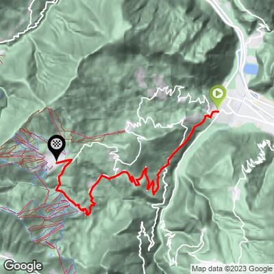
La Toussuire climbs 17.7 km (11.0 mi) from Saint-Jean-de-Maurienne in the Maurienne valley, gaining 1,083 m (3,554 ft) at a 6.0% average grade from 618 m (2,029 ft) to the ski resort plateau at about 1,684 m (5,524 ft). The first stretch shares the D926 with the Col de la Croix de Fer road; about 5 km (3.1 mi) out, the route turns onto the D78 and climbs through Fontcouverte and Villarembert to the big resort of Le Corbier before easing across to La Toussuire.
It is a long, regular climb rather than a brutal one: the steepest mile averages 8.2%, and the final 2.6 km (1.6 mi) into the resort is a gentle boulevard. Little of it has shade, so heat is the main challenge on a summer day.
The Tour de France has finished here three times: in 2006 Michael Rasmussen won the stage on the day Floyd Landis collapsed, in 2012 Pierre Rolland won the stage from Albertville, and in 2015 Vincenzo Nibali won Stage 19 from Saint-Jean-de-Maurienne.
PLAN YOUR ROUTE
 We've partnered with Sherpa-Map.com to bring you the best route planning tool. With a PRO Membership you can use this climb as a reference when creating your route.
 La Toussuire gains 1,083 m (3,554 ft) over 17.7 km (11.0 mi), climbing from 618 m (2,029 ft) in Saint-Jean-de-Maurienne to about 1,684 m (5,524 ft) at the resort, a 6.0% average grade.
The steepest mile averages 8.2%, the steepest kilometer 8.4% and the steepest half kilometer 8.6%, and the steepest 100 yards reach 8.9%. The steepest 5 km average 7.0%. That is very even for an Alpine climb of this length. Riders describe a hard start of about 7-9% on the D926 before the junction, a steady 6-7% through Fontcouverte and Villarembert, a short steeper section up to Le Corbier, and a final gentle stretch under 5% into La Toussuire.
Roadway: The road is paved the entire way and, as a Tour de France route, is generally well maintained. Riders in 2023 called the surface good to excellent, though one earlier report noted a poor patch. The route is marked with signs showing the slope, altitude and distance to the top. Signposting at the turn onto the D78 is easy to miss, so follow the route markers or a GPS file.
Traffic: Light once you leave the D926, which is shared with Croix de Fer traffic for the first 5 km (3.1 mi). Le Corbier and La Toussuire are busy with tourists in summer.
Parking: Saint-Jean-de-Maurienne is the valley's hub town, with street parking near the center close to the start, as described on our Col de la Croix de Fer (Saint-Jean-de-Maurienne) page. The start point is on the Place de la Cathédrale.
Provisions: There is a public fountain in the center of Fontcouverte, roughly 10 km (6.2 mi) into the climb, which riders use to drink and cool off. The lower climb is fully exposed and can be very hot, and one rider suggests riding in the afternoon because the morning sun can wash out the views, though the heat is real. Services are available in the resort at the top.
Gear: A standard compact is sufficient, since the grade rarely goes beyond 8-9%. Bring sun protection, and a light jacket for the descent, which loses about 1,070 m (3,510 ft).
Before heading out on any cycling adventure check out our Things to Bring on a Cycling Trip and use our interactive check list to ensure you don't forget anything.
Fontcouverte is worth noticing on the way up: barns in the village are painted with Tour de France jerseys, and its fountain is the best refill point on the climb. Villarembert and Le Corbier follow; Le Corbier is a large purpose-built resort linked to La Toussuire through the Les Sybelles ski area, and it is very busy in summer. La Toussuire itself sits on a sunny plateau at around 1,750 m (5,741 ft) with views of the Aiguilles d'Arves (highest point 3,514 m / 11,529 ft). Bike rental is available in the resort. Near the end, riders suggest taking the second left turn to reach the wooden cyclist landmark.
The marked route is open from 15 March to 30 October. Another way up leaves the main route at Le Villard about 10 km (6.2 mi) in and goes via La Rochette and Les Anselmes for a shorter, steeper climb of roughly 15.3 km (9.5 mi); our La Toussuire (Route du Centre) page also covers a separate approach. For Opinel knives and the town itself, see our Col de la Croix de Fer (Saint-Jean-de-Maurienne) page.
The resort is around 1,000 m (3,281 ft) above the valley, so conditions can differ sharply from Saint-Jean-de-Maurienne - check our Weather tool before you go.
ROUTE MAP
MEMBER RATING
CURRENT WEATHER
PJAMM TRIPS ADVENTURE STARTER BUNDLES
Check out PJAMM Adventure's prepackaged (self-guided) cycling trips. They will help you plan, document and conquer your next adventure.
NEARBY CLIMBS (0) RADIAL PROXIMITY
FROM No Climbs Found
MEMBER REVIEWS & COMMENTS
Let us know what you thought of this climb. Signup for our FREE membership to write a review or post a comment.
Already have an account?
LOG IN HERE
