
16.8
PDI
6.6 mi
DISTANCE
2,556 ft
GAINED
7.4 %
AVG. GRADE
FULL CLIMB STATS
INTRO
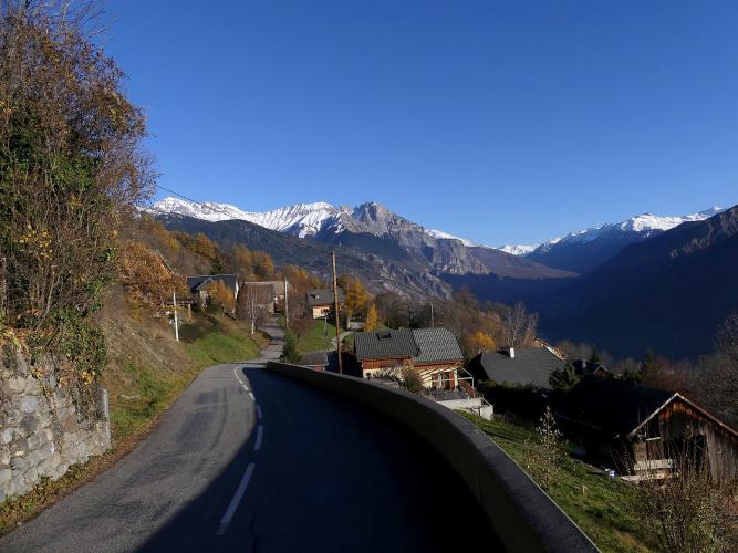
Most riders leaving Saint-Jean-de-Maurienne point their wheels at the Croix de Fer or La Toussuire and never notice the small sign for Jarrier. Take it, and within a few minutes you're stacking up switchbacks on a south-facing slope, with the town's rooftops shrinking below you at every bend and the Maurienne valley opening out both ways.
The climb runs 10.6 km (6.6 mi) from the edge of town to the Parking du Léard, gaining 779 m (2,556 ft) at 7.4%, and it never once goes downhill. The work is front-loaded: the hairpins up through Mollard-Rocher to Jarrier sit at 7.5 to 9%, and the kilometer just below the village is the steepest of the day. Past Jarrier the Route du Léard settles to 6-7% and strings together the hamlets of La Curtaz, Varcinières and Le Mollard, with the Aiguilles d'Arves coming into view as you gain height.
There's almost no shade. The road faces south and runs through hamlets and open slopes rather than forest, which makes it a poor choice on a July afternoon and a very good one in March or late October, when this hillside can feel a season warmer than the valley floor. It ends at a trailhead car park at 1410 m, where walkers set off for the Chambeaux chapel - and where riders report toilets and a water point, which is more than most climbs this size can offer.
PLAN YOUR ROUTE
 We've partnered with Sherpa-Map.com to bring you the best route planning tool. With a PRO Membership you can use this climb as a reference when creating your route.
The climb averages 7.4% over 10.6 km (6.6 mi), from 631 m (2,070 ft) in Saint-Jean-de-Maurienne to 1410 m (4,626 ft) at the Parking du Léard, with no descent at all.
The first 5 km (3.1 mi) carry the work: 7.7% for the opening kilometer out of town, 8.1% for the second, 7.5% through the bends at Mollard-Rocher, then 8.3% and 9.0% for kilometers 4 and 5 up to Jarrier. The steepest kilometer (9.1%), the steepest 2 km (8.9%) and the steepest 500 m (10.1%) are all on that lower half, and the steepest 5 km average 8.1%.
Above Jarrier the Route du Léard is kinder: kilometers 6 to 10 run between 5.9% and 7.2%, and the last 600 m (0.4 mi) to the car park tick back up to about 7.4%. Pace the switchbacks sensibly and the top half is where you find a rhythm.
Roadway: Asphalt from start to finish. The switchbacks between town and Jarrier have a good surface; above the village riders say the pavement gets rougher, though the road stays wide enough for a car to pass a bike comfortably right up to the car park.
Traffic: Light. You're on the Croix de Fer road for only a moment before the Jarrier turn, and after that the road serves the commune's scattered hamlets, so most cars belong to residents or to hikers heading for the trailhead at the top. Expect a few more of those on fine summer weekends.
Parking: Park in Saint-Jean-de-Maurienne and ride out - the start is on the southern edge of town, and our Col de la Croix de Fer (Saint-Jean-de-Maurienne) page covers town-center parking. For a support car or a picnic at the finish, the free Parking du Léard at the top of the road is the trailhead for the Chambeaux chapel walk.
Provisions: Fill up in Saint-Jean-de-Maurienne. Riders report a water point and toilets at the Parking du Léard, but there's nowhere obvious to buy food once you've left town, so carry what you'll need.
Gear: The lower half holds 8-9% for long stretches, so a compact with a 30-tooth cog makes the switchbacks to Jarrier far more pleasant. Sunscreen matters more than layers on this side of the valley, but the finish is almost 800 m above town - bring a vest for the descent in spring and autumn.
Before heading out on any cycling adventure check out our Things to Bring on a Cycling Trip and use our interactive check list to ensure you don't forget anything.
If you have legs left at the top, walk up to Notre-Dame des Chambeaux: a signed 4.6 km (2.9 mi) out-and-back from the Parking du Léard to the chapel at 1726 m (5,663 ft), on a wide path with a view over the whole valley. The first chapel went up in 1864; a storm flattened it in 1935, and the parishioners rebuilt it in 1941.
You can also sleep up here rather than in town. The Chalet de la Tuvière, a bike-friendly B&B at about 1400 m in Jarrier, has secure bike parking and basic repair tools, and does half-board.
Jarrier is on the tourist office's La Toussuire via Jarrier route, which carries on to meet the Saint-Pancrace road at Les Bottières - 17.9 km (11.1 mi) to the resort with 1296 m (4,252 ft) of climbing. Our La Toussuire (Route du Centre) page covers Les Bottières, and Saint-Jean-de-Maurienne itself, Opinel museum included, is on our Col de la Croix de Fer (Saint-Jean-de-Maurienne) page.
ROUTE MAP

MEMBER RATING
CURRENT WEATHER
PJAMM TRIPS ADVENTURE STARTER BUNDLES
Check out PJAMM Adventure's prepackaged (self-guided) cycling trips. They will help you plan, document and conquer your next adventure.
NEARBY CLIMBS (0) RADIAL PROXIMITY
FROM No Climbs Found
MEMBER REVIEWS & COMMENTS
Let us know what you thought of this climb. Signup for our FREE membership to write a review or post a comment.
Already have an account?
LOG IN HERE
