
17.9
PDI
6.1 mi
DISTANCE
2,581 ft
GAINED
8.1 %
AVG. GRADE
FULL CLIMB STATS
INTRO
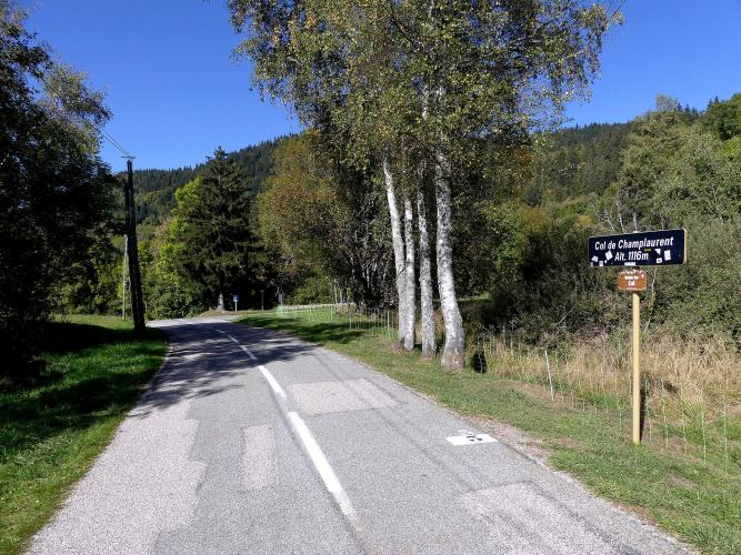
The Col de Champlaurent (often written Col de Champ-Laurent) climbs 9.8 km (6.1 mi) from Chamoux-sur-Gelon, gaining 787 m (2581 ft) at an 8.1% average to the col at 1105 m (3626 ft). It crosses the northern tail of the Belledonne range, linking the Val Gelon with the high, marshy Vallée des Huiles and the Col du Grand Cucheron. There are around nine paved ways to the top, and this side from Chamoux is the best known.
What defines it is how relentlessly even it is. The D25 rarely drops below 8%, the only real breather comes around the 3 km mark, and some 14 hairpins stack up through mostly wooded slopes, so much of the climb is shaded. It is also close to traffic-free - on a mid-August ascent one rider counted five to ten cyclists for every car.
Near the top the road runs through Champ-Laurent, a hamlet-sized commune of about 31 residents, with a short, steep ramp between the houses before the grade relents for the final kilometer. Views of the Lauzière and Belledonne ranges open up near the col, and from there you can drop into the Vallée des Huiles and climb back out over the Col du Grand Cucheron for one of the best quiet loops in this corner of Savoie.
PLAN YOUR ROUTE
 We've partnered with Sherpa-Map.com to bring you the best route planning tool. With a PRO Membership you can use this climb as a reference when creating your route.
The Col de Champlaurent from Chamoux-sur-Gelon is 9.8 km (6.1 mi) long with 787 m (2581 ft) of climbing at an 8.1% average, from 319 m (1045 ft) to 1105 m (3626 ft).
The grade is remarkably consistent. The first 2 km average about 8.3%, kilometer 3 eases to 6.6% - the only real recovery on the climb - and from there the road settles back into 8-9% for five more kilometers. The hardest stretch runs from about km 5 to km 8 at close to 9%, peaking at 9.3% for kilometer 8 as you approach Champ-Laurent, where a short ramp through the village is steeper still. Past the village, the last 1.5 km ease to 6-7.5% into the col.
Steepest sections: 9.4% for the steepest kilometer, 9.2% for the steepest 2 km and 8.7% for the steepest 5 km. The steepest mile (1.6 km) averages 9.2%. The climb is currently ranked #1244 in the world in our database.
Roadway: The D25 is paved all the way to the col, and riders consistently rate the surface as good. Loose gravel can collect on the hairpins, especially in spring and after storms, so stay alert on the way down. The road is narrow above the valley and winds through about 14 hairpins, mostly in forest - take the descent at a controlled pace.
Traffic: Very light. The D25 serves only Champ-Laurent and a few scattered farms, and riders regularly report meeting more cyclists than cars - on a summer morning you may share the road with a handful of other riders and almost no motor traffic.
Parking: The climb shares its start with the Fort de Montgilbert road, so the same free parking around the church square in Chamoux-sur-Gelon works here. Arriving by train is easy too: Chamousset station, on the Chambéry-Modane TER line, is in the neighboring village, a short ride from the start. Champ-Laurent itself is tiny and has no services, so plan on starting from the valley.
Provisions: Stock up in Chamoux-sur-Gelon before you start - there are no shops or cafes on the climb, and Champ-Laurent has no services. The one useful stop on the way up is a drinking-water fountain on the right as you pass through Champ-Laurent, which riders describe as fresh and cold.
Gear: Nearly 10 km at a steady 8-9% calls for a compact crankset with a 30- to 32-tooth cog at the back. The forest keeps the road shaded for much of the day, but the descent is long and steep, so pack a light layer for the trip back down.
Before heading out on any cycling adventure check out our Things to Bring on a Cycling Trip and use our interactive check list to ensure you don't forget anything.
Champ-Laurent is one of the smallest communes in Savoie - about 31 residents spread over a steep slope that runs from 520 m to 1337 m (1706-4386 ft) - and riding through it is the climb's most memorable moment: a cluster of old farmhouses, the small Église Saint-Blaise and the village fountain, then the forest again.
Over the col, the road drops about 3.5 km into the Vallée des Huiles around Bourget-en-Huile, a quiet green valley at the foot of the Belledonne. Its centerpiece is the Marais du Haut-Gelon (Marais du Pontet), a high wetland that was drained in the 1980s and restored in the 2000s. An interpretive trail with a wooden boardwalk and a wildlife hide crosses it - look for the whinchat and the rare fen orchid. From the valley floor it's about 3.5 km back up to the Col du Grand Cucheron, which makes the classic Champlaurent-Cucheron loop.
Fort de Montgilbert starts from the same square in Chamoux, so a double-header is easy, and our Fort de Montgilbert page covers the village's bakery and shops.
ROUTE MAP

MEMBER RATING
CURRENT WEATHER
PJAMM TRIPS ADVENTURE STARTER BUNDLES
Check out PJAMM Adventure's prepackaged (self-guided) cycling trips. They will help you plan, document and conquer your next adventure.
NEARBY CLIMBS (0) RADIAL PROXIMITY
FROM No Climbs Found
MEMBER REVIEWS & COMMENTS
Let us know what you thought of this climb. Signup for our FREE membership to write a review or post a comment.
Already have an account?
LOG IN HERE
