
23.3
PDI
8 mi
DISTANCE
3,378 ft
GAINED
7.9 %
AVG. GRADE
FULL CLIMB STATS
INTRO
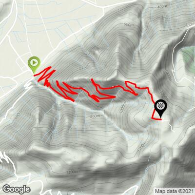
Fort de Montgilbert climbs 12.9 km (8 mi) from Chamoux-sur-Gelon, in the Val Gelon of Savoie, gaining 1030m (3,378 ft) at an average grade of 7.9% to the end of the paved road at 1354m (4,442 ft), a few minutes' walk below an abandoned 19th-century mountain fort. It's a dead-end, out-and-back climb on the northern tail of the Belledonne range - part of the same cluster of tough, little-known Savoie ascents as the Col de Champlaurent, the Col du Grand Cucheron, and Val Pelouse.
What sets this one apart is how consistently hard and how quiet it is. The first 7 km (4.3 mi) switchback up the D26 to the village of Montendry at a near-constant 8%, with occasional glimpses of the Dent d'Arclusaz and the valley below. Above Montendry the road narrows into a forest lane that holds 8-9% for several more kilometers, easing only over the final 3 km (1.9 mi). Seventeen hairpins pace the ascent, and you'll share the road mostly with the odd paraglider shuttle heading for the launch site near the top.
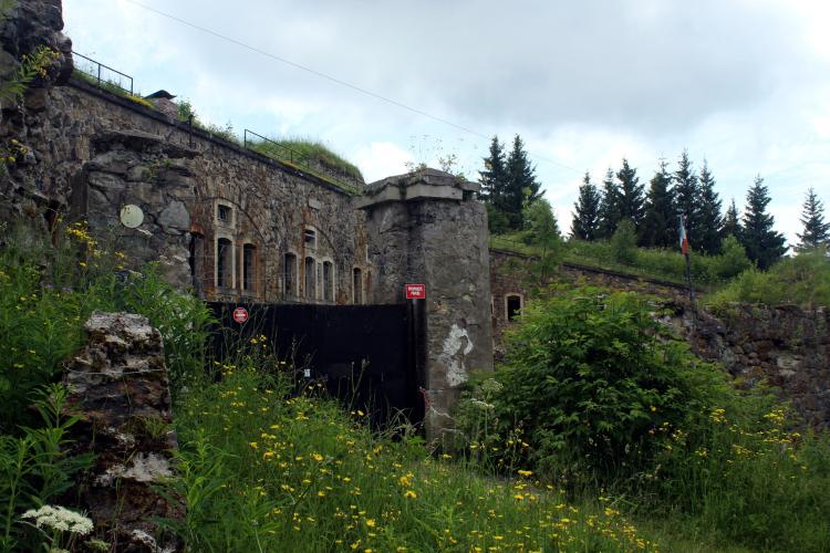
The payoff is Fort de Montgilbert itself, built between 1877 and 1883 as part of the Séré de Rivières system of forts that France built after the Franco-Prussian War - this one to guard the entrance to the Maurienne valley and the approaches to the Fréjus rail tunnel. The fort is off-limits to visitors today, but its stone walls are a short walk from the road's end in the forest. With so many other climbs radiating from Chamoux and nearby La Rochette, see other climbs nearby, or build a custom route from here, with our Routes in the Area tool.
PLAN YOUR ROUTE
 We've partnered with Sherpa-Map.com to bring you the best route planning tool. With a PRO Membership you can use this climb as a reference when creating your route.
 Fort de Montgilbert climbs 12.9 km (8.0 mi) from 337 m (1,107 ft) in Chamoux-sur-Gelon to 1354 m (4,442 ft) at the end of the paved road, gaining 1030 m (3,378 ft) at an average grade of 7.9%.
There's almost no respite. The first 7 km (4.3 mi) to Montendry average about 8%, with only one easier kilometer (around 5.7%) about 4 km in. Above Montendry, the next 3 km (1.9 mi) are the hardest sustained stretch of the climb at close to 9%, including a kilometer at about 9.5%. The last 3 km (1.9 mi) ease to roughly 7%.
The steepest 0.5 km (0.3 mi) averages 12.0%, the steepest kilometer 10.6%, the steepest 2 km (1.2 mi) 9.6%, and the steepest 5 km (3.1 mi) 8.9%.
Roadway: The D26 is paved and in good condition from Chamoux-sur-Gelon to Montendry. Above the village the route continues on a narrower, paved forest road that was resurfaced in 2012-2013 but often carries loose gravel, twigs, and mud, and is crossed by roughly thirty metal water-drainage channels over its upper 6 km. They're easy enough to ride over going uphill but demand real care on the descent - take it slowly and cross them square-on.
Traffic: Very light. The D26 serves only Montendry and a few hamlets, and above the village you're likely to meet little more than the occasional van shuttling paragliders to their launch site near the top. Sheep graze the upper slopes in summer, guarded by livestock dogs - slow down, give the flock space, and don't approach the dogs.
Parking: Chamoux-sur-Gelon is a quiet village in the Val Gelon, and there's free street parking around the Place de l'Église at the start. At the top, the paved road ends at a small hikers' parking area in the forest.
Provisions: Chamoux-sur-Gelon has what you need at the start: the Aux Amoureux du Pain bakery right on the Place de l'Église (closed Mondays), plus a butcher, cheese shop, bar-restaurant, and pizzeria in the village. There are no shops or cafes on the climb itself or at the top, so carry enough water and food for the full out-and-back.
Gear: With close to 13 km of 8-9% and a 12% pitch along the way, a compact crankset with a wide-range cassette is the sensible choice. Good brakes matter here too - the descent is long, steep, and interrupted by drainage channels, so check your pads before you go. The lower slopes are shaded in the morning, making an early start the more comfortable option on hot days.
Before heading out on any cycling adventure check out our Things to Bring on a Cycling Trip and use our interactive check list to ensure you don't forget anything.
Fort de Montgilbert was one of a trio of "low-mountain" forts - with Aiton and Chamousset - that closed off the entrance to the Maurienne valley in the late 1800s. Built between 1877 and 1883 on a triangular, single-crest plan, it had room for 749 men, its own bakery, and a concrete optical signal post for communicating with Fort de Montperché and Grenoble. It was never modernized, and today it's managed by a shooting club and closed to the public, so enjoy it from the outside - the short walk from the road's end is worth it just to see the scale of the walls.
Chamoux-sur-Gelon is also the start of the Col de Champlaurent - the two roads split just outside the village - so it's easy to pair the two on the same day. Val Pelouse, the Col du Grand Cucheron, and the Col du Frêne are all a short drive away, which makes the Val Gelon and nearby Valgelon-La Rochette a good, uncrowded base for a few days of hard Savoie climbing.
ROUTE MAP
MEMBER RATING
CURRENT WEATHER
PJAMM TRIPS ADVENTURE STARTER BUNDLES
Check out PJAMM Adventure's prepackaged (self-guided) cycling trips. They will help you plan, document and conquer your next adventure.
NEARBY CLIMBS (0) RADIAL PROXIMITY
FROM No Climbs Found
MEMBER REVIEWS & COMMENTS
Let us know what you thought of this climb. Signup for our FREE membership to write a review or post a comment.
Already have an account?
LOG IN HERE
