
15.5
PDI
6.9 mi
DISTANCE
2,500 ft
GAINED
6.9 %
AVG. GRADE
FULL CLIMB STATS
INTRO
Moûtiers is where everyone turns up the valley for Val Thorens, Courchevel or Méribel, and on a summer morning the D117 out of town is a line of cars and coaches. Hautecour goes the other way - straight up the sunny slope above the station on a narrow departmental road that serves a few hamlets and not much else. Riders who've timed it count fewer than ten cars an hour.
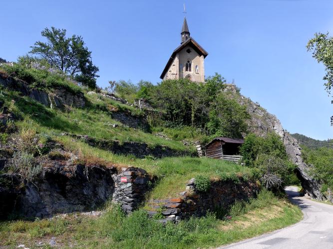
It's 11.1 km (6.9 mi) to the end of the tarmac at Le Villard, with 762 m (2500 ft) of climbing at 6.9%. The first 7.5 km are the work: a steady 7 to 8.5% in hairpins over Moûtiers, with the town and the valley dropping away under you, and the first houses of Hautecour at about 880 m roughly halfway. Above it the grade eases to 4 to 6% through Le Breuil, where a small lake, a chapel on a rock and a collection of outdoor sculptures make the obvious place to stop, and the last kilometer narrows to little more than a lane.
There's nothing at the top except a sign where the D85 ends and a lane carries on toward Montgirod. It's a short, honest climb, and it makes a good pairing with the Route de Montfort or Notre-Dame-du-Pré across the river for a morning of quiet Tarentaise hairpins.
PLAN YOUR ROUTE
 We've partnered with Sherpa-Map.com to bring you the best route planning tool. With a PRO Membership you can use this climb as a reference when creating your route.
The 11.1 km (6.9 mi) climb gains 762 m (2500 ft) at an average of 6.9%, from 498 m (1635 ft) in Moûtiers to 1260 m (4133 ft) at Le Villard.
The steepest kilometer averages 8.6% (around km 6.3 to 7.3), the steepest 2 km average 8.1% and the steepest 5 km average 7.8%.
Km 0 to 5: hairpins out of Moûtiers at 7 to 8.5%, to Hautecour at about 880 m.
Km 5 to 7.5: the hardest stretch, 7 to 8.5% with the steepest kilometer at 8.6%, to about 1070 m.
Km 7.5 to 11.1: easier, 4 to 6.5%, through Le Breuil (about 1110 m) to the end of the D85 at Le Villard.
Roadway: Paved to Le Villard, a narrow mountain road with only average pavement, patched in places. The last kilometer is narrower still. Past Le Villard the lane to Montgirod is signed closed to cars and motorbikes from 1 December to 30 April, and the whole slope gets snow in winter.
Traffic: Very light. The D85 serves Hautecour's hamlets and nothing beyond them, and riders report fewer than ten vehicles an hour. The only busy part is the first few hundred meters in Moûtiers, which is the transit hub for the Three Valleys resorts.
Parking: Moûtiers has public car parks around the town center and the station, which is a few hundred meters from the start, so it's easy to come by train. In Le Breuil, the car park by the plan d'eau de la Trappe (the Place des Arts, at about 1110 m) is a good place to meet if someone is driving up.
Gear: The first 7.5 km sit around 8% with very little relief, so a compact with a 30 or 32 at the back makes it a steady spin rather than a grind. The slope faces south and gets hot in summer, so start early and carry two bottles; outside July and August the 760 m drop back to Moûtiers can be chilly, so pack a gilet.
Provisions: Stock up in Moûtiers, which has bakeries, supermarkets and cafés. There's no shop on the climb. The Chalet de la Trappe, a restaurant by the lake at Le Breuil, is the only place to eat on the way up - check that it's open before counting on it.
Before heading out on any cycling adventure check out our Things to Bring on a Cycling Trip and use our interactive check list to ensure you don't forget anything.
Moûtiers is the base, with hotels, restaurants and the train station that serves the whole upper Tarentaise. It's also the start of the Val Thorens climb and a few kilometers from Route de Montfort and Notre-Dame-du-Pré, so you can stack several climbs into one day without moving the car.
Give Le Breuil ten minutes. The Lez'arts en Adret trail starts at the Place des Arts by the lake and loops 4.3 km past about 70 outdoor sculptures in stone, wood and straw, along with chapels, an old bread oven and the bachals, the hamlets' old water troughs. It's a walk, not a ride, but the first few hundred meters around the lake are flat. Lower down, Hautecour's Saint-Étienne church is a listed Baroque church on the Tarentaise Baroque route, with guided visits on request.
The other side of this slope, from Centron in the Isère valley, has its own page as Route d'Hautecour (Centron).
ROUTE MAP

MEMBER RATING
CURRENT WEATHER
PJAMM TRIPS ADVENTURE STARTER BUNDLES
Check out PJAMM Adventure's prepackaged (self-guided) cycling trips. They will help you plan, document and conquer your next adventure.
NEARBY CLIMBS (0) RADIAL PROXIMITY
FROM No Climbs Found
MEMBER REVIEWS & COMMENTS
Let us know what you thought of this climb. Signup for our FREE membership to write a review or post a comment.
Already have an account?
LOG IN HERE
