
28.2
PDI
11.3 mi
DISTANCE
4,319 ft
GAINED
7 %
AVG. GRADE
FULL CLIMB STATS
INTRO
PLAN YOUR ROUTE
 We've partnered with Sherpa-Map.com to bring you the best route planning tool. With a PRO Membership you can use this climb as a reference when creating your route.
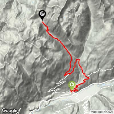
 Cormet d'Areches runs 18.2 km (11.3 mi) from Aime, gaining 1,316 m (4,319 ft) at an average grade of 7.0%.
The steepest riding comes in short bursts rather than one long wall: the steepest quarter-mile averages 11.8%, and the steepest full mile 10.0%. Over longer windows the climb settles down - the steepest 5 km averages 9.3% and the steepest 10 km eases to 7.1%, reflecting the more gradual grade of the valley approach out of Aime before the road tightens up higher on the mountain.
Roadway: Paved for most of the distance out of Aime, with the final several kilometers below the pass turning to a rougher, unpaved track - wide tires or a gravel/mountain bike are a real asset for that section, more so than on many Alpine gravel finishes. Like most high Beaufortain passes, Cormet d'Areches is seasonal - generally rideable from around mid-June through mid-October and closed by snow the rest of the year, so check current conditions before an early- or late-season attempt.
Traffic: Light. This is a quiet secondary route compared to its neighbor Cormet de Roselend, and traffic thins out further once the pavement ends.
Parking: Park in Aime, in the Tarentaise valley, where the climb begins; the town has ample free street parking and is also a stop on the Bourg-Saint-Maurice rail line.
Aime has grocery stores, bakeries, and restaurants for a full resupply before you start. The small hamlet of Granier, partway up, has little beyond a few homes - plan to carry what you need for the rest of the climb after leaving Aime.
Before heading out on any cycling adventure check out our Things to Bring on a Cycling Trip and use our interactive check list to ensure you don't forget anything.
Cormet d'Areches sits in the shadow of its far more famous neighbor, Cormet de Roselend - a Tour de France fixture with over a dozen appearances since 1979 - but the two passes ride very differently. Where Roselend draws a steady stream of cyclists and sightseers to its dam and turquoise lake, Areches stays genuinely quiet, helped along by its unpaved finish on both sides.
Aime, at the base, is a working Tarentaise valley town with its own train station on the line toward Bourg-Saint-Maurice, making this a workable climb to pair with a rail-based trip rather than requiring a car.
If you're touring the region, Roselend and the Beaufortain's other passes - Col du Pre, and the cheese-making town of Beaufort itself - are all within range on the north side of this same massif. See our Routes in the Area tool to plan a multi-pass trip.
ROUTE MAP
MEMBER RATING
CURRENT WEATHER
PJAMM TRIPS ADVENTURE STARTER BUNDLES
Check out PJAMM Adventure's prepackaged (self-guided) cycling trips. They will help you plan, document and conquer your next adventure.
NEARBY CLIMBS (0) RADIAL PROXIMITY
FROM No Climbs Found
MEMBER REVIEWS & COMMENTS
Let us know what you thought of this climb. Signup for our FREE membership to write a review or post a comment.
Already have an account?
LOG IN HERE
