
20.4
PDI
7.9 mi
DISTANCE
3,065 ft
GAINED
7.4 %
AVG. GRADE
FULL CLIMB STATS
INTRO
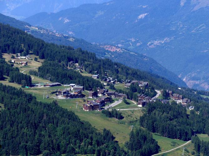
Les Coches climbs 12.7 km (7.9 mi) from the Tarentaise valley village of Landry, at 759 m (2,490 ft), up the forested mountainside through Montchavin to the ski village of Les Coches and on above it to 1,693 m (5,555 ft). It gains 934 m (3,065 ft) at a 7.4% average grade and ranks #954 on our list of the world's hardest climbs.
This is the Landry approach to the La Plagne massif, and it rides differently from the classic Tour de France route from Mâcot. It is a steadier forest road that sits close to 7% for most of the distance, then stiffens above Les Coches, where the kilometers climb at 8% to 10%.
The two villages on the way are young by Alpine standards. Montchavin opened in 1972 on the site of an abandoned hamlet, and Les Coches followed in 1977, designed by Michel Bezançon in a Savoyard, family-friendly style. Together they form part of Paradiski, the linked ski area that connects La Plagne with Les Arcs.
PLAN YOUR ROUTE
 We've partnered with Sherpa-Map.com to bring you the best route planning tool. With a PRO Membership you can use this climb as a reference when creating your route.
Les Coches climbs 12.7 km (7.9 mi) and 934 m (3,065 ft) at a 7.4% average, from 759 m (2,490 ft) in Landry to 1,693 m (5,555 ft) at the top. The steepest 0.5 km (0.3 mi) averages 11.5%, the steepest 1 km (0.6 mi) 10.7%, the steepest 2 km (1.2 mi) 9.8%, the steepest 5 km (3.1 mi) 8.3% and the steepest 10 km (6.2 mi) 7.5%.
For the first 9 km (5.6 mi) the road is remarkably even: nearly every kilometer lands between 6.2% and 7.3%, so it rewards a steady rhythm. Montchavin comes at roughly 7 km (4.3 mi), at about 1,250 m (4,100 ft), and Les Coches at about 9.7 km (6.0 mi), around 1,420 m (4,660 ft). The real work starts above the village, where the next kilometers average 7.6%, 8.4% and then 10.4% before the grade backs off to 7.9% over the closing stretch. Hold something back for those last 3 km (1.9 mi).
Roadway: The D225 climbs from Landry on a wide resort road through forest, with long ramps and hairpins up to Montchavin. The surface is good through the lower part of the climb, but it gets rougher with altitude, and above Les Coches the road narrows and the pavement is patchy, with damage still reported there in June 2026. Take it easy on the rough upper section, especially at the start of the descent, where potholes are common.
Traffic: Light for most of the year. This is a resort access road rather than a through route, so you mostly share it with residents, delivery vehicles and cars heading to the villages. It is busiest during the winter ski season and the peak summer weeks, and quietest in spring and autumn.
Parking: Landry is a small village on the Tarentaise rail line with its own TER station, which makes it an easy start without a car using the trains from Bourg-Saint-Maurice and Aime. If you drive, park considerately in the village rather than on the access road itself.
Gear: A standard road bike works, but a compact crankset helps on the 8% to 10% kilometers above Les Coches. Carry a spare tube and ride cautiously on the rougher upper road and on the descent.
Provisions: There are no services on the lower climb, so carry what you need from Landry. The resort villages above run on a reduced schedule outside the ski season and the summer holidays, so do not count on shops being open.
Before heading out on any cycling adventure check out our Things to Bring on a Cycling Trip and use our interactive check list to ensure you don't forget anything.
Landry is worth a few minutes before you roll out. Its Saint-Michel church, consecrated in 1687, is a stop on the Baroque in Haute-Tarentaise trail, and the GR 5 hiking path passes through the village. Landry shares the Peisey-Vallandry ski area with neighboring Peisey-Nancroix, and the Vanoise Express cable car, which opened in 2003 to connect La Plagne with Les Arcs, has its station at Montchavin-Les Coches, so you are riding past the link that makes up Paradiski.
The Tarentaise has more climbing than you can fit into one trip. Our La Plagne page covers the Tour de France approach from Mâcot, Col de Plan Bois West climbs a quiet lane from Sangot, and Arc 2000 and Cormet d'Areches both start nearby on the other side of the valley. Our Routes in the Area tool is a good way to see how they fit together and plan a custom route from Landry.
ROUTE MAP

MEMBER RATING
CURRENT WEATHER
PJAMM TRIPS ADVENTURE STARTER BUNDLES
Check out PJAMM Adventure's prepackaged (self-guided) cycling trips. They will help you plan, document and conquer your next adventure.
NEARBY CLIMBS (0) RADIAL PROXIMITY
FROM No Climbs Found
MEMBER REVIEWS & COMMENTS
Let us know what you thought of this climb. Signup for our FREE membership to write a review or post a comment.
Already have an account?
LOG IN HERE
