

23.1
PDI
6.1 mi
DISTANCE
2,957 ft
GAINED
9.1 %
AVG. GRADE
FULL CLIMB STATS
INTRO
Col de Plan Bois West climbs 9.9 km (6.1 mi) from the hamlet of Sangot, in Macot-la-Plagne, up to Le Chanton in neighboring Bellentre - a quiet back road on the lower slopes of the La Plagne ski massif, deep in Savoie's Tarentaise valley in the French Alps. It gains 902 m (2,957 ft) at a 9.1% average grade, with the road's steepest quarter-mile pitching up to 14.9%.
Unlike La Plagne's better-known access roads, which carry ski traffic and tour buses in season, the Route de Plan Bois is a narrow, sparsely-traveled lane that most cyclists passing through the valley overlook entirely. It climbs steadily through forest and scattered Tarentaise hamlets rather than switchbacking up an open resort face, so the reward here is solitude and a quieter side of the mountain more than a dramatic hairpin-stacked profile.
The road tops out at 1,705 m (5,593 ft) on the fringe of the La Plagne domain, within reach of the resort's mid-mountain trail network for anyone wanting to extend the ride further into the massif on foot or by bike. As with most Tarentaise back roads at this elevation, expect the upper stretch to be snow-affected outside the late-spring-through-autumn riding season.
PLAN YOUR ROUTE
 We've partnered with Sherpa-Map.com to bring you the best route planning tool. With a PRO Membership you can use this climb as a reference when creating your route.
 From Sangot, Col de Plan Bois West gains 902 m (2,957 ft) over 9.9 km (6.1 mi) at a 9.1% average grade - a steady, sustained pitch with no significant flat or descending sections to recover on. The steepest quarter-mile comes early, at 14.9%, and the first half-mile still averages 12.5%.
The climb settles into a more even rhythm after that: the first mile averages 11.8%, the first 4 km (2.5 mi) average 10.6%, and the full climb-long average of 9.1% reflects a consistently hard grade from bottom to top rather than a few brutal ramps mixed with easy recovery. Our world-difficulty ranking places this climb at #701 among the climbs in our database - a legitimately tough number for its length.
Roadway: The Route de Plan Bois is a narrow, paved secondary road the entire way, confirmed by recent street-level imagery of the route. It's a quiet local lane rather than a numbered highway, so don't expect wide shoulders or much passing room - ride single file and stay alert through blind corners on the forested lower half.
Traffic: Light. This road serves the small hamlets it passes through rather than any resort or through-traffic route, so most days you'll share it with only local residents and the occasional farm vehicle.
Parking: There's no dedicated cyclist parking at either end. Riders based in Macot-la-Plagne or Aime-la-Plagne, down in the valley, can park in either town and ride up from there, or look for a pull-off near the start in Sangot.
Gear: A compact crankset or a wide-range cassette is worth having - there's no flat or downhill stretch on this climb to spin out on, and the opening quarter-mile at 14.9% arrives before you've had much chance to warm up.
Provisions: There's nothing along the route itself. Stock up in Aime-la-Plagne or Macot-la-Plagne, down in the valley, before starting - neither Sangot nor Le Chanton has services for passing cyclists.
Before heading out on any cycling adventure check out our Things to Bring on a Cycling Trip and use our interactive check list to ensure you don't forget anything.
Macot-la-Plagne and Aime-la-Plagne, in the valley below, make a practical base - both sit on the Bourg-Saint-Maurice to Albertville rail line, with regular regional trains that make this an easy climb to reach without a car. The Route de Plan Bois itself has almost none of the trailside amenities you'd find on a bigger resort road, so this is very much a ride for solitude rather than convenience.
For anyone based here looking to build out a bigger day, the Tarentaise valley is stacked with other climbs within a short drive - see our Routes in the Area tool for other nearby options to combine with this one.
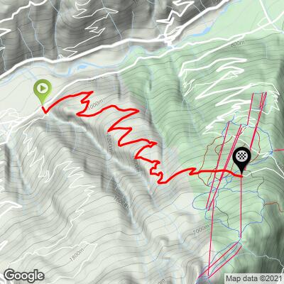
ROUTE MAP
MEMBER RATING
CURRENT WEATHER
PJAMM TRIPS ADVENTURE STARTER BUNDLES
Check out PJAMM Adventure's prepackaged (self-guided) cycling trips. They will help you plan, document and conquer your next adventure.
NEARBY CLIMBS (0) RADIAL PROXIMITY
FROM No Climbs Found
MEMBER REVIEWS & COMMENTS
Let us know what you thought of this climb. Signup for our FREE membership to write a review or post a comment.
Already have an account?
LOG IN HERE
