
20.2
PDI
8.9 mi
DISTANCE
3,230 ft
GAINED
6.9 %
AVG. GRADE
FULL CLIMB STATS
INTRO
PLAN YOUR ROUTE
 We've partnered with Sherpa-Map.com to bring you the best route planning tool. With a PRO Membership you can use this climb as a reference when creating your route.
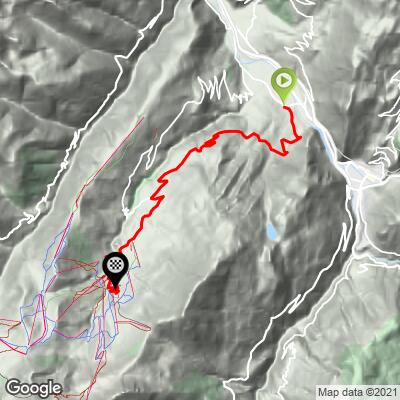
The average grade is 6.9% over 14.3 km (8.9 mi), rising from 469 m (1,538 ft) to 1,449 m (4,754 ft). The steepest 0.5 km (0.3 mi) averages 9.2%, the steepest 2 km (1.2 mi) 7.8%, the steepest 5 km (3.1 mi) 7.5% and the steepest 10 km (6.2 mi) 7.2%. The hardest single pitch, about 100 yards (91 m), reaches 10.4%.
Because even the toughest stretches stay close to the average, riders describe a steady 7% to 8% for much of the way. Pace it like a time trial rather than a series of efforts, and a compact chainring will keep it comfortable.
Roadway: The Route de Valmorel is paved the whole way and wide, with a very good surface that riders consistently praise. It is a resort access road, so the final kilometers are a series of short hairpins into the village. The descent is easy and pleasant. Expect snow and ice on the upper road in the colder months.
Traffic: Light outside ski season. In busy periods the free resort shuttle buses use the climb, so keep an ear out on the hairpins. The valley road below is much busier than the climb itself.
Parking: The start is on the valley floor in Grand-Aigueblanche, within about 1 km (0.6 mi) of the center of Aigueblanche, where the public car parks are covered in detail on our La Quermoz Sud page (the free Parking du Château is the easiest all-day option).
Provisions: Valmorel is a resort built around winter, so the summer offering at the top is quieter and more limited than in ski season. Carry your own water and food for the full 14.3 km (8.9 mi); shade is limited and there is little reason to expect to top up between the valley and the station.
Gear: A compact chainring (34 teeth or smaller) with a wide-range cassette suits the steady 7% to 8% grade. Bring a windproof layer for the descent, which is long and cools quickly in the shade.
Before heading out on any cycling adventure check out our Things to Bring on a Cycling Trip and use our interactive check list to ensure you don't forget anything.
Les Avanchers is the one stop worth making on the way up. Its church of Saint-André, built in 1676 and redecorated in Neogothic style in 1845, still holds a baroque main altarpiece made in 1684, and a stone cross dated 1676 stands opposite the gate. The commune was folded into Aigueblanche in 1972 and separated again in 1987, when the Valmorel resort was created.
The resort itself opened in 1976 and is a deliberate blend of wood and stone chalets. In summer the tourist office holds the national Accueil Vélo label for cyclist services, and the valley has run free bike-wash stations in Valmorel and at Doucy station. The resort's bike park reaches 365 km (227 mi) of mountain bike trails across 27 routes, lift-served from late June, if you want a rest day on knobby tires.
La Léchère-les-Bains is the usual base for road riders here, with Valmorel, Nâves, Doucy and the Col de la Madeleine all within reach - see our Col de la Madeleine North page for the big neighbor. To see the other climbs on this side of the Isère valley, including the Doucy road and the La Quermoz routes, try our Routes in the Area tool.
ROUTE MAP
MEMBER RATING
CURRENT WEATHER
PJAMM TRIPS ADVENTURE STARTER BUNDLES
Check out PJAMM Adventure's prepackaged (self-guided) cycling trips. They will help you plan, document and conquer your next adventure.
NEARBY CLIMBS (0) RADIAL PROXIMITY
FROM No Climbs Found
MEMBER REVIEWS & COMMENTS
Let us know what you thought of this climb. Signup for our FREE membership to write a review or post a comment.
Already have an account?
LOG IN HERE
