
18.5
PDI
12.9 mi
DISTANCE
3,669 ft
GAINED
4.8 %
AVG. GRADE
FULL CLIMB STATS
INTRO
PLAN YOUR ROUTE
 We've partnered with Sherpa-Map.com to bring you the best route planning tool. With a PRO Membership you can use this climb as a reference when creating your route.
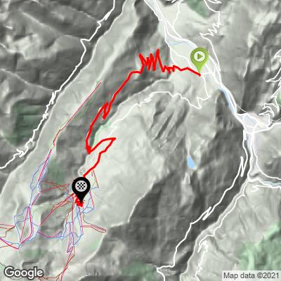
Valmorel (Route de Doucy) is 20.7 km (12.9 mi) long and climbs 1,118 m (3,669 ft) at an average of 4.8%, from 469 m (1,538 ft) to 1,449 m (4,754 ft). It also includes about 138 m (453 ft) of descent, so the climbing sections are steeper than the average suggests.
The first kilometer is nearly flat at about 2%. From there the Route de Doucy settles into a long, regular climb of 6% to 7.7% for 7 km (4.3 mi), reaching about 970 m (3,182 ft) below Doucy. Past Raclaz the road dips briefly, climbs again to about 1,127 m (3,698 ft) at Le Villaret around km 12, then descends roughly 85 m (279 ft) on the Route du Morel through Le Meiller to the floor of the Morel valley.
After rejoining the Route de Valmorel near Les Avanchers at about km 15, the final 6 km (3.7 mi) climb at 5% to 7.5% through Le Pré and Le Crey to the resort.
Steepest sections: 100 yards (91 m) at 11.4%, 0.5 km (0.3 mi) at 8.7%, 1 km (0.6 mi) at 7.9%, 2 km (1.2 mi) at 7.6% and 5 km (3.1 mi) at 7.1%.
Roadway: Paved the whole way. The Route de Doucy and the hamlet roads through Raclaz, Le Villaret and Le Meiller are narrower, more rural lanes than the wide Route de Valmorel, with tighter bends and farm access along the way, so take the descent through the Morel valley with care. The last 6 km (3.7 mi) from Les Avanchers are on the main resort road, which riders consistently describe as wide and well surfaced. Snow and ice are likely on the upper roads from late autumn into spring.
Traffic: Light on the Doucy side, where the roads mainly serve the hamlets and the Doucy ski area. Traffic picks up once you join the Route de Valmorel at Les Avanchers, where resort traffic and, in busy periods, the free shuttle buses serving Valmorel share the final hairpins.
Parking: This climb starts at the same spot as our main Valmorel climb, on the valley floor in Grand-Aigueblanche. The free all-day car parks in the center of Aigueblanche are covered in detail on our La Quermoz Sud page. If you plan to loop back down the main Valmorel road, the Aigueblanche car parks put you right at the finish of the descent.
Provisions: Fill bottles and buy food in Aigueblanche before you start. The Doucy side is mostly small hamlets with no reliable shops in summer, and Valmorel, at the top, is a winter-first resort with a quieter summer offering. Carry enough for 20.7 km (12.9 mi) of mostly exposed road.
Gear: A compact crankset with a wide-range cassette suits the long 6% to 7.7% stretches. Bring a windproof layer for the descent, and make sure your brakes are in good shape for the narrow drop through the Morel valley.
Before heading out on any cycling adventure check out our Things to Bring on a Cycling Trip and use our interactive check list to ensure you don't forget anything.
This is the climb to ride if you want to see the old villages on the Doucy side of the Morel valley. In Raclaz, right on the route, the Musée d'Antan occupies the former village school and recreates a 1945 classroom, kitchen, bedroom and the schoolmaster's apartment. It opened in 1996, is free, and is usually open on Wednesday afternoons in July and August.
Doucy's own church holds a main altarpiece carved in 1698 and a rosary altarpiece from 1708, though it is generally closed to the public. Above the village, Doucy Station, the small ski area at Doucy-Combelouvière, has a viewpoint over the glaciers of the Vanoise, the Beaufortain and the upper Tarentaise, and one of the valley's free bike-wash stations. For the church at Les Avanchers and the Valmorel resort itself, see our Valmorel page. Conditions at Valmorel can be very different from the Isère valley floor, so check them with our Weather tool before you go.
ROUTE MAP
MEMBER RATING
CURRENT WEATHER
PJAMM TRIPS ADVENTURE STARTER BUNDLES
Check out PJAMM Adventure's prepackaged (self-guided) cycling trips. They will help you plan, document and conquer your next adventure.
NEARBY CLIMBS (0) RADIAL PROXIMITY
FROM No Climbs Found
MEMBER REVIEWS & COMMENTS
Let us know what you thought of this climb. Signup for our FREE membership to write a review or post a comment.
Already have an account?
LOG IN HERE
