
15.8
PDI
7.8 mi
DISTANCE
2,655 ft
GAINED
6.5 %
AVG. GRADE
FULL CLIMB STATS
INTRO
Almost everyone who rolls out of Aigueblanche with climbing in mind is heading for Valmorel. Cross to the north side of the Morel valley instead and you get the Route de Doucy: a wide, steady road up the open flank opposite the resort, with old farmhouses at the bottom, hay meadows higher up, and the valley floor dropping away behind you the whole time.
It's 12.5 km (7.8 mi) from the Isère to the Doucy ski station, with 809 m (2655 ft) of climbing at 6.5%. Once you're out of town the gradient barely moves - every kilometer from the second to the eleventh sits between 6.3% and 7.7%, and the hardest full kilometer is 8.2%. There's no wall and nowhere to coast, so find a gear early and leave it there.
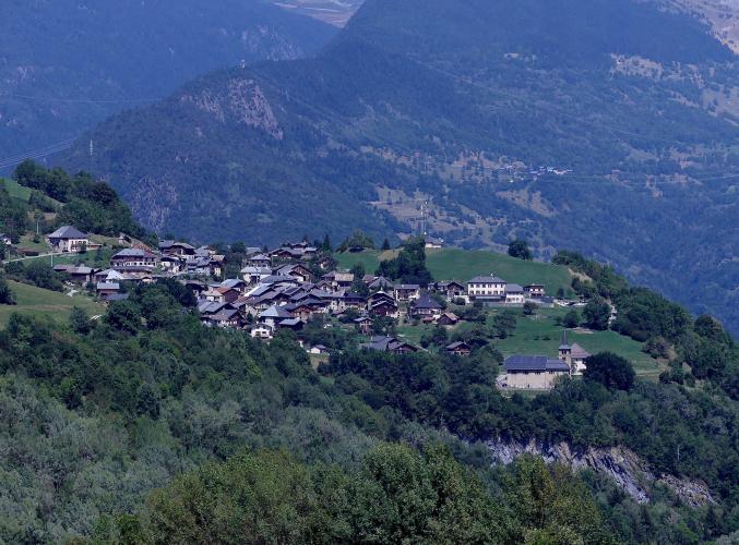
Around the 8 km mark you ride straight through Doucy itself, a tight cluster of stone houses and a baroque church, where the road squeezes between the walls for a few hundred meters. Above the village the Route de la Station swings back and forth across open pasture, the views widen over the Tarentaise, and the last half kilometer eases off into Combelouvière, the small resort that forms the Doucy end of the Valmorel ski area.
Look down into the Morel ravine as you climb. In the late 1800s the slope below Doucy was sliding into the torrent, and the state's mountain-restoration engineers spent decades building big stone dams in the gorge to hold it.
PLAN YOUR ROUTE
 We've partnered with Sherpa-Map.com to bring you the best route planning tool. With a PRO Membership you can use this climb as a reference when creating your route.
The Route de Doucy climbs 12.5 km (7.8 mi) from 468 m to 1277 m (1535 to 4191 ft), gaining 809 m (2655 ft) at an average of 6.5%.
The first kilometer, leaving Grand-Aigueblanche on the Route de Saint-Oyen, is an easy 2.5%. From there it settles into its rhythm: 6.5%, 7.3%, 7.7%, 6.6%, 6.3%, 7.6% and 6.3% for kilometers 2 to 8, then 7.6% through and above Doucy, 7.3%, 6.8% and 6.1% up the Route de la Station. The final half kilometer into Combelouvière drops to about 5%.
The steepest 1 km averages 8.2%, the steepest 0.5 km 9.4%, and the toughest 5 km 7.1%. Short ramps touch 10%, but none of them last. This is a pacing climb - start the second kilometer too hard and the next nine will let you know.
Roadway: Tarmac from the valley floor to the station. The Route de Saint-Oyen and Route de Doucy are a decent two-lane road with a center line, patched and cracked in places on the lower half but sound. Through the old village of Doucy the road narrows between houses and walls for a short stretch, so take it slowly on the way down. Above the village the Route de la Station is wider and smoother, built as the access road to the ski area. Expect snow and ice on the upper road from late autumn into spring.
Traffic: Light most of the year - you'll meet residents, farm vehicles and the odd delivery van. It picks up during the ski season and the summer holidays, when the Route de la Station is the main way up to the station's chalets and holiday residences, but it rarely feels busy.
Parking: Park in the center of Aigueblanche, about 1 km from the start - the free Parking du Château and Parking de la Liberté are the easy all-day choices (details on our La Quermoz Sud page). If someone is driving up to meet you, the station has an open-air car park at the top.
Gear: Nothing exotic. A compact with a 30 or 32 at the back handles the steady 6 to 8% comfortably, and there's no ramp long enough to need anything lower. Pack a windproof for the descent - it's 12 km of fast, open road back to the valley.
Provisions: Fill bottles and buy food in Aigueblanche; there's nothing to buy on the way up through Saint-Oyen or Doucy. The station has a couple of small shopping arcades, La Placette and La Biollène, but don't count on them being open outside the busiest weeks of summer.
Before heading out on any cycling adventure check out our Things to Bring on a Cycling Trip and use our interactive check list to ensure you don't forget anything.
Stop at the top for a few minutes. Doucy station has an orientation table looking out over the Tarentaise and the glaciers of the Vanoise, a free bike-wash station, and, from late June, the Combelouvière chairlift running for mountain bikes into the Valmorel trail network if you fancy swapping bikes for an afternoon.
For a longer day, ride over to Valmorel rather than straight back down: our Valmorel (Route de Doucy) page follows the hamlet lanes from Doucy across the Morel valley to Les Avanchers and the resort, and has the story of Doucy's church altarpieces and the little Musée d'Antan in Raclaz. Down the main Valmorel road and you're back in Aigueblanche for a neat loop.
La Léchère-les-Bains, a few kilometers down the Isère, is the usual base, with a spa if your legs want one and the Col de la Madeleine starting right from town. Grand-Aigueblanche's Chalet de l'Epigny holds the Accueil Vélo label for cyclist-friendly lodging.
ROUTE MAP

MEMBER RATING
CURRENT WEATHER
PJAMM TRIPS ADVENTURE STARTER BUNDLES
Check out PJAMM Adventure's prepackaged (self-guided) cycling trips. They will help you plan, document and conquer your next adventure.
NEARBY CLIMBS (0) RADIAL PROXIMITY
FROM No Climbs Found
MEMBER REVIEWS & COMMENTS
Let us know what you thought of this climb. Signup for our FREE membership to write a review or post a comment.
Already have an account?
LOG IN HERE
