

22
PDI
9.9 mi
DISTANCE
3,549 ft
GAINED
6.8 %
AVG. GRADE
FULL CLIMB STATS
Page Contributor(s): Lisa Irizarry and Matt Jiang, NY, NY
INTRO
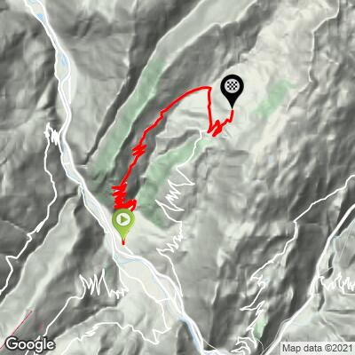
La Quermoz Nord climbs 15.9 km (9.9 mi) from the floor of the Isère valley at Grand-Cœur, up the D93 through Petit-Cœur, Molençon and Fontaines, to the Nâves plateau at about 1,560 m (5,117 ft). It gains 1,082 m (3,549 ft) at a 6.8% average. It is the northern of our two routes to the high ground beneath Le Quermoz, and it finishes at the same spot on the plateau as La Quermoz Sud, which starts from Aigueblanche.
This is the tougher, more front-loaded of the pair. The road leaves the valley floor in a run of tight switchbacks - about 16 of them in the opening kilometers, mostly at 9% to 10% and steeper in places - and the hardest 10 km (6.2 mi) averages 7.4%, more than half a point above the overall figure. The slope faces south, so there is little shade, and the payoff is early: views open up across the Tarentaise valley toward the Lauzière and Vanoise peaks. After Fontaines the grade eases, and the last kilometer or so mellows to about 3.5% as you roll onto the plateau.
Traffic is minimal, which makes this a rewarding quiet alternative to the big passes nearby. Riders tend to remember the switchbacks, the views and the calm: a short, hard workout with real Alpine scenery, finishing at the Nordic ski center at Grand Nâves.
PLAN YOUR ROUTE
 We've partnered with Sherpa-Map.com to bring you the best route planning tool. With a PRO Membership you can use this climb as a reference when creating your route.
 The average grade is 6.8% over 15.9 km (9.9 mi), climbing from about 487 m (1,599 ft) at Grand-Cœur to about 1,560 m (5,117 ft) on the Nâves plateau, a gain of 1,082 m (3,549 ft).
The steepest 90 m (100 yards) averages 10.6%, the steepest 0.4 km (0.25 mi) 9.6% and the steepest 0.5 km (0.3 mi) 9.8%. The steepest kilometer (0.6 mi) averages 9.1%, the steepest 2 km (1.2 mi) 8.8%, the steepest 5 km (3.1 mi) 7.8% and the steepest 10 km (6.2 mi) 7.4%.
The pattern matters more than any one number. The hardest 10 km of the climb is packed into the lower part of the route, and the remaining kilometers average under 6%, so the climb is front-loaded. Start conservatively in the switchbacks, keep the effort steady through Molençon, and use the easier grade after Fontaines to recover before the finish.
Roadway: The route follows the D93 and is paved throughout, but the surface varies: recent rider reports describe it as good at the start, average in the middle and poor on the final stretch through Nâves toward Grand Nâves, with some sections resurfaced and others uneven. The descent back down the D92 through Châtelard and Navette, which is the road our La Quermoz Sud route takes, is also reported to have poor pavement, so take it easy on the way down.
Traffic: Very little. Riders report meeting only a few vehicles on the way up.
Parking: The recorded start is at the foot of the mountain near Grand-Cœur, on the valley floor. A common alternative is to start at the church and town hall in Petit-Cœur, which trims the climb slightly to about 15.4 km (9.6 mi) and 1,038 m (3,405 ft). At the top, the Nordic center car park at Grand Nâves, on the Route du Fruit Commun, is where the climb ends.
The road faces south and has little shade, so in summer start early and carry enough water for the switchbacks. The plateau is more than 1,000 m (3,300 ft) above the start and noticeably cooler, so pack a windproof layer for the descent.
There are fountains and a small restaurant at Grand Nâves, which makes it easy to top up bottles or eat before turning around. Gearing with a 32-tooth cassette is a good idea for the opening switchbacks, and 28 mm tires are more comfortable on the rougher upper road.
Before heading out on any cycling adventure check out our Things to Bring on a Cycling Trip and use our interactive check list to ensure you don't forget anything.
The Nâves plateau is a small, sunny, low-key mountain village with Nordic France status, and the Maison de la Montagne at 77 route du Fruit Commun in Grand Nâves is the hub: it offers equipment rental including electric mountain bikes, and it runs the Nordic ski domain in winter. That domain has about 42 km (26 mi) of pistes, including the highest cross-country track in Savoie at 1,984 m (6,509 ft).
In summer the same high ground has ten marked mountain-bike routes plus an enduro track, and about thirty climbing routes graded 4c to 6b+ on the Roche des Foyères. Strong hikers can reach the Nant du Beurre eco-refuge at 2,080 m (6,824 ft), which sleeps up to 38. For the hike up Le Quermoz itself, the paragliding launch at Lac du Bozon and the village festivals, see our La Quermoz Sud page, which covers them in detail.
ROUTE MAP
MEMBER RATING
CURRENT WEATHER
PJAMM TRIPS ADVENTURE STARTER BUNDLES
Check out PJAMM Adventure's prepackaged (self-guided) cycling trips. They will help you plan, document and conquer your next adventure.
NEARBY CLIMBS (0) RADIAL PROXIMITY
FROM No Climbs Found
MEMBER REVIEWS & COMMENTS
Let us know what you thought of this climb. Signup for our FREE membership to write a review or post a comment.
Already have an account?
LOG IN HERE
