

22.2
PDI
10 mi
DISTANCE
3,566 ft
GAINED
6.8 %
AVG. GRADE
FULL CLIMB STATS
Page Contributor(s): Lisa Irizarry and Matt Jiang, NY, NY
INTRO
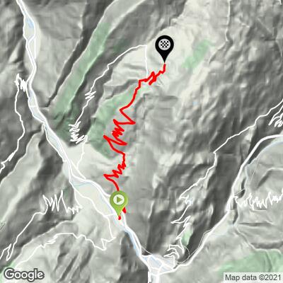
La Quermoz Sud climbs 16.0 km (10.0 mi) from the center of Aigueblanche, in the Isère valley of Savoie, to the Nâves plateau at 1,558 m (5,112 ft), gaining 1,087 m (3,566 ft) at a 6.8% average. It takes its name from Le Quermoz, the 2,297 m summit that rises above the plateau, and it is the southern of our two routes up to that high ground (see also La Quermoz Nord).
This is a rhythm climb rather than a wall. The D92 leaves town and works up through the hamlets of Villarberenger, Villoudry and Navette before continuing past Vorchère to Grand Nâves, and about 91.9% of the distance sits between 5% and 10%. Hairpins along the way open views across the valley toward Valmorel and the Lauzière range, and the traffic is light.
At the top you are on the Nâves plateau, Nordic ski terrain in the Beaufortain massif with Le Quermoz overhead. To see the other climbs on this side of the Isère valley, including La Quermoz Nord and the Valmorel routes, try our Routes in the Area tool.
PLAN YOUR ROUTE
 We've partnered with Sherpa-Map.com to bring you the best route planning tool. With a PRO Membership you can use this climb as a reference when creating your route.
 The average grade is 6.8% over 16.0 km (10.0 mi), and it is remarkably even: about 91.9% of the route is between 5% and 10%, about 7.1% is under 5%, and only about 1.0% (0.2 km, 0.1 mi) is between 10% and 15%.
The steepest quarter-mile (0.4 km) averages 9.1%, the steepest mile (1.6 km) 8.0%, and the steepest kilometer (0.6 mi) 8.2%. Even the hardest 5 km (3.1 mi) averages 7.5%, so there are few places to recover once you are moving. Settle into a steady effort early and save something for kilometers 14 and 15 (miles 8.7 to 9.3), where the road tilts up to 8.1% before easing near the finish.
Roadway: The road is paved throughout, but this is a rural mountain road rather than a showpiece col: expect a narrow carriageway with no shoulder, and rougher, patched pavement with some loose gravel in places on the upper forested sections, so take care on the descent. The plateau is Nordic ski terrain in winter, so expect snow on the upper road from late autumn into spring.
Traffic: Very light once you are a few kilometers out of Aigueblanche. Most vehicles are local, plus visitors heading to the Nâves Nordic area in winter and to the Le Quermoz trailheads in summer.
Parking: Aigueblanche has several public car parks along the Grande Rue and around the town center. The free 50-space Parking du Château (Place du Château) and the free 35-space Parking de la Liberté (by La Poste) are the easiest all-day options; the car parks directly on the Grande Rue are blue zones limited to 1 hour 30 minutes, so avoid those.
The finish is more than 1,000 m (3,300 ft) above the start, so the temperature at the plateau can be noticeably cooler than in the valley. Bring a windproof layer for the descent, which is long and includes many hairpins.
There is little on the route, so fill bottles and carry food in Aigueblanche. A restaurant is listed near the finish, but hours vary. Since the upper road can be patchy, tires with a little volume (28 mm or wider) make for a more comfortable day.
Before heading out on any cycling adventure check out our Things to Bring on a Cycling Trip and use our interactive check list to ensure you don't forget anything.
Aigueblanche sits in the Jardins de la Tarentaise and has more character than a first glance suggests. In the neighboring hamlet of Villargerel, the Baroque church of Saint-Martin (rebuilt in the 1680s) is known for its painted interior and altarpieces, and guided visits are run on set days in season - ask at the La Léchère-les-Bains tourist office.
The Nâves plateau is worth a stop if you have time. In summer it offers hiking, mountain biking, climbing and paragliding from Lac du Bozon; from the parking at Grand Nâves a hike to the summit of Le Quermoz gains roughly 1,000 m and rewards you with a 360 degree panorama over the Tarentaise, the Vanoise and Mont Blanc. The Beaufort Festival in August and the Cortis d'en haut celebration in September bring the village to life. Valmorel and the Doucy road start from the same valley and have their own pages.
ROUTE MAP
MEMBER RATING
CURRENT WEATHER
PJAMM TRIPS ADVENTURE STARTER BUNDLES
Check out PJAMM Adventure's prepackaged (self-guided) cycling trips. They will help you plan, document and conquer your next adventure.
NEARBY CLIMBS (0) RADIAL PROXIMITY
FROM No Climbs Found
MEMBER REVIEWS & COMMENTS
Let us know what you thought of this climb. Signup for our FREE membership to write a review or post a comment.
Already have an account?
LOG IN HERE
