
22.3
PDI
6.3 mi
DISTANCE
2,936 ft
GAINED
8.8 %
AVG. GRADE
FULL CLIMB STATS
INTRO
PLAN YOUR ROUTE
 We've partnered with Sherpa-Map.com to bring you the best route planning tool. With a PRO Membership you can use this climb as a reference when creating your route.
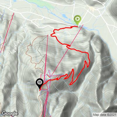
 Samoëns 1600 climbs 895 m (2,936 ft) over 10.1 km (6.3 mi), from 737 m (2,418 ft) in Samoëns to 1,620 m (5,316 ft) at the station, at an average grade of 8.8%.
The steepest 100 yards (91 m) reach 19.6%, the steepest quarter mile (0.4 km) averages 14.6%, and the steepest half mile (0.8 km) 13.5%. The steepest kilometer (0.6 mi) holds 13.1%, the steepest 2 km (1.2 mi) 12.4%, and the steepest 5 km (3.1 mi) 10.8%.
The climb begins gently through Vercland, so the steep part comes as a surprise: after the right-hand turn there are roughly 3 km (1.9 mi) of relentless double-digit grade before the road eases a little for the final stretch. Save something for that turn.
Roadway: The road is paved all the way to the station and generally reported in good condition, with some rough patches in places. It is open year-round, though winter access depends on snow, and the upper road can hold snow and ice outside summer.
Traffic: Quiet for most of the year - the road serves the ski station rather than a through route, so you meet mostly resort-bound cars and other cyclists, with more traffic in the winter ski season.
Parking: At the top, the Parking des Saix at Samoëns 1600 is free, open year-round and holds 517 cars, useful if someone is meeting you. In Samoëns itself, the free lots by the tourist office described on our Col de Joux Plane (Samoëns) page also serve this start.
Provisions: There is nothing on the road between Vercland and the station, so stock up in Samoëns and carry enough water for the whole 10.1 km (6.3 mi). The station has a restaurant in the summer season, though hours vary.
Gear: Gear low. With about 3 km (1.9 mi) at 11 to 12% in the middle, a compact crankset with a 30 to 32 tooth cog is the sensible choice. The station at 1,620 m (5,316 ft) is noticeably cooler than Samoëns, so pack a wind layer for the top and the descent.
Before heading out on any cycling adventure check out our Things to Bring on a Cycling Trip and use our interactive check list to ensure you don't forget anything.
Samoëns village has its own charms - the covered Grenette market, the Gros Tilleul and the Jaÿsinia alpine garden - and they are covered on our Col de Joux Plane (Samoëns) page, so this page focuses on what waits at the top.
In summer the Grand Massif Express gondola runs up to the Samoëns 1600 station, and the plateau is a hub for hikes toward the Tête des Saix and the Lac des Gouilles Rouges, where you can also fish. The paragliding launch sits at about 1,632 m (5,354 ft), and a restaurant on the plateau serves through the summer season, so it makes a good place to refuel with Mont Blanc views before descending.
Check current conditions at the base and the top before you set off with our Weather tool.
ROUTE MAP
MEMBER RATING
CURRENT WEATHER
PJAMM TRIPS ADVENTURE STARTER BUNDLES
Check out PJAMM Adventure's prepackaged (self-guided) cycling trips. They will help you plan, document and conquer your next adventure.
NEARBY CLIMBS (0) RADIAL PROXIMITY
FROM No Climbs Found
MEMBER REVIEWS & COMMENTS
Let us know what you thought of this climb. Signup for our FREE membership to write a review or post a comment.
Already have an account?
LOG IN HERE
thall1
A great climb. Very steep in the first part but chills out the slightest bit after that.
Enjoyment: 77/100
