
19.2
PDI
9.4 mi
DISTANCE
3,194 ft
GAINED
6.4 %
AVG. GRADE
FULL CLIMB STATS
INTRO
PLAN YOUR ROUTE
 We've partnered with Sherpa-Map.com to bring you the best route planning tool. With a PRO Membership you can use this climb as a reference when creating your route.
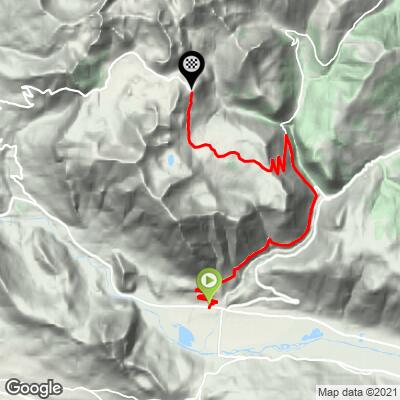
Col de la Ramaz Sud averages 6.4% over 15.1 km (9.4 mi), but almost all of the real climbing is packed into the middle. The first 4 km (2.5 mi) out of Taninges run at about 5.5-6%, with a steeper kick to about 8.7% in km 4, then km 5 to km 7 drop to 3-5% - a chance to spin before the hard part.
From about km 7 to km 11 the road holds 9-11% through forest past La Savolière. This is where you'll find the steepest 500 m (12.4%), the steepest kilometer (11.3%) and the steepest 2 km (10.1%), and the steepest 5 km average 9.2%. The grade then falls to around 3-4% across the Praz de Lys plateau before a final kilometer at about 8.7% to the finish.
Roadway: Paved the entire way. The lower D307 through Rond is a narrow, twisty country road with a surface that's only average in places; the Praz de Lys road above Fry is wider, and conditions were rated good in 2024. Rockfall has shut this road before - a slide cut the D328 between its junctions with the D307 and the D308 in August 2019 - so check Haute-Savoie's road information before riding in spring or after storms. Diversions can also bring extra traffic: in June 2026 the department closed the parallel D902 between the Pont des Gets and Avonnex for two days and sent cars over the Col de la Ramaz instead.
Traffic: Light. Taking the D307 through Rond keeps you off the busier D902 Les Gets road, which is what makes this the quiet way out of Taninges. The Praz de Lys road above Fry carries resort traffic, but even in summer it's mostly local cars and other cyclists.
Parking: Taninges is a small market town at the foot of the Giffre valley, and the climb starts in the town itself, so park in the center and ride straight out. If you'd rather skip the lower valley, you can drive up to the Praz de Lys resort and park on the plateau above the steep section.
Gear: A compact crankset with a 30-32 tooth low cog makes the 4.5 km (2.8 mi) of 9-11% above Fry far more manageable. There's no let-up once that section starts, so pace the easy first half. Pack a light jacket for the descent.
Provisions: Fill your bottles in Taninges. There's little on the road itself, services up on the Praz de Lys plateau are seasonal and limited, and there's nowhere to eat or drink at the finish.
Before heading out on any cycling adventure check out our Things to Bring on a Cycling Trip and use our interactive check list to ensure you don't forget anything.
Taninges is the base for this side, and its big sight is the Chartreuse de Mélan, a Carthusian monastery founded in 1285 by Béatrice de Faucigny and owned by the Haute-Savoie department since 1906. Entry is free, and alongside the church, with its contemporary stained glass, there's a 3-hectare outdoor contemporary sculpture park; it's open roughly from April to the start of November. For an easy rest day, the Au fil du Giffre greenway leaves Taninges on a 26.5 km (16.5 mi) route away from cars, open to bikes.
Up top, the Col de la Ramaz is known for its marmots, and the walk from Praz de Lys to the Pic de Marcelly, past the small glacial Lac de Roy, is the classic hike here. Our Col de la Ramaz page covers Mieussy and the north side, and the two make a natural loop from Taninges: up through Rond and Praz de Lys, down through the gorge to Mieussy, and back up the valley.
ROUTE MAP
MEMBER RATING
CURRENT WEATHER
PJAMM TRIPS ADVENTURE STARTER BUNDLES
Check out PJAMM Adventure's prepackaged (self-guided) cycling trips. They will help you plan, document and conquer your next adventure.
NEARBY CLIMBS (0) RADIAL PROXIMITY
FROM No Climbs Found
MEMBER REVIEWS & COMMENTS
Let us know what you thought of this climb. Signup for our FREE membership to write a review or post a comment.
Already have an account?
LOG IN HERE
