
20.3
PDI
8.8 mi
DISTANCE
3,206 ft
GAINED
6.9 %
AVG. GRADE
FULL CLIMB STATS
Page Contributor(s): Ard Oostra, Montreux, Switzarland
INTRO
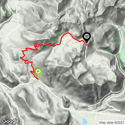
Col de la Ramaz Nord climbs 14.1 km (8.8 mi) from Mieussy, in the Giffre valley of Haute-Savoie, to the pass, gaining 977 m (3,206 ft) at a 6.9% average grade. The route runs from 638 m (2,092 ft) to 1,608 m (5,274 ft). The pass itself sits at 1,559 m (5,115 ft), and the road keeps rising a little beyond it to its high point at 1,619 m (5,312 ft). It ranks #959 on our list of the world's hardest climbs.
This is a category 1 Tour de France climb that has been crossed five times: in 1981 (Thonon-les-Bains to Morzine), 2003 (Lyon to Morzine, a stage won by Richard Virenque), 2010 (Station des Rousses to Morzine-Avoriaz, where Lance Armstrong suffered the first real crack of his Tour career), 2016 (Megève to Morzine) and 2023 (Annemasse to Morzine, Stage 14, when Wout van Aert led over the top). The Critérium du Dauphiné used it in 2024, when Marc Soler crossed first.
The character of the climb changes completely halfway up. The lower slopes wind through farms and meadows with Mont Blanc coming into view, then the road enters a rocky gorge where the steepest ramps, avalanche galleries and tunnels sit over a drop, before it eases onto the Sommand plateau and rolls to the col.
PLAN YOUR ROUTE
 We've partnered with Sherpa-Map.com to bring you the best route planning tool. With a PRO Membership you can use this climb as a reference when creating your route.
 Col de la Ramaz Nord covers 14.1 km (8.8 mi) and 977 m (3,206 ft) at a 6.9% average. The steepest 0.5 km (0.3 mi) averages 11.0%, the steepest 1 km (0.6 mi) 10.5%, the steepest 2 km (1.2 mi) 10.3%, the steepest 5 km (3.1 mi) 8.8% and the steepest 10 km (6.2 mi) 7.5%.
The first 2 km (1.2 mi) run at about 7.5% before the road flattens briefly to about 2% around 2 to 3 km, which gives your legs a short rest. The grade then returns to about 6.6% to 6.7% and builds from 6 km (3.7 mi), reaching 7.8%, 8.2%, 9.2% and a peak of 10.5% between 9 and 10 km (5.6 and 6.2 mi), through the gorge with its tunnels and galleries. Above that the Sommand plateau brings relief at 5% to 6%, with the last kilometers rolling along at 6.4% and then 4.6% to the finish. If you are pacing, treat the 4 km (2.5 mi) from 6 km to 10 km as the climb.
Roadway: The road is paved all the way, but the surface is uneven in places, especially around the tunnels and galleries in the gorge, and it is narrow with exposed edges over a drop. Some sections have been resurfaced. Bring lights for the tunnels.
Traffic: Often quiet. The road serves the Praz de Lys and Sommand ski area and the farms of the upper valley rather than a major route, so you will mostly share it with other cyclists and local cars. On certain summer Sundays the pass is closed to motor traffic. On 26 July 2026 the commune of Mieussy closed it from 08:30 to 12:30 for a free morning reserved for cyclists, hikers and rollerskaters, with a breakfast for riders and food at the col.
Parking: Mieussy is a small village of about 2,500 people in the Giffre valley, and riders start in the village center near the main roundabout, which is also the gathering point for the car-free morning on the pass.
Gear: A compact crankset is plenty, and the 6 km to 10 km stretch is where you will want the easiest gear. The climb is exposed to the sun, so many riders choose to go early in the day. Pack a light jacket for the descent and lights for the tunnels.
Provisions: There is little on the road itself, so fill your bottles in Mieussy before you set off. Check ahead for road works on the descent toward Taninges before you ride.
Before heading out on any cycling adventure check out our Things to Bring on a Cycling Trip and use our interactive check list to ensure you don't forget anything.
Mieussy is a historic center of paragliding in the Alps, and it is worth a look from the ground or the air. The commune has a late 15th-century church, Saint-Gervais, listed as a historic monument in 1926, and the Chapelle Saint-Grat, which is built on a rock about 850 m up a cliff above the hamlet of Matringes. On the other side of the pass, the Sommand plateau opens views of the Mont Blanc massif and, from the Pointe de Chalune, as far as the Jura.
The descent past Praz de Lys gives some of the best Mont Blanc views on the route. It continues through forest toward Taninges, and there is a quieter alternative through Rond. Our Col de Romme page covers a short hard climb from Cluses, and our Plateau de Solaison page covers the dead-end balcony road above Bonneville, both easy to add to a few days based in the Giffre valley. You can see other climbs nearby, or build a custom route from here, with our Routes in the Area tool.
ROUTE MAP
MEMBER RATING
CURRENT WEATHER
PJAMM TRIPS ADVENTURE STARTER BUNDLES
Check out PJAMM Adventure's prepackaged (self-guided) cycling trips. They will help you plan, document and conquer your next adventure.
NEARBY CLIMBS (0) RADIAL PROXIMITY
FROM No Climbs Found
MEMBER REVIEWS & COMMENTS
Let us know what you thought of this climb. Signup for our FREE membership to write a review or post a comment.
Already have an account?
LOG IN HERE
