
15.4
PDI
4.2 mi
DISTANCE
2,016 ft
GAINED
9.1 %
AVG. GRADE
FULL CLIMB STATS
INTRO
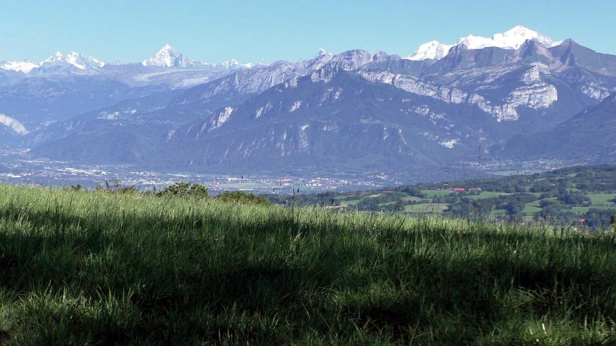
From Geneva the Salève looks like a wall, and the Croisette road is the way straight up it. This climb takes that wall and keeps going: after the col it rolls out across the open top of the mountain to a picnic table and a shaded bench called the Panorama sur les Alpes, where the view swings round to Mont Blanc, with Lake Annecy below.
The numbers are lopsided. From Le Coin the Route de la Croisette goes up through the forest at 10-12% for most of 4 km, in hairpins with almost no relief - the steepest kilometer is 12.1% and the steepest 5 km average 10.4%. That's the stretch the Tour de France climbed in July 2026; our Col de la Croisette page has the story. At the col the trees open, and the last 2.2 km along the RD41A are a different ride, 4.5-6.5% across high pasture. In all it's 6.8 km (4.2 mi) and 614 m (2016 ft) at 9.1%.
Stop at the col and you get Geneva, its lake and the Jura. Ride the extra 2 km and you're facing the Alps instead - which is the whole point of this version.
PLAN YOUR ROUTE
 We've partnered with Sherpa-Map.com to bring you the best route planning tool. With a PRO Membership you can use this climb as a reference when creating your route.
Panorama sur les Alpes Ouest is 6.8 km (4.2 mi) long and climbs from 669 m (2195 ft) at Le Coin to 1284 m (4211 ft), a gain of 614 m (2016 ft) at an average of 9.1%.
The steepest 500 m average 12.2%, the steepest kilometer 12.1%, the steepest 2 km 11.6% and the steepest 5 km 10.4%.
Km 0-1: 8.4% and then 9.9% as the road leaves Le Coin.
Km 1-4.5: 10-12% through the forest hairpins of the Route de la Croisette - no half-kilometer under 10%.
Km 4.5-6.8: 4.5-6.5% from the Col de la Croisette along the Route de l'Observatoire to the viewpoint.
Km 1-4.5: 10-12% through the forest hairpins of the Route de la Croisette - no half-kilometer under 10%.
Km 4.5-6.8: 4.5-6.5% from the Col de la Croisette along the Route de l'Observatoire to the viewpoint.
Roadway: Tarmac throughout. The Route de la Croisette (RD45) is narrow, steep and twisting, and was relaid in 2026 ahead of the Tour. Beyond the col, the Route de l'Observatoire (RD41A) is a narrow ridge road across open pasture with an older, patched surface. In winter the RD41A between La Croisette and Monnetier-Mornex is sometimes shut by snowdrifts until it's cleared, and the col turns into a small cross-country ski area, so treat this as a spring-to-autumn climb and check inforoute74.fr for closures. Take the Croisette descent slowly - its hairpins are 11-12%.
Traffic: Light to moderate on the Croisette, busiest on sunny weekends when Geneva heads for the restaurants and trails at the col. The ridge road beyond carries mostly walkers' cars and other riders.
Parking: The Le Coin car park in Collonges-sous-Salève, used by walkers heading for the Orjobet trail, is right at the start. Without a car, Geneva's TPG bus M runs to Collonges (Bourg d'en Haut stop), about 20 minutes' walk below Le Coin - or just ride out from Geneva. Don't count on a space at the col on a fine weekend.
Gear: Nearly 4 km at 10-12% leaves no room to spin up a big ratio, so we'd want a 34 on the front and at least a 32 on the back. The top of the Salève is exposed pasture and often windy, so take a layer even when Geneva is warm.
Provisions: Fill up in Collonges - there's no water on the climb. At the col, Les Marches de la Croisette has a big terrace (closed Monday and Tuesday). Farther along the ridge road toward the cable car, L'Observatoire serves simple food with a 360-degree view; check its hours before counting on it.
Before heading out on any cycling adventure check out our Things to Bring on a Cycling Trip and use our interactive check list to ensure you don't forget anything.
Collonges-sous-Salève sits right on the Swiss border, a short ride from central Geneva, so most riders stay in the city. Saint-Julien-en-Genevois, a few kilometers west, is the French alternative with a train station.
At the viewpoint there's a picnic table and a shaded bench - bring something from Collonges and sit for a while. From here the RD41A carries on along the ridge toward the Téléphérique du Salève and Monnetier-Mornex, so you can cross the mountain rather than go back down the Croisette; the road down to Monnetier has a pitch over 17%, so go carefully. Our Panorama sur les Alpes Est and Nord pages come up to the same viewpoint from La Muraz and Monnetier-Mornex, and Le Grand Piton heads south along the ridge toward the Salève's highest point.
For walkers in the group, the Orjobet trail from the Le Coin car park climbs through the cliffs past the Orjobet cave - a hard 11 km, allow four and a half hours.
ROUTE MAP

MEMBER RATING
CURRENT WEATHER
PJAMM TRIPS ADVENTURE STARTER BUNDLES
Check out PJAMM Adventure's prepackaged (self-guided) cycling trips. They will help you plan, document and conquer your next adventure.
NEARBY CLIMBS (0) RADIAL PROXIMITY
FROM No Climbs Found
MEMBER REVIEWS & COMMENTS
Let us know what you thought of this climb. Signup for our FREE membership to write a review or post a comment.
Already have an account?
LOG IN HERE
