
17.9
PDI
7.9 mi
DISTANCE
2,861 ft
GAINED
6.9 %
AVG. GRADE
FULL CLIMB STATS
INTRO
PLAN YOUR ROUTE
 We've partnered with Sherpa-Map.com to bring you the best route planning tool. With a PRO Membership you can use this climb as a reference when creating your route.
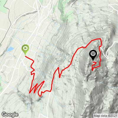
Signal des Voirons from Saint-Cergues is 12.7 km (7.9 mi) long with 872 m (2861 ft) of climbing at a 6.9% average, from 550 m (1804 ft) to 1418 m (4652 ft).
The climb comes in three parts. The paved opening is the hardest: the first four kilometers average about 8.2%, with kilometer 4 at 9.5% through the hairpins. The grade eases over kilometer 5 and almost flattens at 2.3% for kilometer 6, around where the pavement gives way to gravel.
The gravel middle section climbs more gently - kilometers 7 to 10 average about 6.2%, easing to 4.0% for kilometer 10. Once you rejoin the paved road the grade kicks back up, with the final 2.7 km averaging about 8.2% and kilometer 12 at 9.0%.
Steepest sections: 9.7% for the steepest kilometer, 9.3% for the steepest 2 km and 7.6% for the steepest 5 km. The steepest mile (1.6 km) averages 9.5%. The climb is currently ranked #1247 in the world in our database.
Roadway: This is a mixed-surface climb. The lower hairpins above Saint-Cergues are paved but narrow, and riders have described them as rough in places. From about 960 m (3150 ft) the route follows a gravel forest road for roughly 4 km - not steep, but loose in places, and it turns muddy quickly after rain and dries slowly. The last 2.5 km are on the paved Route des Voirons, which ends below the summit. A gravel bike, or a road bike with wide tires, is the right tool.
Traffic: Very light. The forest road is closed to cars, and the lower hairpins serve only a few homes. The upper paved road carries hikers' and monastery visitors' cars, mostly on weekends, but riders report seeing few vehicles even then.
Parking: Saint-Cergues is a residential village rather than a trailhead, so park considerately in the village and ride to the start. At the top, the paved Route des Voirons has a large hikers' car park near the monastery, the usual starting point for the walk along the ridge to the Signal.
Provisions: Stock up before you leave Saint-Cergues - there is nothing on the climb itself and no cafe at the top, so carry all the water and food you need. The Monastère Notre-Dame des Voirons near the top has a craft shop, but it isn't a place to refuel.
Gear: Tire choice matters more than gearing here: tires of 35 mm or wider with some tread make the gravel section and the descent far more comfortable. The paved hairpins at the start reach 9-10%, so pair them with a compact crankset and a wide-range cassette. The forest stays cool even in summer and the ridge is often breezy, so bring a layer.
Before heading out on any cycling adventure check out our Things to Bring on a Cycling Trip and use our interactive check list to ensure you don't forget anything.
The Voirons have drawn pilgrims for centuries. Louis de Langin founded the first chapel here in the 15th century to house a black Virgin, and Saint François de Sales came in 1595; after a fire, the statue was moved to the church in Boëge, where it remains. Since 1967 the top of the massif has been home to the Sisters of Bethlehem, whose Monastère Notre-Dame des Voirons (about 100 nuns) has a chapel, art studios and a craft shop open to visitors on weekday afternoons - check the hours before you go.
From the car park, the GR Balcon du Léman follows the wooded ridge to the Signal des Voirons at 1480 m (4856 ft), with a 360-degree panorama over Geneva, the Jura and the Mont Blanc chain. About 10 minutes beyond the Signal is the Saut de la Pucelle, a cliff-edge overhang, and the ridge path continues past the Col du Pralère toward the Notre-Dame du Pralère oratory on a lookout.
Back in Saint-Cergues, the Cave aux Fées hiking trail starts by a dolmen and climbs along the Chandouze torrent to the same ridge - a good way to see the mountain on foot on a rest day.
ROUTE MAP
MEMBER RATING
CURRENT WEATHER
PJAMM TRIPS ADVENTURE STARTER BUNDLES
Check out PJAMM Adventure's prepackaged (self-guided) cycling trips. They will help you plan, document and conquer your next adventure.
NEARBY CLIMBS (0) RADIAL PROXIMITY
FROM No Climbs Found
MEMBER REVIEWS & COMMENTS
Let us know what you thought of this climb. Signup for our FREE membership to write a review or post a comment.
Already have an account?
LOG IN HERE
