
17.5
PDI
6.8 mi
DISTANCE
2,673 ft
GAINED
7.5 %
AVG. GRADE
FULL CLIMB STATS
INTRO
PLAN YOUR ROUTE
 We've partnered with Sherpa-Map.com to bring you the best route planning tool. With a PRO Membership you can use this climb as a reference when creating your route.
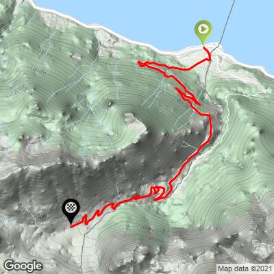
Novel - Les Planches averages 7.5% over 10.9 km (6.8 mi), with remarkably little variation.
Saint-Gingolph to Novel (km 0-8): About 564 m (1850 ft) of gain at roughly 7.1%. The first kilometer out of town is one of the steeper ones at 7.8%, and kilometers 2 through 7 hold steady at 6.8-7.5%. Kilometer 8, into the village, is the easiest at 5.9%.
Novel to La Planche (km 8-10.9): About 251 m (823 ft) of gain at roughly 8.4%, the hardest part of the climb, with kilometers of 8.2%, 8.9% and 8.1% to the end of the pavement.
The steepest kilometer averages 9.2%, the steepest 5 km (3.1 mi) average 7.8%, and the steepest 400 m reach about 10.4%.
Roadway: Paved and in good condition all the way to the hiking car park at La Planche, where the asphalt ends. The road is narrow, with several bridges over ravines on the forested middle section and tight bends through the village of Novel. Beyond La Planche, a rough dirt track climbs on toward the Col de Neuvaz at well over 20% - mountain bike or walking territory only. Snow can linger on this north-facing road into spring, so early- and late-season rides are best checked first.
Traffic: Very light. The road only serves Novel and the La Planche trailhead, and riders describe traffic as almost nonexistent. The exception is the start: the D1005 through Saint-Gingolph is the main lakeshore road between Évian and the Swiss Valais and is busy, so you will be glad to turn off it.
Parking: The easiest place to leave a car is the public car park on the Quai in Saint-Gingolph, on the lakefront a short ride from the start. Saint-Gingolph's pier is also served by Lake Geneva's CGN passenger boats all year round, which makes arriving by boat a memorable alternative. At the top, La Planche has a hiking car park if you want to start from above for a walk.
Provisions: Saint-Gingolph has shops, cafes and restaurants on both sides of the border, so stock up there - Novel is a village of a few dozen people, and La Planche is just a trailhead, so do not count on buying anything on the climb.
Gear: A compact crankset is plenty for the steady 7-8% grades. Because the road is shaded and north-facing, the descent can be cold and damp even when the lakeshore is warm, so pack a light layer. Watch for leaves, damp patches and gravel in the shaded forest corners on the way down, especially in spring and autumn.
Before heading out on any cycling adventure check out our Things to Bring on a Cycling Trip and use our interactive check list to ensure you don't forget anything.
Saint-Gingolph is a border village with a story. The Morge torrent splits it in two: until 1569 it was a single community, but the Treaty of Thonon left the land on the far side of the river to the Valais, and it has been half French and half Swiss ever since. The two halves still share one parish, which makes the Swiss side the only place in Switzerland under a foreign diocese, and the château, built in 1585-1588, became the Swiss side's town hall around 1900 and also houses a museum. On the French side, the Monument des Fusillés on the Rue du 23 Juillet 1944 marks the day in 1944 when occupying troops set fire to the village after a Resistance attack - almost the entire population of the French side fled into Switzerland.
Up the hill, Novel has its own history with its lakeside neighbor: the two communities fought over alpine pastures from the 13th to the 17th century. Its parish church dates to around 1763, with a bell tower added in 1889, and was rebuilt after a fire in 1924. A marked hiking trail links Saint-Gingolph and Novel if you want to explore on foot, and the trailhead at La Planche is a starting point for walks beneath the Cornettes de Bise.
Because the upper road faces north and holds snow, conditions at La Planche can be very different from the lakeshore in spring and autumn. Check current conditions before you go with our Weather tool.
ROUTE MAP
MEMBER RATING
CURRENT WEATHER
PJAMM TRIPS ADVENTURE STARTER BUNDLES
Check out PJAMM Adventure's prepackaged (self-guided) cycling trips. They will help you plan, document and conquer your next adventure.
NEARBY CLIMBS (0) RADIAL PROXIMITY
FROM No Climbs Found
MEMBER REVIEWS & COMMENTS
Let us know what you thought of this climb. Signup for our FREE membership to write a review or post a comment.
Already have an account?
LOG IN HERE
