
18.6
PDI
4.1 mi
DISTANCE
2,200 ft
GAINED
10.3 %
AVG. GRADE
FULL CLIMB STATS
INTRO
PLAN YOUR ROUTE
 We've partnered with Sherpa-Map.com to bring you the best route planning tool. With a PRO Membership you can use this climb as a reference when creating your route.
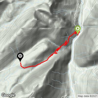
The climb averages 10.3% over 6.5 km (4.0 mi), and after the first kilometer there's very little relief. The opening kilometer along the Borne averages about 8.4%, then the gradient builds to around 9.7% in the second kilometer and roughly 11.5% through the third and fourth. A slightly easier kilometer near 9.5% follows before the hardest section of all: the sixth kilometer averages about 12.7%. The final 0.5 km (0.3 mi) eases to around 7% as you reach the end of the pavement.
The steepest 0.5 km averages 13.3%, the steepest kilometer 12.8%, the steepest 2 km 11.8% and the steepest 5 km 11.2%. Riders consistently report short ramps well beyond that - 14% and steeper - on the tighter hairpins.
Roadway: Paved the entire way to the car park at 1389 m (4,557 ft), where the asphalt ends. From there a chalky limestone gravel track runs roughly 1.3-1.8 km (0.8-1.1 mi) across the plateau to the Col des Glières, where pavement resumes for the descent to Thorens-Glières. The road was resurfaced ahead of the 2018 Tour, and rider reports through 2025 describe it as narrow but in good condition, though leaf litter and loose gravel collect at the edges. The gravel is rideable on a road bike with care, but it's slippery when wet and has sharp rocks poking through. The road isn't ploughed in winter - signs at the bottom warn that snow chains are required - so treat this as a late-spring-to-autumn climb.
Traffic: Very light. Buses, camper vans and vehicles over 8 m (26 ft) are banned from this side year-round, and riders routinely describe seeing almost no cars in the forest. Expect more traffic once you reach the plateau on summer weekends, when visitors arrive from the Thorens-Glières side for the monument and the restaurants.
Parking: Le Petit-Bornand-les-Glières is the natural place to park and start; the turn for the climb at L'Essert is a short ride up the valley. At the top, there's a car park where the pavement ends, and a larger one at the Col des Glières beside the monument and the Maison du Plateau.
Provisions: Fill up in Le Petit-Bornand or Entremont - their bakeries, cafés and fountains are your last chance before the climb. The plateau has several restaurants and mountain inns, including Chez Constance, Chez Gautard and Chez Regina, but some open only in season or on weekends, so don't count on them.
Gear: Gear low. Riders who know the climb recommend a 34x30 or 34x32 for the sustained 11-13% ramps. If you plan to cross the plateau, wider tires will help on the gravel, which can puncture tires and damage rims. The descent is steep and tight, so check your brakes before you set off.
Before heading out on any cycling adventure check out our Things to Bring on a Cycling Trip and use our interactive check list to ensure you don't forget anything.
The Plateau des Glières is a national symbol of the French Resistance. From January 1944 the maquis gathered here to receive Allied parachute drops; in March 1944, fewer than 500 fighters held the plateau against around 12,000 German troops, and those who survived dispersed after heavy losses. The maquis regrouped, and Haute-Savoie was liberated by Resistance forces alone on 19 August 1944. Émile Gilioli's National Monument of the Resistance (1973) stands near the Col des Glières, and the Memory of the Maquis building by the car park offers screenings, models and guided tours by reservation. A small memorial early on the climb itself honors fighters who died here.
The plateau is also a protected natural area of pastures, peat bogs, cliffs and forest, home to golden eagles, peregrine falcons and black grouse, with gentians and orchids in early summer. Le Grand-Bornand and the Col de la Colombière are just up the valley, and the Col des Aravis is not much farther - see other climbs nearby, or build a custom route from here, with our Routes in the Area tool.
ROUTE MAP
MEMBER RATING
CURRENT WEATHER
PJAMM TRIPS ADVENTURE STARTER BUNDLES
Check out PJAMM Adventure's prepackaged (self-guided) cycling trips. They will help you plan, document and conquer your next adventure.
NEARBY CLIMBS (0) RADIAL PROXIMITY
FROM No Climbs Found
MEMBER REVIEWS & COMMENTS
Let us know what you thought of this climb. Signup for our FREE membership to write a review or post a comment.
Already have an account?
LOG IN HERE
