
18.1
PDI
6.4 mi
DISTANCE
2,645 ft
GAINED
7.8 %
AVG. GRADE
FULL CLIMB STATS
INTRO
This climb links the valley floor of Saint-Gervais-les-Bains with Le Bettex, the ski village on the slopes of Mont d'Arbois, by a string of quiet local roads instead of the main road. Our route runs 10.4 km (6.4 mi) from Le Fayet with 806 m (2,645 ft) of gain at a 7.8% average, rising from 586 m (1,921 ft) to 1,392 m (4,566 ft).
It is steep from the very first meter and never really lets up. The Route des Amerands climbs out of Le Fayet through the hamlet of Fayet du Milieu at a steady 7-8%, then the narrow Route de Cupelin passes the hamlet's 17th-century chapel and winds up through meadows and chalets. The hardest work comes last: the final 1.3 km (0.8 mi) average more than 9% as the road joins the Route du Bettex for the finish.
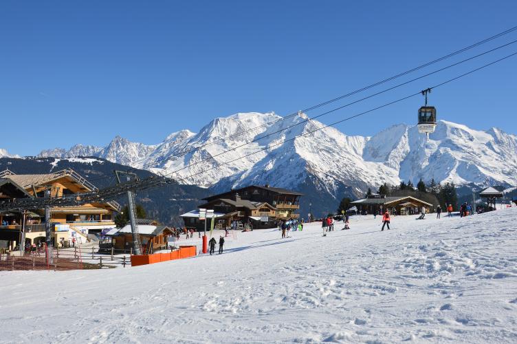
Le Bettex is a Tour de France summit finish, where Romain Bardet won in 2016 and Wout Poels in 2023. Both stages tackled the steep Côte des Amerands just before a final climb on the main roads, so this route is a quieter back way to the same finish, with the Mont Blanc massif rising above the top.
PLAN YOUR ROUTE
 We've partnered with Sherpa-Map.com to bring you the best route planning tool. With a PRO Membership you can use this climb as a reference when creating your route.
Le Fayet - Cupelin - Le Bettex climbs 10.4 km (6.4 mi) at a 7.8% average, gaining 806 m (2,645 ft) from 586 m (1,921 ft) to 1,392 m (4,566 ft).
There is no warm-up. The first 6 km (3.7 mi) hold remarkably steady between 7.0% and 7.8% per kilometer on the Route des Amerands and the lower Route de Cupelin. Kilometer 7 is the first real spike at about 9.0%, followed by a slightly easier kilometer at 7.4%.
The finish is the hardest part of the climb: kilometer 9 averages about 8.4%, kilometer 10 about 9.3%, and the last few hundred meters into Le Bettex stay above 9%. The steepest kilometer averages 9.5%, the steepest 500 m (0.3 mi) 10.3%, the steepest 2 km (1.2 mi) 9.0% and the steepest 5 km (3.1 mi) 8.5%. The steepest 91 m (100 yd) reach 11.8%.
Roadway: Paved throughout. The Route des Amerands and the Route de Cupelin are narrow local roads serving hamlets and chalets, so stay alert for oncoming cars, especially on the descent. The final stretch on the Route du Bettex is the main resort road and is wider. Le Bettex sits at about 1,400 m (4,600 ft), so expect snow on the upper road through the winter ski season.
Traffic: Light on the lower and middle sections, where the roads mostly carry residents of the hamlets. Traffic picks up on the Route du Bettex at the top, especially in July and August and in the ski season, when visitors drive up to the resort.
Parking: Le Fayet has parking near the Saint-Gervais-Le Fayet railway station, which is also the natural starting point - and the station makes it easy to arrive by train. Avoid parking along the narrow Route des Amerands itself. Le Bettex is also linked to Saint-Gervais by cable car, handy for non-riding companions meeting you at the top.
Provisions: Le Fayet has shops and cafés close to the start, and there is little along the way through Cupelin, so carry what you need. Le Bettex is a resort village with restaurants at the top, though hours are seasonal. Le Fayet also has several bike shops if you need a last-minute part or a rental.
Gear: With almost every kilometer at 7% or more and a finish above 9%, a compact crankset with a 30-32 tooth largest cog is a good idea. The descent on the narrow back roads is steep and technical, so check your brakes before you go.
Before heading out on any cycling adventure check out our Things to Bring on a Cycling Trip and use our interactive check list to ensure you don't forget anything.
The Chapelle de Cupelin, right on the climb at about 950 m (3,117 ft), is worth a stop. Villagers paid to build it in 1654, and it is dedicated to the Virgin Mary and to Saint Guérin, protector of the flocks. In 2015 it received 12 contemporary stained-glass windows by the Korean-born artist Father Kim En Joong, and a 2022 restoration revealed its original painted decoration. It is usually open daily in summer, with free entry.
Down at the start, Le Fayet's thermal park, a short walk from the station, is home to the Thermes de Saint-Gervais Mont Blanc - a good recovery stop after the ride. The station is also where the Tramway du Mont-Blanc begins its climb toward the Mont Blanc massif, a line that opened its first section in 1909. Saint-Gervais' tourist office holds the Accueil Vélo label for bike-friendly services. Several other climbs start within a few kilometers of Le Fayet - see them, or build a custom route from here, with our Routes in the Area tool.
ROUTE MAP

MEMBER RATING
CURRENT WEATHER
PJAMM TRIPS ADVENTURE STARTER BUNDLES
Check out PJAMM Adventure's prepackaged (self-guided) cycling trips. They will help you plan, document and conquer your next adventure.
NEARBY CLIMBS (0) RADIAL PROXIMITY
FROM No Climbs Found
MEMBER REVIEWS & COMMENTS
Let us know what you thought of this climb. Signup for our FREE membership to write a review or post a comment.
Already have an account?
LOG IN HERE
