
17.5
PDI
7.6 mi
DISTANCE
2,823 ft
GAINED
6.7 %
AVG. GRADE
FULL CLIMB STATS
INTRO
PLAN YOUR ROUTE
 We've partnered with Sherpa-Map.com to bring you the best route planning tool. With a PRO Membership you can use this climb as a reference when creating your route.
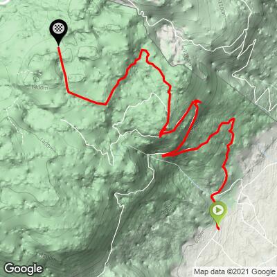
The Col de Combe Blanche from Divonne-les-Bains is 12.3 km (7.6 mi) long with 860 m (2823 ft) of gain at a 6.7% average, from about 577 m (1894 ft) to about 1392 m (4566 ft). The total gain is a little more than the height difference because of a short descent partway up.
The first 7 km do almost all the work: about 815 m of the gain at close to 9%, with every kilometer from the second to the seventh between 8% and 10.5%. The steepest 5 km average 9.2%, the steepest 2 km 9.7%, the steepest kilometer 9.9% and the steepest 0.5 km 11.7%.
After about km 7 the road flattens, dips briefly, then climbs at 4-6.5% for most of the remaining 5 km. The last kilometer is close to flat, so the col arrives more gently than the start would suggest.
Roadway: A narrow, single-lane forest road, paved but rough: riders describe gritty, patched asphalt with loose stones, potholes and the occasional fallen branch, getting worse toward the top. It's fine going up and poor going down, so most riders continue past the col on forest roads toward La Vattay and descend by the Col de la Faucille instead. The road isn't cleared in winter and riders have found it barred from December to mid-June, and the forest roads around the col sit in a wildlife quiet zone of the Haute Chaîne du Jura nature reserve from mid-December to the end of June. Plan on July through autumn.
Traffic: Almost none. Most reports mention one car or none at all; forestry vehicles and the odd warden are the main traffic. It's the opposite of the busy Faucille road a few kilometers south.
Parking: There's no lot at the foot of the climb. Park in Divonne-les-Bains and ride the 2 km or so up through the lanes on the edge of town - the climb is signposted from the Route de l'Etraz above the center, though riders still say the start is easy to miss.
Gear: Gear for the first 7 km, not the average - close to 9% for that long makes a compact with a 30- to 32-tooth cog a good idea. Tires of 28 mm or more help on the broken surface, and good brakes and patience matter if you do descend this side.
Provisions: Nothing on the climb and nothing at the col. Fill up in Divonne-les-Bains, which has bakeries, cafes and supermarkets. If you loop back over the Faucille, there are places to eat at the top of that pass.
Before heading out on any cycling adventure check out our Things to Bring on a Cycling Trip and use our interactive check list to ensure you don't forget anything.
Divonne-les-Bains is a spa town with a casino, a racecourse and a lake on the edge of town, and it's only about 20 km from Geneva. It makes an easy base, and the Swiss border is right on the edge of town, so many riders come in straight from Nyon or Geneva.
The natural day out is a loop: up Combe Blanche, across on the forest roads past La Vattay, and down the Col de la Faucille, which has its own pages on our site. Gravel riders extend it the other way, past Combe Blanche into Switzerland on the forest tracks toward La Rippe, with about a kilometer of stony track on the way. A western variant climbs from Vesancy and joins partway up - steeper, rougher and just as empty.
ROUTE MAP
MEMBER RATING
CURRENT WEATHER
PJAMM TRIPS ADVENTURE STARTER BUNDLES
Check out PJAMM Adventure's prepackaged (self-guided) cycling trips. They will help you plan, document and conquer your next adventure.
NEARBY CLIMBS (0) RADIAL PROXIMITY
FROM No Climbs Found
MEMBER REVIEWS & COMMENTS
Let us know what you thought of this climb. Signup for our FREE membership to write a review or post a comment.
Already have an account?
LOG IN HERE
