

48.8
PDI
35.7 mi
DISTANCE
10,066 ft
GAINED
3.6 %
AVG. GRADE
FULL CLIMB STATS
Page Contributor(s): Rob McLarty, Toronto, Canada
INTRO
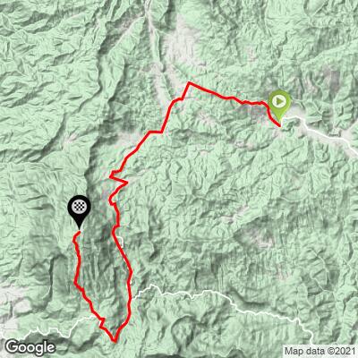
Doi Inthanon (Mae Wang) is a remote back-road ascent of Doi Inthanon - Thailand's highest peak - approached from the west via Amphoe Mae Wang rather than the standard tourist route through the park's main checkpoint on Route 1009. Over 35.7 miles the route climbs 10,066' of total elevation gain (including about 3,334' of descending along the way) to reach 8,372' near the summit, and currently ranks as the hardest bike climb in Thailand and #45 in the world in our database.
In the words of contributor Rob McLarty, who rode it after hearing other climbers talk about it: "It's steep, it's remote, it's a lot of up and down, and it's hot. This pass is a collection of ramps between 10 and 25%. One of the ramps must have been over 30% - I can't be sure because the GPS is pretty wonky out there, but I was walking while watching trucks struggling to maintain momentum." Much of the route runs through rural farmland and forest on quiet roads before joining the high-altitude terrain near Doi Inthanon's summit.
Current riders should know: as of January 2023, Doi Inthanon National Park requires all cyclists to be accompanied by a support (SAG) vehicle, and riding downhill anywhere in the park is strictly forbidden. Those rules were announced for the park's main paved approaches, but given this route also finishes near the summit inside the park, treat the same requirements as applying here - arrange a SAG vehicle before you go, and plan to be driven back down rather than descending by bike. We haven't found confirmation these rules have changed since 2023, but confirm current status with a local operator before you commit to this ride.
PLAN YOUR ROUTE
 We've partnered with Sherpa-Map.com to bring you the best route planning tool. With a PRO Membership you can use this climb as a reference when creating your route.
 The descent on this route dramatically reduces its PDI score. Removing the descent and calculating just ascent raises the average grade from 3.6% to 7.8% for just the climb portion. Steepest quarter mile is 22% and there is a full mile at 15%.
Roadway: This route runs almost entirely on quiet rural and forestry roads through Amphoe Mae Wang before finishing near Doi Inthanon's summit - a mix of paved farm roads and rough, largely unpaved stretches, with sections steep enough (reportedly over 30% in spots) that even motor vehicles struggle for traction. This is not the maintained, double-lane highway used by the standard Doi Inthanon route (Route 1009) - expect a rougher, remote backcountry road for most of the distance.
Traffic: Very light for most of the route - this is farmland and forest, not a tourist corridor. Traffic increases near the top as the route nears the main park infrastructure around the summit.
Parking: There's no formal trailhead. Most riders base out of Chiang Mai (about 60 km away) and arrange transport/SAG support to and from the start in Tambon Mae Win. Given the current SAG requirement for cycling in Doi Inthanon National Park (see Intro), plan your staging around wherever your support vehicle meets you rather than expecting a dedicated lot.
This is a climb best for a gravel bike - the unpaved sections are rough enough, and steep enough, that wide, grippy tires and low gearing matter. Bring far more water and food than you think you'll need: this route is hot, remote, and has few if any reliable places to resupply along the way. A support (SAG) vehicle is not just recommended here, it's currently required by Doi Inthanon National Park - arrange one before you start, both for the park rule and for basic safety on a route this isolated.
Before heading out on any cycling adventure check out our Things to Bring on a Cycling Trip and use our interactive check list to ensure you don't forget anything.
Chiang Mai is the natural base for this climb, roughly 60 km (about 1.5-2 hours by road) from the start in Tambon Mae Win. Given the SAG requirement and the remoteness of this route, most riders arrange a support vehicle and driver out of Chiang Mai rather than attempting logistics on their own - see our Doi Inthanon Cycling Resource Guide for a support-driver recommendation that's worked well for other PJAMM riders in the area. If you're making a trip of it, Doi Inthanon National Park's waterfalls and the summit's Royal Pagodas are worth visiting beyond the ride itself, and Doi Suthep, closer to Chiang Mai, is another notable climb worth combining with this trip.
ROUTE MAP
MEMBER RATING
CURRENT WEATHER
PJAMM TRIPS ADVENTURE STARTER BUNDLES
Check out PJAMM Adventure's prepackaged (self-guided) cycling trips. They will help you plan, document and conquer your next adventure.
NEARBY CLIMBS (0) RADIAL PROXIMITY
FROM No Climbs Found
MEMBER REVIEWS & COMMENTS
Let us know what you thought of this climb. Signup for our FREE membership to write a review or post a comment.
Already have an account?
LOG IN HERE
