
24
PDI
6.6 mi
DISTANCE
3,140 ft
GAINED
9 %
AVG. GRADE
FULL CLIMB STATS
INTRO
Super Lescun is two climbs stacked into 10.6 km (6.6 mi): a proper mountain-pass road from the floor of the Aspe valley up to the village of Lescun, then a narrow, brutally steep lane above the village to the Refuge de l'Abérouat. Altogether it gains 957 m (3,140 ft) at a 9.0% average - and the finish is by far the hardest part.
The first 5.3 km (3.3 mi) on the D239 average about 7.8% through two sets of hairpins and past an avalanche shelter before squeezing between the stone houses of Lescun at around 905 m (2,969 ft). Above the village the road becomes a single-lane mountain lane with constant changes in gradient: a 15% wall just out of town, a brief breather on a pastoral plateau beneath the cliffs of the Billare, then a final 2.6 km (1.6 mi) at around 12.4%, with ramps that touch 16-17%.
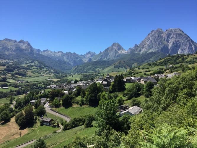
The reward is the view. For most of the climb you're looking straight into the Cirque de Lescun, a ring of limestone peaks including the Pic d'Anie and the Aiguilles d'Ansabère that ranks among the most striking sights in the western Pyrenees. The road ends at the terrace of the Refuge de l'Abérouat, a mountain lodge on the GR 10 trail.
PLAN YOUR ROUTE
 We've partnered with Sherpa-Map.com to bring you the best route planning tool. With a PRO Membership you can use this climb as a reference when creating your route.
 The climb covers 10.6 km (6.6 mi) and gains 957 m (3,140 ft) at an average of 9.0%.
From Pont de Lescun to the village (about 5.3 km / 3.3 mi) the grade averages roughly 7.8% and behaves like a classic col, including about 4 km in a row near 9% and a 10% stretch alongside an avalanche shelter. Above the village the road is far more irregular, with steep walls, short flats and even brief dips, and the very last kilometer climbs in stair-like steps right up to the refuge.
The steepest kilometer averages 14.4%, the steepest 2 km 13.2%, and the steepest 0.5 km 15.6%, with short pitches over 17%.
Roadway: The D239 up to Lescun is a regular mountain road in reasonable condition. Above the village, the lane to the Abérouat is narrow and the surface is rough in places, according to recent rider reports - with gradients this steep, take the descent slowly and make sure your brakes are in good shape. The way to the refuge isn't always well signed through Lescun: from the small square by the mairie, follow the signs for l'Abérouat, keep left at the fork just beyond, then turn sharp right at the next junction.
Traffic: Light. The lower road carries mostly local and hiker traffic into Lescun, and above the village you'll share the single lane with the occasional car heading for the refuge trailhead - and quite often with flocks of sheep.
Parking: Bedous, a few kilometers down-valley and home to the Aspe valley tourist office, is the practical place to leave a car; ride up the N134 through the Défilé d'Esquit as a warm-up, keeping in mind that the N134 carries through traffic toward the Somport. There's a small car park at the top of the climb, just below the refuge.
Provisions: Lescun has a water point on the small square by the mairie, right at the halfway mark - top up there before the hard part. At the top, the Refuge de l'Abérouat offers meals (open mid-February to late October in 2026). Bedous is the nearest town with full services.
Gear: Gear low. A compact crankset with a 32- or 34-tooth cog is a sensible minimum for the final kilometers above 12%, and good brakes - ideally discs - make the descent far less stressful.
Before heading out on any cycling adventure check out our Things to Bring on a Cycling Trip and use our interactive check list to ensure you don't forget anything.
The Aspe valley is the wildest of the Béarn's big valleys, and Lescun is its most photogenic village. Bedous is the natural base, with the valley's tourist office and a TER rail link from Pau via Oloron-Sainte-Marie on the reopened Pau-Canfranc line; bikes ride in dedicated spaces, subject to availability. Lescun itself sits on the GR 10 and is the jumping-off point for hikes to the Lac de Lhurs, the Pic d'Anie and the Aiguilles d'Ansabère - the refuge at the top of this climb is as much a trailhead as a finish line.
Other rides nearby include the quieter side road to the hamlets of Lhers, which branches off this same climb below Lescun, and the long N134 climb to the Col du Somport on the Spanish border. See what else is within reach of Bedous with our Routes in the Area tool.
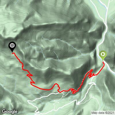
ROUTE MAP
MEMBER RATING
CURRENT WEATHER
PJAMM TRIPS ADVENTURE STARTER BUNDLES
Check out PJAMM Adventure's prepackaged (self-guided) cycling trips. They will help you plan, document and conquer your next adventure.
NEARBY CLIMBS (0) RADIAL PROXIMITY
FROM No Climbs Found
MEMBER REVIEWS & COMMENTS
Let us know what you thought of this climb. Signup for our FREE membership to write a review or post a comment.
Already have an account?
LOG IN HERE
