
17.5
PDI
6.4 mi
DISTANCE
2,608 ft
GAINED
7.7 %
AVG. GRADE
FULL CLIMB STATS
INTRO
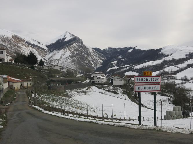
Béhorléguy has 66 residents, and the road out the top of the village goes straight up. Stand by the church and you can see the first ramp - riders put it at 14-16% - and from there the D117 doesn't really let up for 4 km. By the time it does, you're out of the trees and onto the bare grassland of the Arbailles, with sheep on the road, vultures overhead and the Pic de Béhorléguy looming above.
From Mendive it's 10.3 km (6.4 mi) and 795 m (2608 ft) of climbing at 7.7%, to finish at about 1064 m. The first 3 km are gentle - a flat start along the valley and then 7-8% into Béhorléguy. Then comes the work: about 4 km at nearly 11%, with the steepest kilometer at 12.2%. It eases to 6-9% as the landscape opens, and the last kilometer is almost flat along the crest.
It's a properly wild place. Wind sweeps the top - one rider reported 90 km/h gusts in late September - and on a grey day the col looks more like the west of Ireland than the south of France. On a clear one you can see east to the Pic d'Anie and back down the Laurhibar valley toward Saint-Jean-le-Vieux. Expect very few cars, plenty of sheep, and maybe a tractor hauling manure.
PLAN YOUR ROUTE
 We've partnered with Sherpa-Map.com to bring you the best route planning tool. With a PRO Membership you can use this climb as a reference when creating your route.
The Col de Landerre from Mendive is 10.3 km (6.4 mi) long with 795 m (2608 ft) of gain at a 7.7% average, from about 275 m (902 ft) to about 1064 m (3492 ft).
The first kilometer along the valley floor is barely 3%, and the next two climb at 7-8% into Béhorléguy. Above the village the grade jumps: from about km 3 to km 7 the road averages close to 11%, with a short ramp of around 15% just past the church. The steepest 0.5 km is 13.1%, the steepest kilometer 12.2%, the steepest 2 km 11.5% and the steepest 5 km 10.8%.
From about km 7 the slope relents to 9% and then 6%, and the final 1.3 km along the open crest gain only about 20 m, so you roll into the col rather than sprint for it.
Roadway: Paved throughout, but this is a single-lane Basque mountain road with a worn, patched surface in places and sheep and cattle droppings on the upper half. The steep middle section is fine to climb and technical to descend, so take it slowly on the way down. Snow can sit on the upper road in winter.
Traffic: Very light. Riders often report no cars at all above Béhorléguy. What you will meet is livestock on the road and, in season, tractors working the pastures - they share the narrow road on the 10-13% sections, so give them room.
Parking: The climb starts in Mendive, the same spot as our Ahusquy (Mendive) climb, and that page covers parking in the village and the Saint-Jean-le-Vieux option. Béhorléguy itself is too small for anything but a couple of cars, so don't plan on starting there.
Gear: The 4 km at nearly 11% above Béhorléguy is the reason for low gears - riders report dropping to a 34x32 on the steepest pitch, and that's sensible. The top is completely exposed, so bring a wind layer even in July.
Provisions: Nothing to buy in Béhorléguy or on the climb. Fill up in Saint-Jean-le-Vieux or Saint-Jean-Pied-de-Port before you drive in, and carry enough for the whole ride if you're carrying on toward Ahusquy.
Before heading out on any cycling adventure check out our Things to Bring on a Cycling Trip and use our interactive check list to ensure you don't forget anything.
The col sits on the western edge of the Arbailles, a limestone plateau full of sinkholes. A little over a kilometer further on is the Col d'Aphanize, and near it the Gouffre d'Aphanize, a karst shaft open to the sky - worth a stop. Red kites and vultures work the ridge above the Pic de Béhorléguy, and the pastures are dotted with cayolars, the stone shepherds' huts still used in summer.
For a loop, keep going: the D117 runs on past Aphanize for about 3 km to join the Ahusquy road, and you can drop back to Mendive the way our Ahusquy (Mendive) climb comes up, for roughly 24 km (14.9 mi) in all. That page and our Col de Burdincurutcheta page cover the Ahusquy inn, Mendive's church and the Iraty forest, so we'll leave those to them. Saint-Jean-Pied-de-Port, about 20 minutes away by car, is the place to stay.
ROUTE MAP

MEMBER RATING
CURRENT WEATHER
PJAMM TRIPS ADVENTURE STARTER BUNDLES
Check out PJAMM Adventure's prepackaged (self-guided) cycling trips. They will help you plan, document and conquer your next adventure.
NEARBY CLIMBS (0) RADIAL PROXIMITY
FROM No Climbs Found
MEMBER REVIEWS & COMMENTS
Let us know what you thought of this climb. Signup for our FREE membership to write a review or post a comment.
Already have an account?
LOG IN HERE
