
25.9
PDI
5.9 mi
DISTANCE
3,154 ft
GAINED
10 %
AVG. GRADE
FULL CLIMB STATS
INTRO
Col d'Elhursaro climbs out of Arnéguy, a small Basque border village in the Pyrénées-Atlantiques, and by our own climb database it's the steepest paved road in France. From the edge of the village the route covers 9.4 km (5.9 mi) and gains 961 m (3,154 ft) at a 10.0% average grade, topping out at 1,193 m (3,915 ft).
The numbers undersell how relentless it feels. The steepest kilometer averages 16.7%, and the opening quarter-mile out of the village spikes to 17.9% before the road has any chance to settle into a rhythm - this is the second-steepest one-mile stretch anywhere in the country. There's no warm-up here; expect to be out of the saddle within the first few hundred meters.
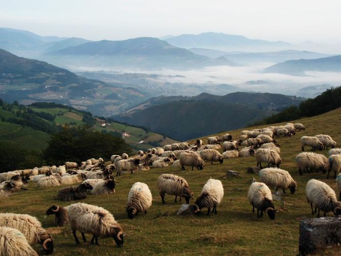
Above the lower switchbacks the trees thin into classic inner-Basque terrain: open, treeless pasture grazed by sheep and semi-wild pottok ponies, with vultures circling overhead and almost no traffic beyond an occasional farm vehicle. It's a wild, quiet ride that feels far removed from the busier Pyrenean cols further east.
Arnéguy itself has centuries of history as a frontier town. It lies on a variant of the Camino de Santiago, just across the border from Valcarlos/Luzaide and the pass at Roncesvalles, and for generations was the main customs checkpoint between France and Navarre.
PLAN YOUR ROUTE
 We've partnered with Sherpa-Map.com to bring you the best route planning tool. With a PRO Membership you can use this climb as a reference when creating your route.
 This is the steepest paved climb in France, and the second-steepest one-mile stretch in the country, by our own climb rankings. From Arnéguy the route runs 9.4 km (5.9 mi) and gains 961 m (3,154 ft) at a 10.0% average grade, starting at 254 m (835 ft) and finishing at 1,193 m (3,915 ft).
There's no gradual build-up. The steepest kilometer comes early and averages 16.7%, with the opening quarter-mile spiking to 17.9%. The first mile overall averages 15.2%, the first 2 km averages 15.2% as well, and even the steepest 5 km stretch - which covers most of the route - still averages 10.6%. Bring compact gearing and plan for a steady, unbroken effort rather than the rolling rhythm of a longer alpine col.
Roadway: The D428 is paved the entire way, but it's a narrow mountain lane, not a highway - rider reports describe patchy, granular asphalt that's rougher than most other Pyrenean climbs, occasionally dirtied by livestock crossing near the upper pastures. Some sections have reportedly been resurfaced in recent years, so expect a mix of decent and rough pavement rather than a smooth roll throughout - check recent trip reports before you go.
Traffic: Traffic is minimal - this is a farm and shepherd's road with almost no through-traffic, just the occasional local vehicle or livestock truck. There are few signs and few landmarks along the way, which adds to the remote feel.
Parking: Arnéguy is a small village, and roadside parking is available near the village center and church, close to where the D428 turns uphill. Space is limited, so arrive early if visiting during a busy summer weekend on the Camino de Santiago route through town.
Arnéguy has a small grocery and a couple of cafés near the village center that serve pilgrims walking the Camino de Santiago, so it's a reasonable spot to fuel up before or after the climb - but there's nothing at all once you leave the village, and no services anywhere on the mountain itself. Fill your bottles and eat before you start.
Given the grade, gear low. A compact crankset paired with a wide-range cassette (34-tooth or larger) is strongly recommended; sustained pitches near 17% make this one of the harder climbs in France to grind up on standard gearing. The surface is rough enough in places that slightly wider tires (28mm or up) run at lower pressure will help smooth out the ride, and disc brakes are a real asset on the steep, occasionally rough-surfaced descent back down.
Before heading out on any cycling adventure check out our Things to Bring on a Cycling Trip and use our interactive check list to ensure you don't forget anything.
Arnéguy sits right on the France-Spain border in French Basque Country, about 8 km south of Saint-Jean-Pied-de-Port, itself a good base for a multi-day trip with more services, lodging, and several other notable Basque climbs within reach. The village's history as a customs post is still visible in a couple of old border-control buildings near the bridge over the Nive d'Arnéguy.
Because Arnéguy is a stop on the Camino de Santiago (the route continues over the border to Roncesvalles/Orreaga in Spain), it has more lodging and dining options than its small size would suggest, including pilgrim-oriented gîtes and a couple of family-run restaurants - though it's worth booking ahead in peak pilgrimage season (spring through early fall).
Two other PJAMM-mapped climbs also start from this same village - Col d'Elhursaro's other approach and Alto de Beillurti - so a rider based here for a day or two can string together a genuinely quiet, traffic-free loop of Basque mountain roads. See our Routes in the Area tool for other nearby climbs worth combining into a longer day.
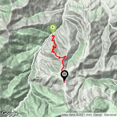
ROUTE MAP
MEMBER RATING
CURRENT WEATHER
PJAMM TRIPS ADVENTURE STARTER BUNDLES
Check out PJAMM Adventure's prepackaged (self-guided) cycling trips. They will help you plan, document and conquer your next adventure.
NEARBY CLIMBS (0) RADIAL PROXIMITY
FROM No Climbs Found
MEMBER REVIEWS & COMMENTS
Let us know what you thought of this climb. Signup for our FREE membership to write a review or post a comment.
Already have an account?
LOG IN HERE
