
24.3
PDI
7.8 mi
DISTANCE
3,461 ft
GAINED
8.1 %
AVG. GRADE
FULL CLIMB STATS
INTRO
Alto de Beillurti is one of the steepest and wildest road climbs in the French Basque Country. It starts on the Route de Pagola just outside Arnéguy, a small village right on the Spanish border, and climbs 12.6 km (7.8 mi), gaining 1,055 m (3,461 ft) at an 8.1% average grade to finish at 1,238 m (4,063 ft) on the high frontier ridge below the Col d'Arnostéguy. It ranks #82 in France and #617 in the world by our rankings.
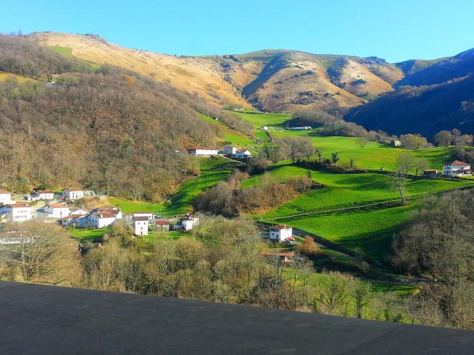
That average badly undersells the first two-thirds. Every kilometer from the bottom to km 6 averages between 9.1% and 11.8%, the steepest kilometer averages 13.7%, and short ramps spike past 25%. The road climbs through woods above the Arnéguy valley via the hamlet of Pagola, then breaks out into open pasture where Manech sheep and semi-wild pottok ponies graze right up to the tarmac. Just past km 8 you top out beside the Pic de Beillurti, dip briefly to the Col d'Heganzo, then roll up a far gentler final 3.5 km past the Col d'Elhursaro to the ridge, with views across the Nive valleys and down into Spanish Navarre.
This is a web of shepherds' lanes rather than a through route, so it's almost completely free of traffic, and the upper kilometers are shared with our Col d'Elhursaro (Arnéguy) climb. The ridge is fully exposed and riders regularly report strong wind and fog on top - check current conditions with our Weather tool before you head up.
PLAN YOUR ROUTE
 We've partnered with Sherpa-Map.com to bring you the best route planning tool. With a PRO Membership you can use this climb as a reference when creating your route.
 Alto de Beillurti climbs 12.6 km (7.8 mi) and gains 1,055 m (3,461 ft) at an 8.1% average, from 226 m (741 ft) to 1,238 m (4,063 ft), with about 43 m (140 ft) of descending along the way.
The climb splits cleanly in two. The first 8.5 km (5.3 mi) to the Pic de Beillurti is where all the damage happens: km 1 through 6 each average between 9.1% and 11.8%, the steepest 2 km average 12.5%, the steepest kilometer 13.7%, the steepest 0.5 km 16.1%, and the single steepest 100 m (0.1 mi) pitch hits 25.5%. The steepest 5 km average 10.7%.
Past the Pic the road drops briefly to the Col d'Heganzo, and the last 3.5 km (2.2 mi) to the ridge ease to roughly 4-8% - a welcome chance to spin after the wall below.
Roadway: The route is paved, but it's a narrow single-lane farm road rather than a proper highway, and the surface varies. Rider reports range from freshly resurfaced sections to patches of broken, gravelly asphalt around the Pic de Beillurti, and the steepest pitches can be slippery when damp. Several of the lanes off this ridge are extremely steep, so take real care if you descend back to the valley the way you came.
Traffic: Very light. These lanes serve a handful of farms and summer pastures, so an occasional farm vehicle or a flock of sheep on the move is about all you'll meet. Livestock grazes unfenced on the upper slopes.
Parking: There's no dedicated lot where the Route de Pagola begins, so park in Arnéguy's village center and roll the short distance to the start - or skip the car and ride in from Saint-Jean-Pied-de-Port, about 8 km (5 mi) down the Nive valley, which doubles as a warm-up before the wall.
Gear: Gearing is the whole story here. With sustained 11-13% kilometers and ramps past 25%, a compact crankset with a 34-tooth or larger cog is the minimum most riders will want, and even then the steepest early pitches are a grind at walking pace. Slightly wider tires (28 mm or more) help traction on the steep, sometimes gritty surface, and the exposed ridge calls for a windproof layer even in summer.
Provisions: There's no water or food anywhere on the climb. Fill your bottles and eat in Saint-Jean-Pied-de-Port or Arnéguy before you start.
Before heading out on any cycling adventure check out our Things to Bring on a Cycling Trip and use our interactive check list to ensure you don't forget anything.
Arnéguy sits on the Nive d'Arnéguy right at the Spanish border - our Col d'Elhursaro (Arnéguy) page covers the village's Camino de Santiago and customs-post history, so here's what else is worth knowing if you're basing yourself in the valley.
For a bed right in the village, Le Clementenia is a guesthouse with a garden on the river, on the Camino route and a short roll from the start. Across the bridge is Valcarlos (Luzaide) in Spanish Navarre - it's the village you'll look straight down on from the Pic de Beillurti.
From the Col d'Heganzo you can pick out the site of the Château-Pignon redoute on the neighboring ridge, a fortification first built in the early 1500s that changed hands between French and Spanish forces more than once and saw fighting again in 1813, when Wellington's army clashed with Marshal Soult's French troops. Strong riders can link this ridge to the Col d'Arnostéguy and the Iraty side for a big day on some of the steepest, emptiest roads in the Pyrenees.
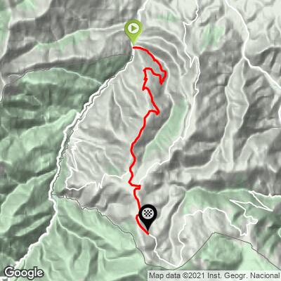
ROUTE MAP
MEMBER RATING
CURRENT WEATHER
PJAMM TRIPS ADVENTURE STARTER BUNDLES
Check out PJAMM Adventure's prepackaged (self-guided) cycling trips. They will help you plan, document and conquer your next adventure.
NEARBY CLIMBS (0) RADIAL PROXIMITY
FROM No Climbs Found
MEMBER REVIEWS & COMMENTS
Let us know what you thought of this climb. Signup for our FREE membership to write a review or post a comment.
Already have an account?
LOG IN HERE
