
26.1
PDI
13.1 mi
DISTANCE
4,393 ft
GAINED
6.3 %
AVG. GRADE
FULL CLIMB STATS
INTRO
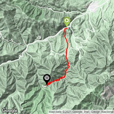
Col de Mantet climbs 21.0 km (13.1 mi) from the fortified town of Villefranche-de-Conflent to the pass at 1,764 m (5,786 ft), gaining 1,339 m (4,393 ft) at an average grade of 6.3%. It's widely rated one of the toughest and longest climbs in the Pyrénées-Orientales, and it's unusual for a real mountain pass: the road beyond the col serves only the tiny village of Mantet and dead-ends a few kilometers later, so there's essentially no through traffic at any point.
The climb breaks into three distinct sections. From Villefranche-de-Conflent to Sahorre (about 7 km) the grade is gentle, around 4%. From Sahorre to the village of Py (about 5.5 km) it firms up to roughly 5.5%. The real climb starts leaving Py - the final 9 km to the summit average 8.2% with several sustained ramps at 14-16%, the steepest full kilometer coming in at 11.8% and short pitches touching over 22%.
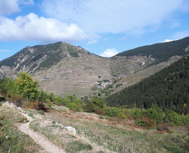
Villefranche-de-Conflent itself is worth a look before or after the ride - its 17th-century Vauban fortifications are UNESCO-listed, and it's also the starting point of the narrow-gauge "Little Yellow Train" up the Cerdagne valley. From the summit of Col de Mantet, the view opens up toward the Canigou massif, the sacred peak of Catalonia, with the road dropping away into the remote, sparsely populated Mantet valley beyond.
PLAN YOUR ROUTE
 We've partnered with Sherpa-Map.com to bring you the best route planning tool. With a PRO Membership you can use this climb as a reference when creating your route.
 Col de Mantet gains 1,339 m (4,393 ft) over 21.0 km (13.1 mi) at an average grade of 6.3%, starting at 454 m (1,489 ft) in Villefranche-de-Conflent and topping out at 1,764 m (5,786 ft).
The climb is heavily back-loaded. The first 7 km to Sahorre average only around 4%, and the next 5.5 km to Py add up to roughly 5.5% - a long warm-up before the real difficulty begins. From Py to the summit, 9 km averages 8.2%, with multiple ramps in the 14-16% range and the single steepest 100 meters on the climb reaching 22.3%. The steepest full kilometer, around km 15-16, averages 11.8%.
There is little flat ground anywhere after Py to recover on, so riders who arrive at the village already fatigued from the lower slopes tend to struggle on the steepest pitches above it.
Roadway: The D6 is paved the entire way to the col and on to Mantet village. Surface quality varies by section - the lower stretch between Villefranche-de-Conflent and Py has patchy, uneven asphalt in places per recent rider reports, while the upper section from Py to the summit has been resurfaced more recently and rides noticeably better. Expect some loose gravel and small potholes on the descent regardless of direction, especially above Py. Like most high Pyrenean roads, it closes with snow in winter.
Traffic: Very light. The D6 beyond Py is a dead end serving only the tiny village of Mantet (year-round population in the low double digits), so there is essentially no through traffic - riders consistently describe this as one of the quietest major climbs in the Pyrénées-Orientales.
Parking: Most riders start from Villefranche-de-Conflent, parking for free near the train station or around the fortified old town. Riders looking for a shorter, steeper ride can instead start from Sahorre or Py, both of which have informal roadside parking.
Villefranche-de-Conflent has grocery stores, bakeries, and cafes for stocking up before the ride. Beyond that, options are sparse: Sahorre and Py both have small shops, and Py has a public drinking-water fountain right on the route, a useful refill point before the hardest 9 km begin. There is nothing beyond Py until the tiny village of Mantet itself, so carry enough food and water for the final push, especially in summer heat with little shade on the steepest pitches.
Before heading out on any cycling adventure check out our Things to Bring on a Cycling Trip and use our interactive check list to ensure you don't forget anything.
Villefranche-de-Conflent is a genuine detour-worthy stop in its own right - a UNESCO-listed Vauban fortress town with a walkable old quarter, and the southern terminus of the narrow-gauge "Train Jaune" (Little Yellow Train) that climbs into the Cerdagne. It makes a good base for a multi-day trip in the eastern Pyrenees, with several other serious climbs within a short drive - see our Routes in the Area tool for what else is nearby. The village of Mantet beyond the col is worth the short additional descent for anyone with time: a handful of stone houses in a genuinely remote alpine bowl, with a small stream to cool off in before the long ride back.
ROUTE MAP
MEMBER RATING
CURRENT WEATHER
PJAMM TRIPS ADVENTURE STARTER BUNDLES
Check out PJAMM Adventure's prepackaged (self-guided) cycling trips. They will help you plan, document and conquer your next adventure.
NEARBY CLIMBS (0) RADIAL PROXIMITY
FROM No Climbs Found
MEMBER REVIEWS & COMMENTS
Let us know what you thought of this climb. Signup for our FREE membership to write a review or post a comment.
Already have an account?
LOG IN HERE
