
22.4
PDI
12.3 mi
DISTANCE
3,927 ft
GAINED
6 %
AVG. GRADE
FULL CLIMB STATS
INTRO
PLAN YOUR ROUTE
 We've partnered with Sherpa-Map.com to bring you the best route planning tool. With a PRO Membership you can use this climb as a reference when creating your route.
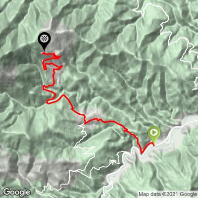
 Col de la Descarga climbs 19.8 km (12.3 mi) from 303 m (993 ft) to 1,486 m (4,876 ft), gaining 1,197 m (3,927 ft) at an average grade of 6.0%.
The climb splits into clear sections. The first 5.9 km (3.7 mi) to the area of Corsavy gain 458 m (1,503 ft) at about 7.7%. The next 7.7 km (4.8 mi) are the long false-flat, gaining just 277 m (909 ft) at about 3.6%. The road then steepens, with 4.1 km (2.5 mi) at 6.9%, and the final 2.0 km (1.2 mi) average 8.2%.
The steepest 100 yards (91 m) average 14.6%, the steepest half-kilometer 11.7%, the steepest kilometer 9.7%, the steepest 5 km 8.0% and the steepest 10 km 6.2%.
Roadway: The road is paved and generally in good shape for the region, with nine hairpins along the way. Some small gravel collects in the corners near the top, so take care on the final kilometers beyond the col. In winter a gate may be closed, though cyclists can normally get around it. The descent is steep and technical, with tight turns that call for careful braking.
Traffic: Traffic is calm. This is a dead-end road, so you will mostly share it with the occasional local car and other cyclists.
Parking: Arles-sur-Tech is the main town of the upper Vallespir, with roughly 2,800 residents. Park in the town center and spin the short distance to the start on the edge of town at 303 m (993 ft). At the top, the Batère refuge has a small bar-restaurant.
Provisions: Corsavy is the last village on the route, and the Batère refuge at the top runs a small bar-restaurant. Carry enough water and food for the long middle section, since services are sparse.
Gear: A compact with a 34x34 or easier low gear is comfortable for the steeper sections. Watch your tires on the small gravel in the upper corners. The finish is about 1,180 m (3,871 ft) above the start, so typically 8 C (14 F) cooler, and the technical descent makes a windproof layer worthwhile.
Before heading out on any cycling adventure check out our Things to Bring on a Cycling Trip and use our interactive check list to ensure you don't forget anything.
Arles-sur-Tech sits in the Vallespir, the southernmost valley in mainland France before Spain. Its Abbey of Sainte-Marie is the town's landmark, said to hold the relics of Saints Abdon and Sennen in a sarcophagus called the Sainte Tombe. Just outside town, the Fou canyon is described as potentially the narrowest in the world, and the Caixa de Rotllan dolmen is nearby.
The road up to the Batère mine passes hiking trails and old mining remnants, and riding is generally best from April to November. Several shorter climbs start around the valley, including Côte de Montferrer and Côte de Montbolo, and you can see them and plan a combined route with our Routes in the Area tool.
ROUTE MAP
MEMBER RATING
CURRENT WEATHER
PJAMM TRIPS ADVENTURE STARTER BUNDLES
Check out PJAMM Adventure's prepackaged (self-guided) cycling trips. They will help you plan, document and conquer your next adventure.
NEARBY CLIMBS (0) RADIAL PROXIMITY
FROM No Climbs Found
MEMBER REVIEWS & COMMENTS
Let us know what you thought of this climb. Signup for our FREE membership to write a review or post a comment.
Already have an account?
LOG IN HERE
