
16.6
PDI
7 mi
DISTANCE
2,556 ft
GAINED
6.9 %
AVG. GRADE
FULL CLIMB STATS
INTRO
PLAN YOUR ROUTE
 We've partnered with Sherpa-Map.com to bring you the best route planning tool. With a PRO Membership you can use this climb as a reference when creating your route.
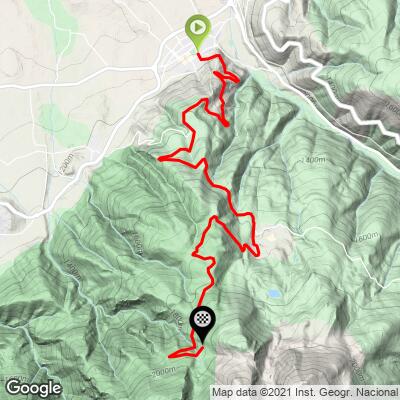
Coma Oriola climbs 11.2 km (7.0 mi) from Alp at 1163 m (3817 ft) to 1939 m (6363 ft), gaining 779 m (2556 ft) at an average of 6.9%.
By kilometer: 7.1%, 7.7%, 6.7%, 7.5% and 7.0% on the way out of Alp, an easier 4.9% at km 6, then 6.8%, 8.0%, 7.0%, 7.0% and 7.9% on the Coma Oriola road before the last 0.2 km flattens into the car park.
The steepest 500 m averages 10.7%, the steepest kilometer 9.2%, the steepest 2 km 8.1%, the steepest 5 km 7.4% and the steepest 10 km 7.2%.
Roadway: Asphalt from Alp to the car park, in decent shape for most of the climb, with painted edge lines, but the final couple of kilometers to Coma Oriola are cracked and patched - fine on road tires, just bumpy. This is ski-area access at close to 2000 m, so expect snow and ice in winter and plan to ride it from late spring to autumn.
Traffic: The GI-400 carries the local traffic between Alp, Das and La Molina, so the first half sees the most cars, especially on winter weekends. Once you turn off for Coma Oriola the road only goes to the ski area, and outside the ski season it's quiet.
Parking: Park in Alp near the start - the village has parking and services and is the usual base for both Masella and La Molina. If you'd rather start from the top, the Coma Oriola car park at the finish is large.
Gear: Nothing here calls for special gearing; a compact and a mid-range cassette do the job. The grade barely changes, so the job is finding one rhythm and holding it. The top is close to 2000 m and can be cool and windy even in summer - take a vest or jacket for the descent.
Provisions: Stock up in Alp, which has shops, cafes and restaurants. There's nothing on the road itself, and the services at Coma Oriola are built around the ski season, so don't rely on them in summer.
Before heading out on any cycling adventure check out our Things to Bring on a Cycling Trip and use our interactive check list to ensure you don't forget anything.
Alp is the natural base for this climb and the others that start around it: Super Molina, the Collada de Toses and the Coll de la Creueta from Das all leave from within a few kilometers. Puigcerdà, the main town of the Cerdanya and right on the French border, is a short drive away and has the widest choice of hotels and restaurants.
Across the border, our Cime de Coma Morera pages cover the climbs above Osséja. If you're traveling with people who aren't riding, Masella runs Segway routes in summer and has a picnic area in the pines at Escobairó. Check our Weather tool before heading up - the finish is close to 2000 m and conditions change quickly.
ROUTE MAP
MEMBER RATING
CURRENT WEATHER
PJAMM TRIPS ADVENTURE STARTER BUNDLES
Check out PJAMM Adventure's prepackaged (self-guided) cycling trips. They will help you plan, document and conquer your next adventure.
NEARBY CLIMBS (0) RADIAL PROXIMITY
FROM No Climbs Found
MEMBER REVIEWS & COMMENTS
Let us know what you thought of this climb. Signup for our FREE membership to write a review or post a comment.
Already have an account?
LOG IN HERE
