
19.4
PDI
6.4 mi
DISTANCE
2,714 ft
GAINED
7.9 %
AVG. GRADE
FULL CLIMB STATS
INTRO
PLAN YOUR ROUTE
 We've partnered with Sherpa-Map.com to bring you the best route planning tool. With a PRO Membership you can use this climb as a reference when creating your route.
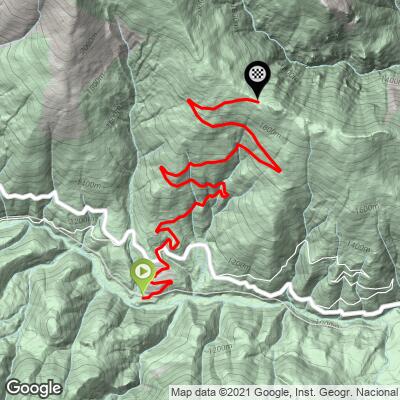
Collet de les Barraques averages 7.9% over 10.3 km (6.4 mi), gaining 827 m (2714 ft) from 1087 m (3566 ft) to 1893 m (6210 ft).
The first 2 km are the easiest, at 6.0% and 6.9%. From km 3 to the top every kilometer falls between 7.4% and 8.9%, with the hardest pair at km 3 and 4 (8.7% and 8.9%) and a long run of 8.1-8.4% kilometers through the middle of the climb. There is no real recovery anywhere after the first 2 km.
The steepest 500 m averages 12.6%, the steepest kilometer 10.5%, the steepest 2 km 9.6% and the steepest 5 km 8.8%.
Roadway: Paved all the way to the col on a narrow asphalt mountain road, in generally good condition with occasional potholes. The road is a dead end for road bikes: beyond the col the north side is a forest track and then a dirt road toward the hamlet of Vilamanya, so plan to descend the way you came up.
Traffic: Very light - riders describe the climb as almost traffic-free. Most of the cars you will meet belong to hikers heading for the Puigmal trailhead at the top, so expect a few more on summer weekends.
Parking: The climb starts right at Planoles on the N-260, so park in the village near the turnoff. At the top, there is a flat parking area just above the Corral Blanc refuge, used by hikers starting the Puigmal route, if you want to drive up and ride the climb as a descent first.
Provisions: There are no services on the climb. Planoles is a small village, so fill bottles and pick up food before you start; Ribes de Freser, the main town of the valley a short ride down the N-260, is the most reliable place to stock up. The Corral Blanc refuge near the top has a picnic area, but don't count on it for water.
Gear: Gear for a sustained 8-9% effort - the grade barely changes after km 2. The col sits close to 1900 m (6234 ft) and the whole climb is above 1000 m (3281 ft), so bring a layer for the descent even in summer.
Before heading out on any cycling adventure check out our Things to Bring on a Cycling Trip and use our interactive check list to ensure you don't forget anything.
Planoles sits on the left bank of the Rigard at about 1136 m (3727 ft) and is the smallest municipality in the Vall de Ribes, with around 300 residents. Its Romanesque church of Sant Vicenç, which keeps a 12th-century baptismal font, is worth a look before you set off, and the hamlet of Planès above the village has its own small Romanesque church of Sant Marcel. Planoles also has a stop on the Rodalies R3 line between Barcelona and Puigcerdà, so you can reach the start by train with your bike.
If you have a rest day, the col is the starting point of the classic hike to the Puigmal: about 19 km (11.8 mi) round trip with roughly 1160 m (3806 ft) of climbing, via the Puig de Dòrria, with the remains of an old chairlift from the French-side Err-Puigmal ski station near the summit. Down the valley in Ribes de Freser, the Cremallera rack railway climbs to the sanctuary in the Vall de Núria.
Several more climbs start within a few kilometers of Planoles, including the Collada de Toses and the roads up to the Coll de la Creueta - see other climbs nearby, or build a custom route from here, with our Routes in the Area tool.
ROUTE MAP
MEMBER RATING
CURRENT WEATHER
PJAMM TRIPS ADVENTURE STARTER BUNDLES
Check out PJAMM Adventure's prepackaged (self-guided) cycling trips. They will help you plan, document and conquer your next adventure.
NEARBY CLIMBS (0) RADIAL PROXIMITY
FROM No Climbs Found
MEMBER REVIEWS & COMMENTS
Let us know what you thought of this climb. Signup for our FREE membership to write a review or post a comment.
Already have an account?
LOG IN HERE
