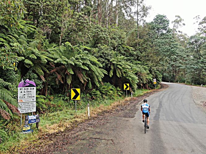
![Cycling Mt. Baw Baw, Victoria, Australia PJAMM Cyclist rides on roadway past Tour down Under sign for Mt. Baw Baw]()
Cycling Mt. Baw Baw, Victoria, Australia
Ride 12.3 kilometers gaining 960 meters at 7.8% average grade.
See also our Australia Top Bike Climbs page.
Mt. Baw Baw is the hardest bike climb in Australia. The first 5.5 kilometers are a warm up at 4% average grade, while the next 6.2 km average 11.5%, before dropping down to 4% for the final 600 meters to the finish at the Mt. Baw Baw Alpine Resort.
![Cycling Mt. Baw Baw, Victoria, Australia photo collage shows Tour down Under sign for Mt. Baw Baw; bike parked next to sign for Tanjil River East Beach; aerial drone photo shows how densely forested the entire climb is]()
We are surrounded by heavy forest the entire climb.
The name Baw Baw derives from the Woiwurrung (Aboriginal Australian) language and may mean echo or ghost.
![Cycling Mt. Baw Baw, Victoria, Australia aerial drone photos show climb start over the Tanjil River]()
Climb begins at the bridge over the Tanjil River.
Climb summary by PJAMM’s Brad Butterfield:
Mt. Baw Baw is one of the most remote climbs I have done in Australia and certainly one of the toughest as well. If accessing from the east, you’ll be on a decent quality gravel road for dozens of kilometers before reaching the Mt. Baw Baw turn off. From the West, the route of the climb, the road winds for mile upon mile without passing so much as a small house until you reach Warburton. I drove in from the East on the gravel road and parked the car on the highway before Mt. Baw Baw Ski Resort access road, to avoid paying a park entrance fee for the car. There weren’t any other “pedal” cyclists on the day I rode, but more than fifty motorcyclists passed me while I was riding. This is clearly the known joy ride spot for the local biker clubs. They often swung wide on the corners, so I’d take the descent easy. There were only a few cars and it seems the motorcyclists assume they will be the only ones on the road. The climb itself begins at a small creek with single digit grades. As you curve through thick foliage for a few kilometers, the gradient begins to bite a bit more. Then, Bam. You are hit with a wall, with still a little over 6 kilometers of climbing to go. Don’t expect Baw Baw to relent; she won’t until you reach the summit ski village. The dense Australian trees block any views for the duration of the climb. It’s just you and the Baw Baw wall -- until you get to the summit, then, there’s a cafe with hot chocolate for your effort!
![Cycling Mt. Baw Baw, Victoria, Australia photo collage highlights the dense forestation and foliage throughout the entire climb; ferns, large bushes, trees, etc.]()
![Cycling Mt. Baw Baw, Victoria, Australia photo collage shows hairpin turn in densely forested road]()
![Cycling Mt. Baw Baw, Victoria, Australia sign for Mt. Baw Baw and Rawson (Walhalla)]()
This climb is located in Baw Baw National Park (established 1979; 13,530 hectare/33,400 acres). The National Park includes the land of the Gunaikurnai and Wurundjeri people. Baw Baw National Park accounts for much of the Baw Baw Plateau, and is great to visit year-round, whether you’re looking for a snowy getaway, spectacular wildflowers, geological formations, or so much more. For more information on Baw Baw National Park, visit Parks Victoria’s website.
![Cycling Mt. Baw Baw, Victoria, Australia signs for Baw Baw Ski Resort]()
7.2 kilometers up from the start.
Mt. Baw Baw has been the finish of the Baw Baw Classic from 2001 to 2020. The race has not been held since Covid (no race in 2021 or 2022).
![Cycling Mt. Baw Baw, Victoria, Australia entrance to Mt. Baw Baw ski resort]()
Climb ends at the Mt. Baw Baw Ski Resort.

 We've partnered with Sherpa-Map.com to bring you the best route planning tool. With a PRO Membership you can use this climb as a reference when creating your route.

