![Cycling Dead Horse Gap, New South Wales, Australia bike parked next to road sign reading "Long Steep Descent Next 8km"]()
Cycling Dead Horse Gap, New South Wales, Australia
Ride 17.6 kilometers gaining 1,103 meters at 5.8% average grade.
This climb is ranked as the Fifth most difficult climb in Australia. The climb averages 7.1% if the one kilometer of descent is removed. There is a full two kilometer segment beginning at kilometer 3.6 that averages 10.6%.
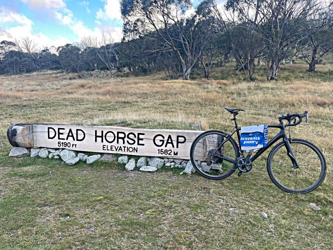
![Cycling Dead Horse Gap, New South Wales, Australia signs along the climb, include: Great Dividing Range Elevation 1580 m; Snowy Creek; Dead Horse Gap Elevation 1582 m; and Siberia]()
The Great Dividing Range is a series of mountain and hill ranges running 3,000 km. The east side of the range carries river flow to the Pacific Ocean and west side flows into the Murray-Darling Basin, and then to the Southern Ocean.
Climb summary by PJAMM Cycling’s Brad Butterfield.
Australia just keeps blowing me away. Each climb area has been so unique from the others. This climb, situated deep in the Kosciuszko National Forest (17AUD/per day entry fee), begins at the Snowy Creek campground.
![Cycling Dead Horse Gap, New South Wales, Australia Entrance to Kosciuszko National Park]()
Photo right - start of the climb.
You’ll be many kilometers from any towns at the start and throughout the climb, so plan accordingly for this very tough ride. Infrequent descending traffic brings in a thick smell of brake pads overheating, a great sign of a tough climb ahead for any serious climber. But, the traffic will almost certainly be very mild out that way, and all very respectful when passing. Be on the lookout for wildlife! I saw a massive buck when I was gearing up for my climb. The average gradient is a bit deceiving as there are a couple significant downhills en route to the summit. This is another ‘must do’ climb for Australia, but I’m starting to think that every climb in Australia is a MUST DO!
![Cycling Dead Horse Gap, New South Wales, Australia panoramic photo shows roadway snaking through valley filled with burned trees]()
Although the upper section of the climb is burned, most of the climb is pristine.
![Cycling Dead Horse Gap, New South Wales, Australia thick forestation covering the mountains]()
We are surrounded by and frequently covered by thick forest during the climb.
![Cycling Dead Horse Gap, New South Wales, Australia eucalyptus-lined roadway]()
![Cycling Dead Horse Gap, New South Wales, Australia bike parked next to roadsigns warning of "Long Steep Descent"]()
Photo left: Sign at the beginning of a 1 km 6% descent at km 6.3.
Photo right: Sign looking back the road just climbed at kilometer 15.1
![Cycling Dead Horse Gap, New South Wales, Australia aerial drone view of hairpins along the climb, road surrounded by dense forestation]()
Several real nice hairpins on the climb.
![Cycling Dead Horse Gap, New South Wales, Australia photo collage shows curves in roadway along the climb route]()
And when its not a hairpin, its a curve - this is a beautiful serpentine bike climb.
![Cycling Dead Horse Gap, New South Wales, Australia Leather Barrel Creek]()
Cross Leather Barrel Creek at the bottom of the km descent at kilometer 7.3.
![Cycling Dead Horse Gap, New South Wales, Australia bike parked against tree stump in grass surrounded by tall trees, rays of sunlight shine down through clouds onto bike]()
There were some stunning views and sights on this climb.
![Cycling Dead Horse Gap, New South Wales, Australia photo collage shows views along the climb, including tall eucalyptus trees, signs reading "Steep Descent" and warning of windy road the next 55 km.]()
![Cycling Dead Horse Gap, New South Wales, Australia aerial drone view shows PJAMM Cyclist standing next to sign for Dead Horse Gap, grassy area at climb finish]()
The finish of another extraordinary Australian bike climb.
![Cycling Dead Horse Gap, New South Wales, Australia aerial drone view shows PJAMM Cyclist riding on eucalyptus-lined roadway next to sign for Great Dividing Range]()

 We've partnered with Sherpa-Map.com to bring you the best route planning tool. With a PRO Membership you can use this climb as a reference when creating your route.

