
16.4
PDI
12.4 mi
DISTANCE
3,302 ft
GAINED
4.6 %
AVG. GRADE
FULL CLIMB STATS
INTRO
The usual way up to Sant Joan de l'Erm goes through Turbiàs. This version leaves that road to the skiers and takes the back lane through Albet instead - a string of small hamlets with Romanesque churches, hay meadows and very few cars - before joining the main road at Sant Andreu for the last climb to the nordic ski area at 1728 m.
From Castellbò it's 20 km (12.4 mi) with 1006 m (3302 ft) of climbing at an average of 4.6%. The first 7 km climb steadily at 4 to 8% up to Albet. Then the road wanders almost level for 6 km through Seix, Santa Creu and Sant Andreu, with a short dip along the way, and the last 7 km pick up again at 6 to 8% through the pines. The steepest kilometer is 8.1%, so this is about rhythm and time in the saddle rather than gears.
The road ends at the Basseta esplanade, where the refuge has a bar and serves food, and a big picnic area sits at the foot of the ski trails. In winter there are about 40 km of cross-country ski trails up here; in summer it's a quiet clearing in the Scots and mountain pine.
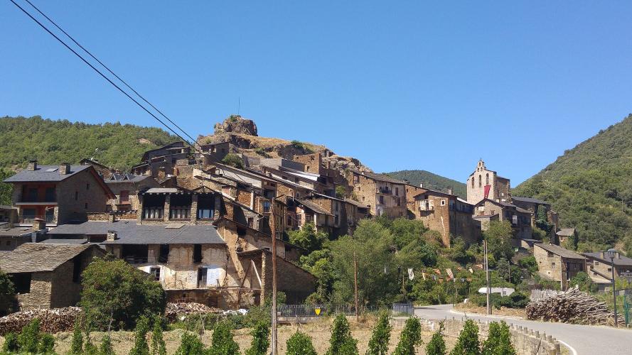
Give Castellbò a few minutes before you leave. The village climbs a steep spur below the site of the viscounts' castle, and its Gothic church of Santa Maria is right by the start. Viscount Arnau de Castellbò sheltered Cathars here in the early 1200s and fought against Simon de Montfort's crusade - the Church never forgave him, and in 1269, more than 40 years after his death, a church ruling ordered his remains dug up.
PLAN YOUR ROUTE
 We've partnered with Sherpa-Map.com to bring you the best route planning tool. With a PRO Membership you can use this climb as a reference when creating your route.
The climb is 20 km (12.4 mi) from 820 m (2692 ft) in Castellbò to 1728 m (5668 ft) at Sant Joan de l'Erm, gaining 1006 m (3302 ft) at an average of 4.6%. The steepest kilometer averages 8.1% and the steepest 500 m 9.2%.
Km 0-7, Castellbò to Albet: a steady 4 to 8% up the narrow valley road, with the steepest full kilometer of the climb around Albet.
Km 7-13, Albet to Sant Andreu: close to flat - 0 to 3% through Seix and Santa Creu, with a short descent before Sant Andreu. A good place to eat something.
Km 13-20, Sant Andreu to Sant Joan de l'Erm: the climbing comes back at a steady 5 to 8% through the pine forest, with the steepest 500 m around km 17 and an easier last kilometer onto the Basseta esplanade.
Roadway: Asphalt from bottom to top. The Carretera de Castellbò a Albet is a narrow lane with painted edge lines, winding up through woods with guardrails on the drops. Between Albet and Sant Andreu the road through Seix and Santa Creu is narrower still and patched in places. From Sant Andreu the road to Sant Joan de l'Erm is wider and smoother, since it carries the ski-area traffic. This is a nordic ski area, so expect snow and ice on the upper road in winter and early spring.
Traffic: Very light below Sant Andreu - a few residents and farm vehicles. From Sant Andreu up you share the road with everyone driving to Sant Joan de l'Erm, which means more cars on ski days and summer weekends, and campervans parked at the top.
Parking: Castellbò is a small, steep village, so park considerately near the church of Santa Maria at the start or along the road below the village, leaving room for residents. At the top, the Basseta esplanade at Sant Joan de l'Erm has plenty of parking if someone is meeting you there.
Gear: A compact with a 28 or 30 at the back covers it - nothing here is steeper than about 9%. It's a long climb, though, and the finish at 1728 m is a lot cooler than the Segre valley, so carry a jacket for the 20 km run back down.
Provisions: Castellbò and La Seu d'Urgell are the places to stock up; there's nothing to buy in Albet, Seix or Santa Creu. At the top, the Basseta refuge has a bar and serves food - check its hours outside the ski season - and the picnic area next to it has a fountain for the ride down.
Before heading out on any cycling adventure check out our Things to Bring on a Cycling Trip and use our interactive check list to ensure you don't forget anything.
La Seu d'Urgell is the place to stay: plenty of hotels and restaurants, the cathedral of Santa Maria in the old town, and the Parc del Segre, the whitewater course built for the 1992 Olympics, on the edge of town. Andorra is a short drive up the valley.
On the climb itself, the little Romanesque churches of Albet and Sant Andreu are right beside the road and make easy stops on the flat middle section. If you have time at the top, the waymarked forest walk from the Basseta refuge passes the ruins of the old sanctuary of Sant Joan de l'Erm, burned in 1936. Local tradition says Arnau de Castellbò brought the Holy Grail there from Béziers in 1208.
Our Castellbò - Sant Joan de l'Erm page covers the main road through Turbiàs. The two routes split between Castellbò and Sant Andreu and share the last 7 km, so ride up one and down the other. Port Ainé sits just over the ridge to the west, with its own paved climb from Rialp, and Routes in the Area will show you the rest of the Alt Urgell climbs within reach of Castellbò.
ROUTE MAP

MEMBER RATING
CURRENT WEATHER
PJAMM TRIPS ADVENTURE STARTER BUNDLES
Check out PJAMM Adventure's prepackaged (self-guided) cycling trips. They will help you plan, document and conquer your next adventure.
NEARBY CLIMBS (0) RADIAL PROXIMITY
FROM No Climbs Found
MEMBER REVIEWS & COMMENTS
Let us know what you thought of this climb. Signup for our FREE membership to write a review or post a comment.
Already have an account?
LOG IN HERE
