
22.8
PDI
8.3 mi
DISTANCE
3,367 ft
GAINED
7.7 %
AVG. GRADE
FULL CLIMB STATS
Page Contributor(s): Ard Oostra, Montreux, Switzerland
INTRO
Plan de Châtel climbs 13.3 km (8.3 mi) from Vernex, in the heart of Montreux, gaining 1026 m (3,367 ft) at an average grade of 7.7% to an alpine pasture at roughly 1470 m (4,823 ft) in the Vaud Prealps. In a little over an hour of riding you go from palm trees and the Lake Geneva waterfront to cowbells and open grazing land.
The route strings together a series of classic Montreux hill villages. It climbs out of town to Chamby, the upper terminus of the Blonay-Chamby museum railway, then follows the aptly named Route des Narcisses to Les Avants, an old Belle Époque resort famous for the wild narcissus that carpet its meadows in late spring. From there it continues up to Sonloup, at the top of the 1912 Les Avants-Sonloup funicular, before leaving the villages behind on Route de la Cergniaule.
The last stretch is what makes this climb more than a scenic tour. After a brief breather along the floor of the Vallon d'Orgevaux, the final kilometer onto Plan de Châtel averages over 12% on a narrow alp road, with the steepest half-kilometer at 13.8% - a real sting at the end of an otherwise steady climb. It's one of several serious climbs from Montreux into the Prealps, alongside the harder Col du Jaman.
PLAN YOUR ROUTE
 We've partnered with Sherpa-Map.com to bring you the best route planning tool. With a PRO Membership you can use this climb as a reference when creating your route.
 From Vernex, Plan de Châtel climbs 13.3 km (8.3 mi) at a 7.7% average, gaining 1026 m (3,367 ft) from a start at 453 m (1,486 ft).
The climb opens firmly, with the first 2 km (1.2 mi) out of Montreux at around 8%, before settling into a steady 6-7% through Chamby and along Route des Narcisses to Les Avants. The grade builds again above Les Avants: the stretch up to Sonloup and on along Route de la Cergniaule holds 9-10% for about 2 km (1.2 mi), the steepest sustained climbing before the finish.
Around km 11 the road eases to under 4% along the floor of the Vallon d'Orgevaux - use it, because the final 1.3 km (0.8 mi) up to Plan de Châtel average about 12%, with the steepest kilometer at 12.8% and the steepest half-kilometer at 13.8%. The steepest mile of the climb averages 10.8%, and the steepest 5 km (3.1 mi) average 8.7%.
Roadway: Paved local roads through Montreux, Chamby, Les Avants and Sonloup, with plenty of hairpins in the lower half. Above Sonloup, Route de la Cergniaule narrows, and the final section on Route de Plan-de-Châtel is a single-lane alp road serving the pastures rather than a through route. In winter the Sonloup-Cergniaulaz section is closed to traffic and used as a sledge run, so this is a summer-season climb above Sonloup.
Traffic: Expect town traffic for the first couple of kilometers out of Montreux, then lighter local traffic through Chamby and Les Avants. Above Sonloup, cars are mostly limited to visitors heading for the Auberge La Cergniaulaz and hikers driving to the trailhead in the Vallon d'Orgevaux.
Parking: Parking in central Montreux is mostly paid, so many riders start from their hotel or ride in along the lakefront. To ride just the upper half, Les Avants and Sonloup are both reachable by train and funicular, and there's a large hikers' car park at the head of the Vallon d'Orgevaux, just below the final ramp, which is the usual starting point for the walk up to Plan de Châtel and Le Molard.
Most of this climb is comfortable on a compact crankset, but the final kilometer at over 12% is steep enough that a 30-32t low gear is well worth having, especially on tired legs after 12 km (7.5 mi) of climbing.
Montreux has everything you need before you start. Higher up, the Auberge La Cergniaulaz, a large wooden chalet restaurant at about 1300 m (4,265 ft) right on the route, is open in both summer and winter and makes a good stop before or after the final ramp. The top is open pasture with no services, and it's noticeably cooler than the lakeshore, so bring a layer for the descent back to Montreux.
Before heading out on any cycling adventure check out our Things to Bring on a Cycling Trip and use our interactive check list to ensure you don't forget anything.
Les Avants has a bigger history than its size suggests. It grew up as a 19th-century winter resort around the Grand Hôtel des Avants (now the Le Châtelard international school), hosted the first European Ice Hockey Championship in 1910, and drew visitors like Ernest Hemingway, who stayed here in the 1920s and recalled it in A Moveable Feast, and Noël Coward, who kept a chalet in the village for more than a decade. In late spring, the meadows along Route des Narcisses turn white with wild narcissus.
If you'd rather not ride back down, the MOB railway from Les Avants and the funicular from Sonloup make it easy to shuttle part of the route, which also makes this a good climb for mixed-ability groups. For more climbs from Montreux into the Prealps, see our Routes in the Area tool.
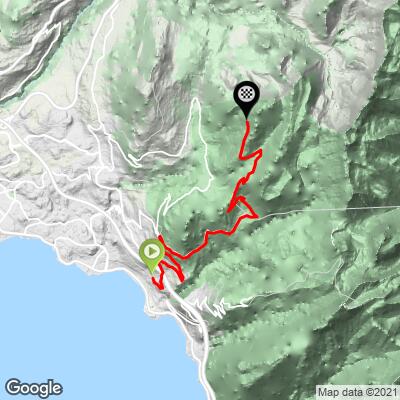
ROUTE MAP
MEMBER RATING
CURRENT WEATHER
PJAMM TRIPS ADVENTURE STARTER BUNDLES
Check out PJAMM Adventure's prepackaged (self-guided) cycling trips. They will help you plan, document and conquer your next adventure.
NEARBY CLIMBS (0) RADIAL PROXIMITY
FROM No Climbs Found
MEMBER REVIEWS & COMMENTS
Let us know what you thought of this climb. Signup for our FREE membership to write a review or post a comment.
Already have an account?
LOG IN HERE
