
44.5
PDI
38 mi
DISTANCE
7,363 ft
GAINED
3.2 %
AVG. GRADE
FULL CLIMB STATS
Page Contributor(s): Ties Arts, Netherlands
INTRO
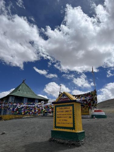
Tanglang La is one of the signature climbs of India's Leh-Manali Highway (NH3): 38 miles and 7,363 ft of gain from the Indus Valley town of Upshi, through the Ladakhi villages of Miru, Gya, and Rumtse, to a summit around 17,470 ft (5,325 m) - among the highest paved roads on Earth.
The modest 3.2% average grade undersells the real difficulty, which is altitude. Riders spend the entire day above 11,000 ft, with the final miles topping 16,000-17,000 ft, where the air holds roughly half the oxygen of sea level.
The terrain is stark, wide-open high-desert Ladakh, with prayer flags marking the summit and views across bare mountain ranges in every direction.
Tanglang La has long been billed as one of the world's highest motorable passes, though Ladakh has since built several roads even higher (Umling La, Khardung La), so treat "highest" claims loosely.
The Border Roads Organisation (BRO) maintains NH3 as a strategic route and has paved most of this ascent in recent years - a real change from the rough, broken gravel older trip reports describe. It's open only roughly late May/June through mid-October; the rest of the year it's buried in snow. Notably, BRO is currently boring a 12-15 km tunnel beneath the pass (about 65% complete as of mid-2026) that will eventually bypass Tanglang La's exposed summit once finished around late 2027, which could either mean less traffic at the top, or no more cycling.
PLAN YOUR ROUTE
 We've partnered with Sherpa-Map.com to bring you the best route planning tool. With a PRO Membership you can use this climb as a reference when creating your route.
 The 3.2% average hides real variation. The opening quarter-mile out of Upshi kicks up to 11.5%, and the single steepest 100 yards on the route touches nearly 19%. After that, the grade settles into a long, rolling grind up the Indus Valley through Miru, Gya, and Rumtse before the final push to the pass.
See our Interactive Profile Tool for the full gradient breakdown by segment.
See our Interactive Profile Tool for the full gradient breakdown by segment.
Roadway: Paved for nearly the entire climb. The Border Roads Organisation (BRO) has resurfaced most of this stretch of NH3 in recent years, and current trip reports describe smooth tarmac over the pass itself. Older accounts (pre-2020s) described broken, unpaved sections nearer the summit; conditions can still include patchy repairs, gravel shoulders, or minor rockfall ("shooting stones") after winter, so don't expect flawless pavement the whole way.
Traffic: NH3 is a strategic Indian Army supply route as well as a tourist highway, so expect military convoys and trucks alongside motorcycle tourists and the occasional other cyclist, especially in the peak July-September season. Traffic is moderate rather than heavy, but the road is narrow with real drop-offs in places, so give trucks and convoys plenty of room.
Parking: There's no formal trailhead. Riders typically stage from Upshi, the last real town before the long climb, or from Leh itself, roughly 30 miles/50 km further down the valley. Support vehicles can be arranged through any Leh-based tour operator; there's no dedicated parking beyond roadside pullouts near the summit's prayer-flag viewpoint.
This is a high-altitude climb above all else - the entire route sits above 11,000 ft, and the final miles top 16,000-17,000 ft, where altitude sickness is a real risk regardless of fitness. Acclimatize in Leh (about 11,500 ft) for at least 2-3 days before attempting this climb, and know the symptoms of AMS.
Weather swings hard and fast at this elevation - pack windproof and insulating layers even in July and August, since wind chill at the summit can drop temperatures well below what the valley floor suggests.
Sun exposure is intense at altitude too.
There's little food or water available on the mountain itself beyond the small villages of Miru, Gya, and Rumtse, so carry more than you think you'll need and fuel up in Upshi or Leh beforehand.
Before heading out on any cycling adventure check out our Things to Bring on a Cycling Trip and use our interactive check list to ensure you don't forget anything.
The nearest airport is Leh (Kushok Bakula Rimpochee Airport, IXL), about 30 miles/50 km from the base of the climb at Upshi - most riders fly into Leh and spend several days acclimatizing before attempting a pass this high.
The road is open only roughly late May/June through mid-October and is snowbound the rest of the year. Even within that window, July-August is the most stable weather, while May-June and September-October can bring cold winds and icy road edges - check current BRO/highway status before you go, since opening dates shift year to year with snowpack.
Worth knowing for anyone planning ahead: BRO is currently boring a large tunnel beneath Tanglang La (reported around 65% complete as of mid-2026) that will eventually bypass the pass's exposed summit stretch once finished. Riding over the actual pass, rather than through a future tunnel, is still the current experience - but that's expected to change in the coming years.
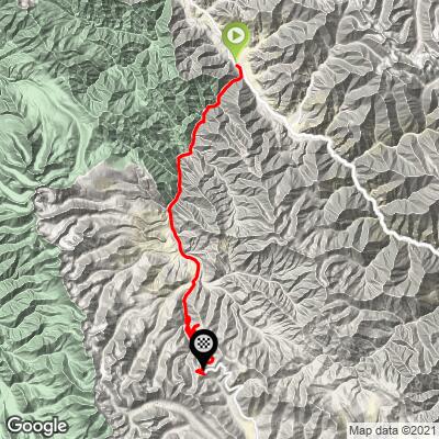
ROUTE MAP
MEMBER RATING
CURRENT WEATHER
PJAMM TRIPS ADVENTURE STARTER BUNDLES
Check out PJAMM Adventure's prepackaged (self-guided) cycling trips. They will help you plan, document and conquer your next adventure.
NEARBY CLIMBS (0) RADIAL PROXIMITY
FROM No Climbs Found
MEMBER REVIEWS & COMMENTS
Let us know what you thought of this climb. Signup for our FREE membership to write a review or post a comment.
Already have an account?
LOG IN HERE
