
17.5
PDI
8.4 mi
DISTANCE
2,912 ft
GAINED
6.3 %
AVG. GRADE
FULL CLIMB STATS
INTRO
Ogassa + Coll de Jou climbs 13.5 km (8.4 mi) from Sant Joan de les Abadesses, in the Ripollès, through the old mining village of Ogassa to the Coll de Jou at 1637 m (5371 ft) - the pass between the Taga and the Puig de Sant Amand that links the Ter valley with the Vall de Ribes. It gains 888 m (2912 ft) at a 6.3% average and ranks #89 in Spain and #1287 in the world in our database.
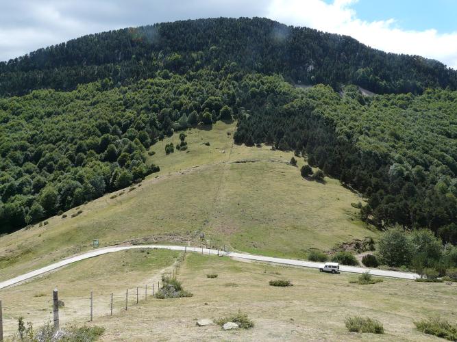
It's really two hard climbs joined by a breather. The first 4.0 km (2.5 mi) up the valley to Ogassa are gentle, but above the village the road turns into a narrow lane and climbs 3.0 km (1.9 mi) at 10.3%, with ramps over 14%. A rolling 3.6 km (2.2 mi) past the Romanesque church of Sant Martí d'Ogassa gives you time to recover, before a final 2.9 km (1.8 mi) at 10.0% on concrete to the col. It's a rarely used road, and the reward at the top is a wide view east over the ridges of the eastern Pyrenees, with the Taga and the Puigmal close by.
Ogassa's hillsides were mined for coal from the late 18th century until 1967, and it was this coal that brought the railway to the Ripollès in 1880. Over the col, the road continues down through Bruguera to Ribes de Freser.
PLAN YOUR ROUTE
 We've partnered with Sherpa-Map.com to bring you the best route planning tool. With a PRO Membership you can use this climb as a reference when creating your route.
Ogassa + Coll de Jou is 13.5 km (8.4 mi) long and gains 888 m (2912 ft) at a 6.3% average, from 776 m (2546 ft) in Sant Joan de les Abadesses to about 1631 m (5351 ft) at the Coll de Jou.
The climb has four parts. The first 4.0 km (2.5 mi) to Ogassa average just 3.9%. Then comes the first steep section: 3.0 km (1.9 mi) at 10.3%. The next 3.6 km (2.2 mi), past Sant Martí d'Ogassa, average only 2.7% and include a short descent. The final 2.9 km (1.8 mi) to the col average 10.0%.
The steepest 0.5 km averages 14.3%, the steepest kilometer 12.4% and the steepest 2 km 11.4%. The steepest 5 km average 8.2% - well above the overall average, because the two flatter sections pull it down.
Roadway: The lower climb on the GIV-5211 to Ogassa is asphalt. Higher up, the Camí d'Ogassa a Coll de Jou is a narrow lane that turns to concrete, and the concrete is in poor, bumpy condition in places between roughly 1300 and 1500 m (4265 and 4921 ft), where freeze-thaw cycles take their toll. Take the descent carefully, and if you continue over the col toward Bruguera and Ribes de Freser, expect more concrete and descents steeper than 15% in places.
Traffic: Traffic is light. The road above Ogassa is rarely used beyond local farm traffic and walkers driving up for the Taga. Cattle and sheep farming is still a mainstay in Ogassa, so expect the occasional herd or farm vehicle.
Parking: Sant Joan de les Abadesses is a town of about 3500 people, so park in town and roll to the start at the junction with the GIV-5211 on its western edge. There's also parking at the Coll de Jou itself, a popular starting point for the walk up the Taga.
Gear: Two separate 3 km (1.9 mi) sections at 10% with ramps beyond 14% call for low gearing - a compact with a 30- to 34-tooth cog is the sensible choice. Use the flatter middle section to recover, and save something for the concrete finish. At over 1600 m (5249 ft), the col can be much cooler and windier than the valley, so bring a wind layer.
Provisions: Sant Joan de les Abadesses is your last place for shops and cafes. Ogassa is known for its springs, including the Font Gran along the route through the village, but carry enough water for the whole climb - there are no services above Ogassa.
Before heading out on any cycling adventure check out our Things to Bring on a Cycling Trip and use our interactive check list to ensure you don't forget anything.
Sant Joan de les Abadesses grew up around its monastery, founded in 887 by Wifred the Hairy as one of Catalonia's first convents, with his daughter Emma as its first abbess. The monastery church, consecrated in 1150, is a highlight of Catalan Romanesque, and the 15th-century Palau de l'Abadia now houses the tourist office. The planned 13th-century Vila Vella keeps its original street plan, an arcaded Plaça Major and remains of the walls, and the Pont Vell, a Gothic bridge over the Ter destroyed in the Civil War, has since been rebuilt.
Ogassa's mining past is everywhere once you know to look: the miners built the Capella de Santa Bàrbara in 1881-1882, and the old railway bed that carried the coal now forms the Ruta del Ferro i del Carbó greenway. The village's Romanesque churches, Sant Martí d'Ogassa among them, date from the 11th century.
At the col, the Taga (2035 m / 6677 ft) is about an hour's walk away. See other climbs nearby, or build a custom route from here, with our Routes in the Area tool.
ROUTE MAP

MEMBER RATING
CURRENT WEATHER
PJAMM TRIPS ADVENTURE STARTER BUNDLES
Check out PJAMM Adventure's prepackaged (self-guided) cycling trips. They will help you plan, document and conquer your next adventure.
NEARBY CLIMBS (0) RADIAL PROXIMITY
FROM No Climbs Found
MEMBER REVIEWS & COMMENTS
Let us know what you thought of this climb. Signup for our FREE membership to write a review or post a comment.
Already have an account?
LOG IN HERE
