
16.6
PDI
12.4 mi
DISTANCE
3,263 ft
GAINED
4.7 %
AVG. GRADE
FULL CLIMB STATS
INTRO
PLAN YOUR ROUTE
 We've partnered with Sherpa-Map.com to bring you the best route planning tool. With a PRO Membership you can use this climb as a reference when creating your route.
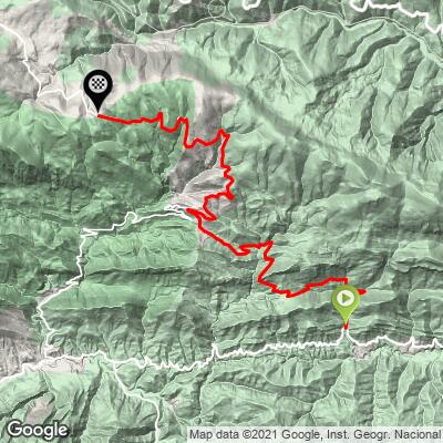
Coll de la Creueta via Gombrèn climbs 20.0 km (12.4 mi) from 977 m (3206 ft) to 1918 m (6294 ft), with 995 m (3263 ft) of total climbing and about 53 m (175 ft) of descent along the way, for an average of 4.7%.
By kilometer: 6.8%, 5.9%, 6.8%, 5.9% and 3.3% to the saddle, then -0.8% and -3.4% downhill. Back on the climb: 5.8%, 5.8% and 6.8% to Castellar de n'Hug, then 4.4%, 6.0%, 8.1%, 4.3%, 7.8%, 6.5%, 5.8%, 3.1%, 4.3% and 1.1% to the pass.
The steepest 500 m averages 8.9%, the steepest kilometer 8.1%, the steepest 2 km 7.4%, the steepest 5 km 6.7% and the steepest 10 km 6.1%.
Roadway: Paved throughout. The local road from the GI-402 to Castellar de n'Hug is in good shape, and the BV-4031 above Castellar is a well-surfaced mountain road with a painted center line. The pass is at 1918 m, so snow and ice are possible from late autumn to spring - if you're riding in spring or autumn, look at the Servei Català de Trànsit road information first.
Traffic: Light on the first 10 km, which carry little more than local traffic. Above Castellar you share the BV-4031 with visitors heading for the village and the Llobregat springs, so expect more cars on weekends and holidays.
Parking: Gombrèn, a couple of kilometers before the start, is the easy place to park. Coming by train, get off at Campdevànol on the R3 line and ride the GI-401 up to Gombrèn as a warm-up.
Gear: A standard compact is enough - nothing here stays much above 8% for long. The length and altitude are the challenge: 20 km and close to 1000 m of climbing take time, and the last few kilometers are exposed. Pack a jacket for the descent from 1918 m.
Provisions: Fill bottles in Gombrèn or Campdevànol. Castellar de n'Hug, at about km 10, is the only place to stop on the way, with bars and restaurants; there's nothing at the pass.
Before heading out on any cycling adventure check out our Things to Bring on a Cycling Trip and use our interactive check list to ensure you don't forget anything.
Gombrèn is small, but there's plenty around it. The Montgrony sanctuary sits in the cliffs a short way from the start, with the stairs from the Count Arnau legend and, above them, the Romanesque church of Sant Pere from the late 11th century, which looks out toward the Pedraforca. Excavations between 1986 and 1995 uncovered Mataplana castle, abandoned since the early 1400s. The sanctuary road is a climb of its own - see our Carretera de Montgrony page.
For Castellar de n'Hug, the Fonts del Llobregat and the Gaudí gardens in La Pobla de Lillet, see our page for the Coll de la Creueta from La Pobla de Lillet, which shares the top 10 km with this route. Over the top, the road drops toward Toses and the Collada de Toses, so you can loop back to Ribes de Freser through the Vall de Ribes, where the Collet de les Barraques climbs from Planoles. Routes in the Area shows how the climbs around the Creueta link up.
ROUTE MAP
MEMBER RATING
CURRENT WEATHER
PJAMM TRIPS ADVENTURE STARTER BUNDLES
Check out PJAMM Adventure's prepackaged (self-guided) cycling trips. They will help you plan, document and conquer your next adventure.
NEARBY CLIMBS (0) RADIAL PROXIMITY
FROM No Climbs Found
MEMBER REVIEWS & COMMENTS
Let us know what you thought of this climb. Signup for our FREE membership to write a review or post a comment.
Already have an account?
LOG IN HERE
