
20.8
PDI
7.1 mi
DISTANCE
2,975 ft
GAINED
7.9 %
AVG. GRADE
FULL CLIMB STATS
INTRO
PLAN YOUR ROUTE
 We've partnered with Sherpa-Map.com to bring you the best route planning tool. With a PRO Membership you can use this climb as a reference when creating your route.
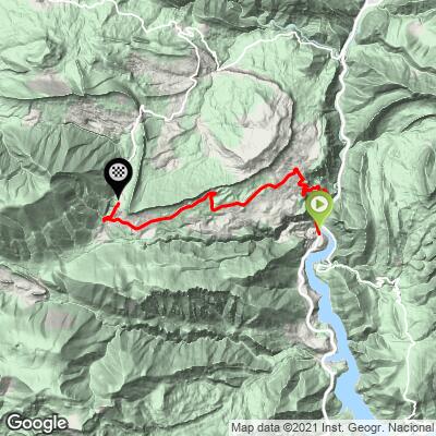
Coll de Fumanya (South) is 11.4 km (7.1 mi) long and gains 907 m (2,975 ft) at a 7.9% average, rising from 663 m (2,174 ft) at the Cercs power station to 1,568 m (5,143 ft) at the col.
Km 0-1: 6.9% - the gentlest kilometer until the very top.
Km 1-9: the heart of the climb - eight straight kilometers between 8.4% and 9.2%, with the 4-5 km stretch the toughest whole kilometer at 9.2%. There is almost no flat ground to recover on.
Km 9-11.4: easier - 7.8% for km 9-10, then about 5.0% for km 10-11 and a gentle finish at the col.
Steepest sections: 100 yd (91 m) at 11.9%; 0.5 km (0.3 mi) at 10.9%; 1 km (0.6 mi) at 10.0%; 1 mi (1.6 km) at 9.6%; 2 km (1.2 mi) at 9.4%; 5 km (3.1 mi) at 9.0%; 10 km (6.2 mi) at 8.5%.
Roadway: The BV-4025 is paved the whole way. It leaves the C-16 about 5 km (3.1 mi) south of Guardiola de Berguedà, passes the entrance to the Baells reservoir and the Cercs power plant, then climbs through the Sant Corneli colony toward Fígols and the col. The road is owned by the Diputació de Barcelona. At around 1,500 m (4,900 ft), expect ice and snow on winter mornings.
Traffic: Light overall. The heaviest traffic is on the first few kilometers, where the road serves Sant Corneli; above Fígols it thins to local cars and, in season, visitors to the dinosaur site.
Parking: The tourist board's road circuit starts at the church square in Guardiola de Berguedà; from there, add about 5 km (3.1 mi) along the C-16 to reach the BV-4025 turnoff.
Gear: This is a gearing climb - eight kilometers at 8.4% to 9.2% with no real flat. A compact crank with a 32- or 34-tooth cog makes it a rhythm ride instead of a grind. Bring a light layer for the descent, which is full of tight bends.
Provisions: Plan on carrying everything you need: the climb has no shops, and the only facilities are the museum in Sant Corneli and the dinosaur centre by the col, both on seasonal hours. Fill bottles in Guardiola or Cercs before you start.
Before heading out on any cycling adventure check out our Things to Bring on a Cycling Trip and use our interactive check list to ensure you don't forget anything.
The col is the place to spend time off the bike. Fígols, a short way along the road, has the Romanesque church of Santa Cecília (11th-12th century), and a 14 km (8.7 mi) walking route from the Cercs mining museum links the old mines, Fígols and the dinosaur tracks, with about 700 m (2,297 ft) of climbing over 4.5 hours - a good rest-day option. The cliffs of Vallcebre above the road have their own circular trail.
The tourist board's road circuit, the Volta al Pradell, La Trapa i el Collet, takes in Fumanya, Coll de Pradell and the Alt de Maçaners in about 3.5 hours, and drops through the Saldes valley with views of Pedraforca. Our Coll de Pradell and Coll de Peguera pages cover the neighboring climbs, and Berga is the larger town for lodging and services.
See other climbs nearby, or build a custom route from here, with our Routes in the Area tool.
ROUTE MAP
MEMBER RATING
CURRENT WEATHER
PJAMM TRIPS ADVENTURE STARTER BUNDLES
Check out PJAMM Adventure's prepackaged (self-guided) cycling trips. They will help you plan, document and conquer your next adventure.
NEARBY CLIMBS (0) RADIAL PROXIMITY
FROM No Climbs Found
MEMBER REVIEWS & COMMENTS
Let us know what you thought of this climb. Signup for our FREE membership to write a review or post a comment.
Already have an account?
LOG IN HERE
