

20.3
PDI
10.2 mi
DISTANCE
3,370 ft
GAINED
6.2 %
AVG. GRADE
FULL CLIMB STATS
Page Contributor(s): Lisa Irizarry and Matthew Jiang, New York, New York.
INTRO
Coll de Port climbs 16.4 km (10.2 mi) from Sant Llorenç de Morunys, in the Vall de Lord, over the pass and on to the Tuixent-La Vansa nordic ski station, gaining 1,027 m (3,370 ft) at a 6.2% average grade. It starts at 909 m (2,983 ft), crosses Coll de Port at about 1,672 m (5,486 ft) after roughly 13.4 km (8.3 mi), and finishes at 1,925 m (6,317 ft). It ranks #961 on our list of the world's hardest climbs.
The pass links the Vall de Lord with the remote Vall de la Vansa, between the Port del Comte massif and the Serra del Verd. It is a quiet, remote road in the Catalan pre-Pyrenees. Riders describe it as practically empty of traffic, with a viewpoint over the Berguedà valleys and the Pyrenees, and the steady gradient is slightly harder on this southern side. Do not confuse it with the Col de Port in France's Ariège.
Most riders stop at the pass, but the road keeps going. A spur of about 3 km (1.9 mi) climbs about 250 m (820 ft) at roughly 8% from the top of the pass to the Tuixent-La Vansa ski station, and it is worth riding if you want the full climb.
PLAN YOUR ROUTE
 We've partnered with Sherpa-Map.com to bring you the best route planning tool. With a PRO Membership you can use this climb as a reference when creating your route.
Coll de Port covers 16.4 km (10.2 mi) and 1,027 m (3,370 ft) at a 6.2% average, from 909 m (2,983 ft) to 1,925 m (6,317 ft). The steepest 0.5 km (0.3 mi) averages 9.9%, the steepest 1 km (0.6 mi) 9.1%, the steepest 2 km (1.2 mi) 8.6%, the steepest 5 km (3.1 mi) 7.5% and the steepest 10 km (6.2 mi) 6.8%.
It is a steady climb with no real wall. The first kilometer is 6.2%, followed by a gentler stretch that flattens to under 1% between 2 and 3 km (1.2 and 1.9 mi), and then the road settles into 6% to 7% for most of the way, with a brief 7.7% pitch around 5 to 6 km (3.1 to 3.7 mi). The grade builds again toward the end, running 7.5% and 8.7% between 13 and 15 km (8.1 and 9.3 mi), which includes the final spur to the ski station. Pace it evenly and you will have something left for the last 3 km (1.9 mi).
Roadway: The road is narrow and paved all the way, but the asphalt is worn and rough in places, which makes the climb harder than the numbers suggest. The 3 km (1.9 mi) spur from the pass to the ski station has the roughest surface, so expect patches near the top. About 4 km (2.5 mi) below the pass, a branch road leaves toward the Port del Comte ski area.
Traffic: Practically non-existent. The road only serves the villages of the Vansa valley and the ski station, so on most days you will have it to yourself.
Parking: Sant Llorenç de Morunys is a small medieval town at 925 m (3,035 ft), and it has a public car park beside the start of local routes.
Gear: A compact crankset or a 30 to 32 tooth rear cog keeps the 8% to 9% sections comfortable. Carry a spare tube and wear a windproof layer, because the temperature drops noticeably above 1,600 m (5,250 ft).
Provisions: Fill your bottles in Sant Llorenç de Morunys, a good place to rest and refill, because there is little on the climb itself.
Before heading out on any cycling adventure check out our Things to Bring on a Cycling Trip and use our interactive check list to ensure you don't forget anything.
Sant Llorenç de Morunys is a compact walled town with medieval walls with four surviving gateways and cobbled streets. Its 11th-century Romanesque church of Sant Llorenç, once part of a Benedictine monastery, has a 16th-century cloister and Gothic and Baroque altarpieces, and the Museu de la Vall de Lord next door covers fossils, tools and Stone Age finds. The Santuari de Lord, a hermitage site documented since the late 10th century with a guesthouse, sits in an exclave of the municipality, and the Llosa del Cavall reservoir is popular for kayaking and paddle surfing.
This climb is one of several roads out of the town. Our St. Llorenç - Antenes Ctra. Port del Comte page covers the climb toward the ski area, and Coll de Josa and Tuixent have pages of their own. To combine Coll de Port with the neighbouring passes in a long day, see our PJAMM loop Coll de Port + Coll de Josa + Pista Gosol - 156.2 km (97.1 mi) with 3,484 m (11,430 ft) of climbing.
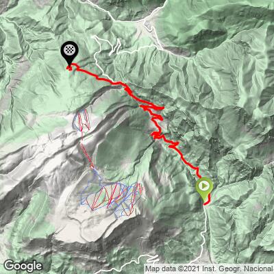
ROUTE MAP
MEMBER RATING
CURRENT WEATHER
PJAMM TRIPS ADVENTURE STARTER BUNDLES
Check out PJAMM Adventure's prepackaged (self-guided) cycling trips. They will help you plan, document and conquer your next adventure.
NEARBY CLIMBS (0) RADIAL PROXIMITY
FROM No Climbs Found
MEMBER REVIEWS & COMMENTS
Let us know what you thought of this climb. Signup for our FREE membership to write a review or post a comment.
Already have an account?
LOG IN HERE
