
27
PDI
11.4 mi
DISTANCE
4,241 ft
GAINED
6.7 %
AVG. GRADE
FULL CLIMB STATS
INTRO
Coll de Peguera climbs 12.7 km (7.9 mi) from the Llobregat valley at Cercs to 1674 m (5,491 ft), gaining 1011 m (3,316 ft) at a steady, unrelenting 8.0%. It's one of the most consistent hard climbs in the Berguedà: from km 1 to km 9, not a single kilometer drops below 8.4%.
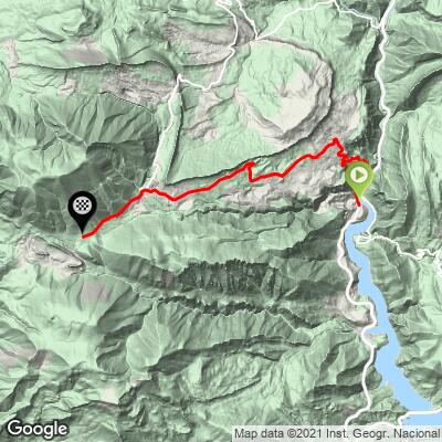
This is coal country. The opening hairpins climb to Sant Josep and Sant Corneli, the old colony at the heart of what was Catalonia's most important mining district, with the Baells reservoir and the Cercs power station dropping away below. Past the Fígols turnoff the road opens up beneath the great rock walls of Vallcebre, where the wind can make the steady 9% feel harder still.
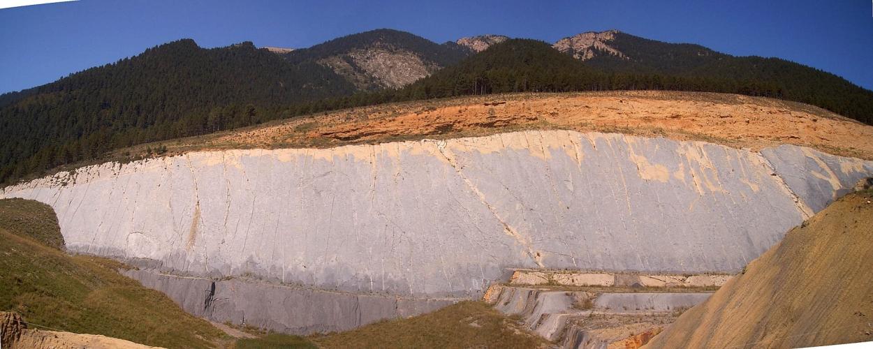
Near the Coll de Fumanya, around km 11, you pass one of Europe's most important dinosaur trackway sites: more than 3,500 footprints from the very end of the Cretaceous, about 66 million years old, preserved on a steep rock face that open-pit coal mining exposed. Beyond the coll the road narrows into forest and eases to the finish at the Pla de la Creu de Fumanya.
The valley's history is as dramatic as the geology. In January 1932 the miners of Fígols and Sant Corneli rose up and proclaimed libertarian communism during the Revolta de l'Alt Llobregat, a five-day uprising that ended when the army moved in. The mines themselves closed in the 1990s. Coll de Pradell starts from the same point at the power station and shares much of this road before branching off toward its infamous 15% final kilometer.
PLAN YOUR ROUTE
 We've partnered with Sherpa-Map.com to bring you the best route planning tool. With a PRO Membership you can use this climb as a reference when creating your route.
 Creu de Fumanya is 12.7 km (7.9 mi) long and gains 1011 m (3,316 ft) at an 8.0% average, from 663 m (2,174 ft) at the Cercs power station to 1674 m (5,491 ft) at the Pla de la Creu de Fumanya.
Km 0-1: 6.8% - the gentlest kilometer until the very top.
Km 1-9: the heart of the climb - eight straight kilometers between 8.4% and 9.2%, through the hairpins to Sant Corneli and up beneath the Vallcebre cliffs.
Km 9-12.7: easier - 7.7% for km 9-10, then 5.6-6.9% past the Coll de Fumanya (about 1566 m) and on through the forest to the finish.
Steepest sections: 100 yd (91 m) at 11.8%, 0.5 km at 10.9%, 1 km at 9.9%, 2 km at 9.4%, 5 km at 9.1% and 10 km at 8.5%.
Roadway: Paved the entire way. The lower road, the BV-4025, winds up through eight hairpins to Sant Josep and Sant Corneli before straightening out toward Fígols and Vallcebre. Above Fumanya, on the road toward Peguera, it becomes much narrower but stays well surfaced. The stretch beneath the Vallcebre walls is open and exposed, so wind is often the bigger factor than the pavement. The final ~1km to the ski resort is unpaved.
Traffic: Light. Expect local traffic to Sant Corneli, Fígols and Vallcebre and visitors heading to the Fumanya dinosaur site in season; beyond the Coll de Fumanya it's very quiet.
Parking: The climb starts beside the power station in the Llobregat valley, just off the C-16 north of Berga. For a support car, Sant Corneli (home to the Museu de les Mines de Cercs, a few kilometers up) and the Dinosaures Fumanya interpretation centre near the top both make easy meeting points.
Gear: Gearing is everything here - eight consecutive kilometers at 8.4-9.2% with no flat ground to recover. A compact with a 32- or 34-tooth cog lets you settle into a rhythm instead of grinding, and a wind vest earns its place for the exposed middle section and the descent.
Provisions: Stock up in Berga, Cercs or Guardiola de Berguedà beforehand - there are no shops on the climb. The mining museum at Sant Corneli and the dinosaur interpretation centre near the top are the only facilities along the way, and both keep seasonal hours.
Before heading out on any cycling adventure check out our Things to Bring on a Cycling Trip and use our interactive check list to ensure you don't forget anything.
This climb is a ride through the history of Catalan coal, and it's worth building in time off the bike. At Sant Corneli, the Museu de les Mines de Cercs tells the story of the colony and the Alt Llobregat coalfield, including visits into the old Sant Romà mine.
Higher up, the Dinosaures Fumanya interpretation centre explains the trackways with audiovisuals and interactive displays, and a boardwalk trail with a suspension bridge, La ruta del Cretaci, brings you close to the footprint wall. Opening is seasonal (roughly Easter through the end of August, typically 11 am-3 pm), so check before planning a ride around it. Nearby, the little Romanesque church of Sant Mateu de Fumanya sits alone on the hillside.
From the Creu, a track continues toward the abandoned village of Peguera and, via a partly unpaved link, on to Rasos de Peguera - gravel territory rather than a road-bike connection. Coll de Pradell, Rasos de Peguera and the Coll de Fumanya climbs are all within a short ride; see other climbs nearby, or build a custom route from here, with our Routes in the Area tool.
ROUTE MAP
MEMBER RATING
CURRENT WEATHER
PJAMM TRIPS ADVENTURE STARTER BUNDLES
Check out PJAMM Adventure's prepackaged (self-guided) cycling trips. They will help you plan, document and conquer your next adventure.
NEARBY CLIMBS (0) RADIAL PROXIMITY
FROM No Climbs Found
MEMBER REVIEWS & COMMENTS
Let us know what you thought of this climb. Signup for our FREE membership to write a review or post a comment.
Already have an account?
LOG IN HERE
